First questions about the Race 2
-
@Joaquin said in First questions about the Race 2:
Suunto has already solved the reversed route scenario. If you turn back, after around 200 meters the watch automatically adapts turn-by-turn notifications and Climb Guidance to the new direction. This has been in place for more than a year now.
This is true with turn by turn notifications, but not for Climb Guidance V1. (I didn’t have the chance yet to test Climb Guidance V2)
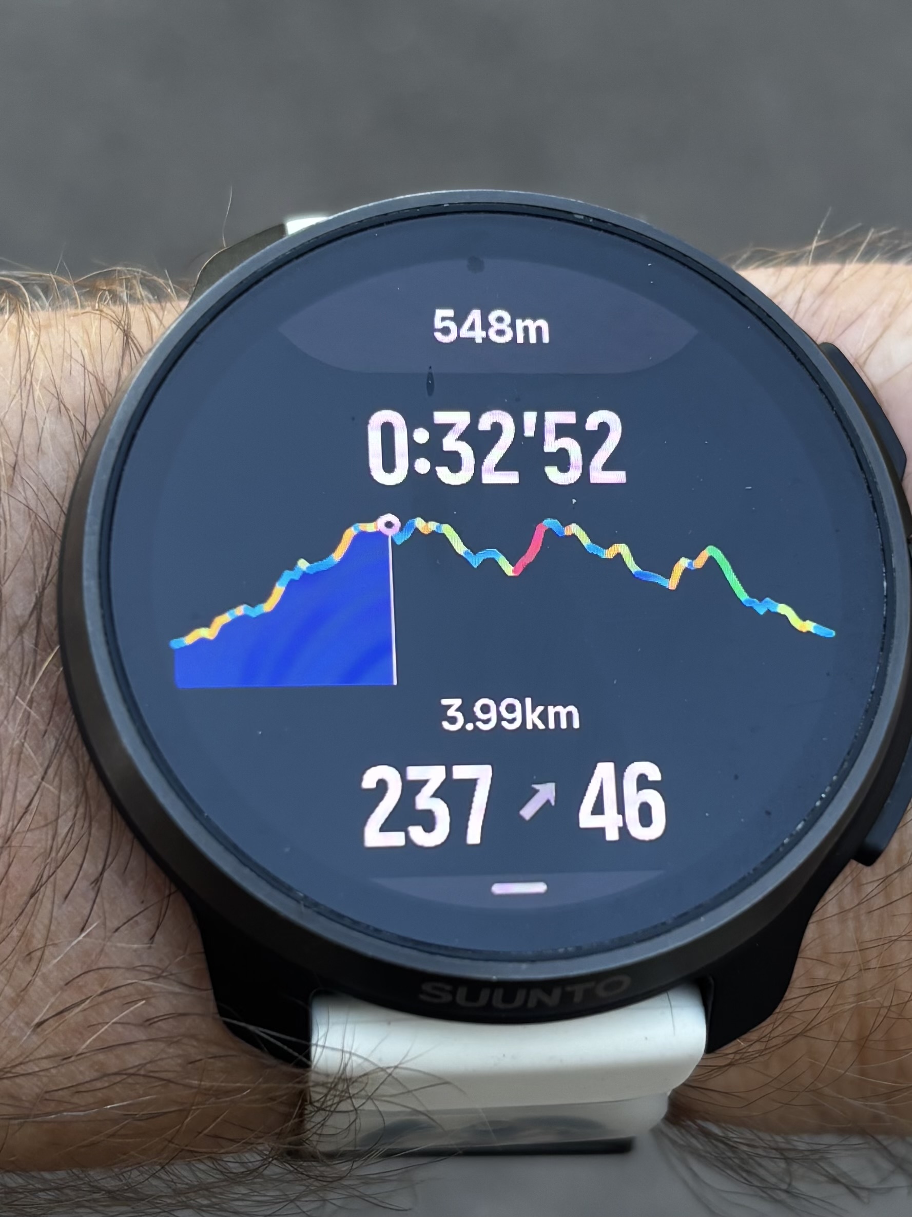
If you turn back, Climb Guidance V1 do not reverse on the main altitude profile, only in the zoomed segment. This results in having a data screen that shows you being eg in a red segment uphill, and then you zoom and find yourself in a green downhill.
Wearing SR with SA on Android 13.
Previously owned/tested: SV, S9, S3. -
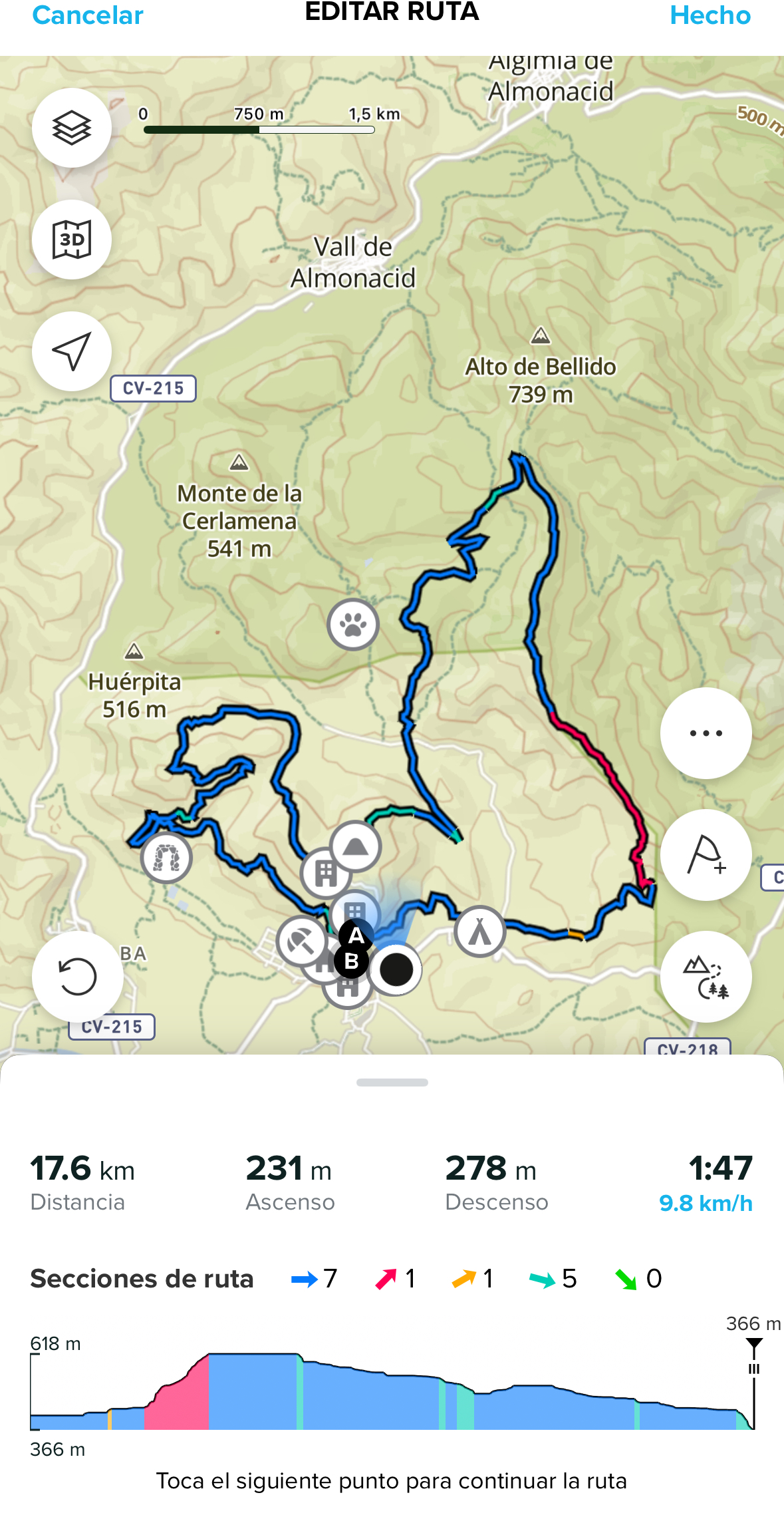
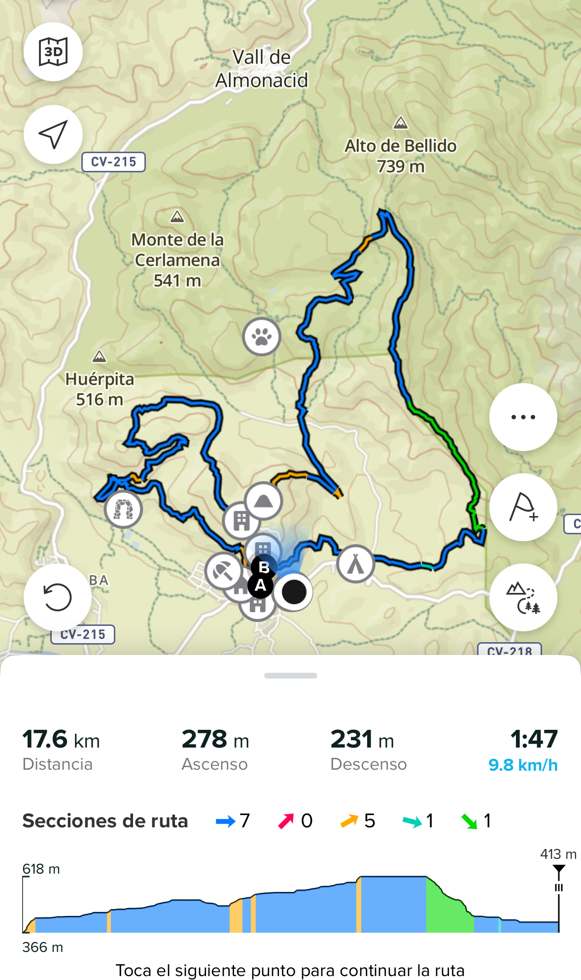
@SergioB Yes, it does, but maybe not exactly as you expect. When you reverse direction, the altitude profile also flips, so the profile shifts to the left, starting again from the beginning (as you can see in the picture).
The colors on the main altitude profile do not change, but you can clearly see if you are going up or down just by looking at the profile itself. At the same time, the sections adapt and show the correct color according to the new direction.
Climb Guidance v2 is different, because the purpose there was to personalize sections based on the direction and user-created waypoints. That’s why in this case the profile only changes direction, not the colors.
For case 1, we are aware of this, and hopefully in the future we can make the main altitude profile colors also change when reversing direction, since that would be more intuitive.
@Suunto Community Manager and Technical
-
@Joaquin please, read @duffman19 's posts.
-
Auto-reverse function was implemented but It is not solved. So work has been done but It is not solved.
-
There are not TBT notifications on imported GPX tracks (this is very important when you import a race track)
-
There are not POIs by default, street names,… I don’t find this very important, but all are missing too.
-
And the alarms thing is still missing. That means that almost everything is like It was before. There’s some work but It is not enough at all (regarding about these things)
About the overall GNSS accuracy It was very good for me but there was a BUT. But as said, please read It further Joaquin. I’m not speaking about an overall GNSS accuracy scenario, but only about a very specific one (that is very important for mountainering)
That BUT was only when the GNSS adquisition was lost many times and during an important time. That’s why I’m saying DesFIt’s video is so important, when he tests the watch in those big buildings. That scenario matches the super bad tracks in open water of some reviewers when you lost the GNSS many many times and during a lot of time (and a time that can be more in one reviewer than other one).
As said, this was also happening for me in deep forest but it’s a while from that. That second part is true. But I’m really surprised to see bad tracks again, because that issue was there before. The thing is that very very few reviewers do those kind of specific tests but I faced that . What I’m explaining and what you see in those tracks I’m talking about is very valuable feedback that your developers and testers should keep in mind. Please talk It internally but have a good look at this thing because in the past there was something there and (looking at those tracks) It seems that It is still something there, for sure.
Speak internally with your developers and testers that, just that. This is feedback for something to look at. You ha e the tracks, they should be looked at.
It is important once we see the bad open water tracks (again as many many times) and that very bad track in those big buildings. This issue has been there in the past. DCR speaks many many times about this in openwater in fact. -
-
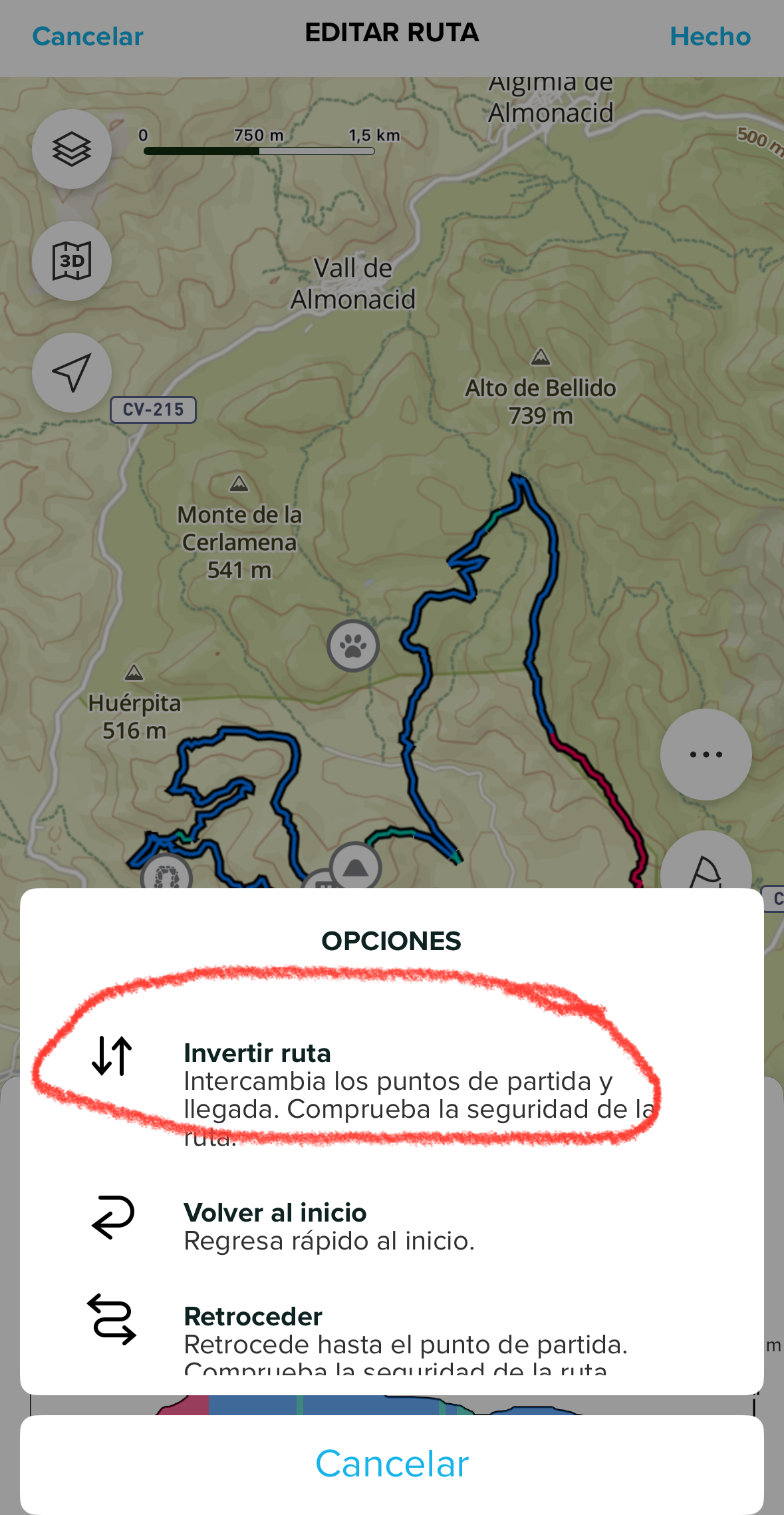
@SergioB other option, if you carry your phone with you, is to simply edit the route in the app and invert its direction. In just a few seconds the route will automatically update on your watch without the need to stop the activity.
-
@dreamer_ My colleague @pavel.samokha can explain about turns in GPX files, he is an expert, but basically if the turns are in GPX they will be in the Suunto app.
We’ve discussed this internally many times. Some brands like Amazfit or Polar create turns based purely on the curve angle, which often results in unnecessary or misleading instructions. Coros doesn’t even display most turns correctly when exporting a GPX, showing the limitations of that approach.
Creating turns only by curve degree can be risky and is not the solution we want. The only brand doing it really well is Garmin, which we understand is using map data rather than curve angles.
-
@Joaquin btw. Thanks a lot for the very nice answers.
One thing only. Amazfit had fixed al the TBTs in the last updates (at least for trail running, I don’t need the faster scenarios but I understand what you are talking about. The thing is they do work, or it seems. I don’t know if their approach is good or bad, speaking technically). They do work even in imported GPX are working by default. I tested this throughly and they were working incredible nice (at least in the last update, I don’t have their devices anymore due to some bugs and missing things I didn’t like). Garmin goes a lot further though. But then, Garmin maps are somehow slow (I read something about the CPU they are using as the cause, but I don’t have the reference)
But the thing is, Suunto has done a fantastic job. But there are some details to have to look at yet
.
-
@dreamer_!
We continue working on it!!
THANKS A LOT FOR YOUR FEEBACK ️
️ -
Thanks @Joaquin , I was aware of the options of reversing the route with the phone. Overall I’m very satisfied with my SR, and the “issue” of reversing the route is not bothering that much (i’m not turning back that often, and when happens I can use the phone “procedure”). So no problem at all for me, I was just trying to underline what could be fixed/improved in the future!
-
@SergioB full agree, we continue improving Climb Guidance
 stay tuned
 -
@duffman19 Suunto has this as well. It’s on navigation
-
@Dimitrios-Kanellopoulos I wasn’t referring to creating your own POIs. I know those exist and use them frequently. We were referring to POIs and landmarks that are native to the on-watch maps. Things like road names, peaks, towns, etc. that are visible without having to create your own POIs in the app. This is one step below routable maps and what other companies have started to add to their mapping experience.
-
@duffman19 this would be awesome feature, because if you have offline map downloaded, and it is just “blind” map without any labels, it is hard to use it for any navigation when you are lost.
-
@Tomas5 is not only about labels.
Actually all brands are putting some POIs by default. I.e: when you are in the maps, you can not only see street names, but water fountains, bus/train stations, pharmacies,…there are some interesting use cases. The most interesting one for me is just the water fountains while trail running. I like a lot to train in the mountains and see there’s a fountain near. The rest is not that important for me but I understand that It could be for hikers and people that does a lot of mountainering.At the end, Suunto has the mountains in the heart, and the Race and Vertical watches cost between 500 and 800 euro…If there are cheaper watches that can fix all the navigation things we were talking about, Suunto should (of course)
And now even more, when Suunto’s watches are better than ever. Perhaps we see a fix soon and the Vertical 2 , has everything in by default. I have a very big interest in that watch
-
Maybe I am not educated enough but please enlighten me how you use these small screens for navigation where labels are useful and important?
I use only the loaded track and follow it. If there is a complicated junction the map helps me to decide which way to go. Zoom level is 25-100m. I use it this way. No more no less. This simple.
Do you check the street or track labels while walking/running/cycling? If I zoom out to get a broader view the labels are disappear on my Garmin. They are not useful any more. I always have a phone on me where I can check the map with every feature’s name. I used twice on device route planning but it was pain in the but. It was a Garmin Edge 830 and a Fenix 7X. Phone is more useful. Usually I plan my tracks at home. If on site route planning is needed I always used my phone to do that not my Garmin.
Now I have Race 2. My only pain is it is not possible to send new track to the watch without internet connection on iOS. I asked support about it. They sent me a long answer. On iOS there is some file handling limitation. Android is ok in this regard. If it will be solved it would become a more outdoor watch.
-
@szleslie this is valid point, i see it only like last case scenario. I can imagine that you are in mountains, not sure how to continue with hike. No internet connection and you have offline maps in watch. So you can look around for some known point, maybe some peak, lake, or something that will help you to get better orientation. And than another scenario, you have created path in phone and on the route there may be some interest point like waterfalls, lakes etc but you didn’t create POIs for each. So it can just help you estimate how far it is to this points. Currently i don’t have watch with offline maps but i can imagine this scenarios to be usefull. Phone is best in backpack, watch is on wrist available all the time to check.
-
@szleslie POIs are not labels, POIs are icons. Then, there are the labels of the streets.
I.e. a water fountains is just a raindrop
-
@Tomas5 You are right. I was thinking where can I use it this way. I came up with same. There are conditions where paper maps and phones are not easily usable if at all. Last chance back up solution can be a watch with full maps with labels and everything and on device routing. It is better than nothing.
-
@dreamer_ I agree. It is useful for some. I think it is not important for me at the moment. Maybe in the future. Who knows. I am a cyclist first than a hiker (more of a short walk than a hike). A simple map is enough for me. Repeat, for me:). I tried local tourist map with colour coded tracks and it was useful on my Garmin. Unfortunately it was painfully slow, the map rendering. Suunto is much better in this regard. Every watch needs some compromises.
If Suunto will add more map features in the future, please make them optional. Switchable labels, POIs etc.
-
@szleslie I agree. My Epix Pro gen2 is not good for hiking because the mapping is incredibly slow.
-
You guys make great points. I don’t think anyone is really using a watch to make high-level navigation decisions (at least I hope not). Suunto’s barebones maps are really great for giving just a bit of context when you are following a pre-planned route.
But having just a few simple POIs baked-in would be really great for the examples you gave above. Things like shelters, water, trailheads, parking lots, cliffs, peaks, and the like (“mountain” focused POIs) would be awesome for quick diversions or emergency situations. And making them an optional layer (good point @szleslie!) would be great so you can still enjoy a simple, uncluttered map experience when you don’t need them.
Having a POI icon layer (no labels, just icons) would be a great way for Suunto to differentiate themselves from the competition while keeping things clean and simple.
Vertical Ti / S9PP Ti / S9P Ti