Suunto app Forum Suunto Community Forum
    • Recent
    • Tags
    • Popular
    • Users
    • Groups
    • Register
    • Login

    Export POIs from Suunto 9

    Scheduled Pinned Locked Moved Suunto 9
    90 Posts 18 Posters 7.6k Views 17 Watching
    Loading More Posts
    • Oldest to Newest
    • Newest to Oldest
    • Most Votes
    Reply
    • Reply as topic
    Log in to reply
    This topic has been deleted. Only users with topic management privileges can see it.
    • D Offline
      djibarian Bronze Member
      last edited by

      Where is it??

      sartoricS 1 Reply Last reply Reply Quote 0
      • sartoricS Offline
        sartoric Moderator @djibarian
        last edited by

        @djibarian
        If you share the route you get the gpx.
        If you’re talking about activities, you should have a “save route” then you can export it

        Not sure about iOS menu

        SVTS - 2.40.38
        SSSWHR BARO Amber - 2.8.32
        Samsung A5 2016 - Android 7.0
        Samsung A33 2022 - Android 14 - One UI 6.1
        Suunto App Android 5.2.5 beta
        Suunto App IOs 2.45.0 (19123) beta on MBP M1

        1 Reply Last reply Reply Quote 0
        • Fenr1rF Offline
          Fenr1r @sartoric
          last edited by

          @sartoric But isn’t that a link, not a file? So you need a data connection to ST servers (wherever) to get that info from your phone (probably in your hand). And, as a route-formatted file, the GPX from ST lacks the timestamps of the track you recorded, right?

          1 Reply Last reply Reply Quote 0
          • D Offline
            djibarian Bronze Member
            last edited by

            @sartoric Really difficult to find and not very user-friendly feature.

            @Fenr1r Right and right, and if you look inside the GPX, coordinates are rounded to 5 decimals and heights to 0 decimals (1 meter).

            The point is, why not add an option to Save as GPX just below the Save as FIT option in the track? And why not add the POIs (waypoints) which have been created in the same time interval as the track? That simple. Instead of that, the app keeps gaining super complex features which I would like to know who is using.

            First things first please. With FIT you have all your heart rate etc; with GPX you have the waypoints. With both, you have all your data to do whatever you want to do with it. There are tons of apps and services to edit and analyze GPX and FIT data, so why not give the user the choice while they (slowly) implement new features?

            I bought a Fenix 6X and have it here in the box. I’m curious to know if Garmin has this same greedy approach with the data.

            And one last thing, is there any plan for a desktop or web app, or even a proper tablet app?

            Dimitrios KanellopoulosD sartoricS 2 Replies Last reply Reply Quote 0
            • Dimitrios KanellopoulosD Offline
              Dimitrios Kanellopoulos Community Manager @djibarian
              last edited by

              @djibarian said in Export POIs from Suunto 9:

              I bought a Fenix 6X and have it here in the box. I’m curious to know if Garmin has this same greedy approach with the data.

              What are you trying to get out of this with all the respect?

              We export to FIT file and GPX for routes. You can convert a FIT file online easily.

              Since the POI feature is just going live, we can collect feedback for the specific needs of sharing etc.

              That simple. Instead of that, the app keeps gaining super complex features which I would like to know who is using.

              What are those complicated features that noone is using?

              Community Manager / Admin @Suunto
              Creator of Quantified-Self.io
              youtube.com/c/dimitrioskanellopoulos
              https://instagram.com/dimitrioskanellopoulos
              https://www.strava.com/athletes/7586105

              1 Reply Last reply Reply Quote 1
              • sartoricS Offline
                sartoric Moderator @djibarian
                last edited by

                @djibarian said in Export POIs from Suunto 9:

                And one last thing, is there any plan for a desktop or web app, or even a proper tablet app?

                You really should try the search function of this forum 😁

                SVTS - 2.40.38
                SSSWHR BARO Amber - 2.8.32
                Samsung A5 2016 - Android 7.0
                Samsung A33 2022 - Android 14 - One UI 6.1
                Suunto App Android 5.2.5 beta
                Suunto App IOs 2.45.0 (19123) beta on MBP M1

                1 Reply Last reply Reply Quote 0
                • D Offline
                  djibarian Bronze Member
                  last edited by

                  @Dimitrios-Kanellopoulos Don’t get me wrong. If I’m spending time writing here is because I made a choice and chose Suunto. And I like the watch and the ecosystem in general. But also I see very big flaws that I wanted to share and get fixed if possible.

                  FIT doesn’t include waypoints, and converting to route and sharing creates an unusable GPX which lacks time and have the values clamped. I see recording tracks and waypoints and being able to access them as a really basic functionality of a GPS watch, and also I think that my data is mine and I should be able to access it.

                  If Suunto doesn’t understand that, I’m sorry but I will find another company that fits my basic needs. I remember the time when I had an old gpsmap62 brick and the only thing I had to do was to connect it to the computer and instantly see the tracks and the waypoints I recorded.

                  Now is a complete frustration to go out and try to do the same. It’s not only that it’s difficult, it’s impossible.

                  Dimitrios KanellopoulosD 1 Reply Last reply Reply Quote 0
                  • Dimitrios KanellopoulosD Offline
                    Dimitrios Kanellopoulos Community Manager @djibarian
                    last edited by

                    @djibarian I can for sure make suunto understand but first of all let us two understand.

                    FIT doesn’t include waypoints, and converting to route and sharing creates an unusable GPX which lacks time and have the values clamped. I see recording tracks and waypoints and being able to access them as a really basic functionality of a GPS watch, and also I think that my data is mine and I should be able to access it.

                    Kind correct the above.

                    However, when we export the activity as a route / or a route we do include waypoints in a GPX file. What are you missing from what? I dont get it.

                    Help me to help you.

                    Community Manager / Admin @Suunto
                    Creator of Quantified-Self.io
                    youtube.com/c/dimitrioskanellopoulos
                    https://instagram.com/dimitrioskanellopoulos
                    https://www.strava.com/athletes/7586105

                    isaziI 1 Reply Last reply Reply Quote 0
                    • isaziI Offline
                      isazi Moderator @Dimitrios Kanellopoulos
                      last edited by

                      @Dimitrios-Kanellopoulos I have the feeling @djibarian means POIs recorded with the watch, and not route waypoints.

                      Watch: Suunto Vertical Ti

                      Blog: isazi's home

                      Dimitrios KanellopoulosD 1 Reply Last reply Reply Quote 1
                      • Dimitrios KanellopoulosD Offline
                        Dimitrios Kanellopoulos Community Manager @isazi
                        last edited by Dimitrios Kanellopoulos

                        @isazi then POIS are inside the app.

                        Since the watch doens’t relate recorded POIS during or out of excersise as they are decoupled.

                        Those pois do sync but then you need to create a route with those pois as waypoints.

                        So here is the difference or the confusion.

                        POI is not waypoint. It can be recorded outside an activity.
                        Waypoints are waypoints on a route.

                        When creating a route you can add waypoints. Those are exported in a GPX
                        When you are doing an activity you can create pois. When also outside of the activity you can also create pois for example a nice spot while walking in the town. Those will sync with the app and be shown in the map.

                        You can later on after your run/hike sync. That will get the pois and the route you did.
                        You convert that workout to a route and then you create the waypoints of that route from the pois that are overlayed on the map. You export that route to GPX and apparently you have what you need.

                        Community Manager / Admin @Suunto
                        Creator of Quantified-Self.io
                        youtube.com/c/dimitrioskanellopoulos
                        https://instagram.com/dimitrioskanellopoulos
                        https://www.strava.com/athletes/7586105

                        1 Reply Last reply Reply Quote 0
                        • D Offline
                          djibarian Bronze Member
                          last edited by

                          @isazi Exactly, I mean POIs recorded with the watch, not as part of the route.

                          Dimitrios, you say "You can later on after your run/hike sync. That will get the pois and the route you did. You convert that workout to a route and then you create the waypoints of that route from the pois that are overlayed on the map. You export that route to GPX and apparently you have what you need.”

                          …You can later on after your run/hike sync. That will get the pois and the route you did.

                          OK

                          …You convert that workout to a route and then you create the waypoints of that route from the pois that are overlayed on the map.

                          How to create the waypoints from the POIs, manually? 1) converting track to route throws away time info. 2) waypoints also have the time which were recorded, which is also lost.

                          …You export that route to GPX and apparently you have what you need.

                          That GPX doesn’t have time info and the coordinates and elevation are clamped.

                          EASY SOLUTION:

                          In the POIs tab, add an option to export all of them as GPX (or ideally, the selected ones). That would allow you to export the track as FIT (and then convert it to GPX without losing any data) and add to that GPX the POIs exported as GPX too, using a text editor and copy/pasting inside the XML. Not ideal, but at least you could extract ALL your data.

                          Dimitrios KanellopoulosD sartoricS 2 Replies Last reply Reply Quote 0
                          • Dimitrios KanellopoulosD Offline
                            Dimitrios Kanellopoulos Community Manager @djibarian
                            last edited by

                            @djibarian well the information on the poi does contain the time created afaik.

                            So this gets more complicated. You want:

                            Activity export as GPX with the POIS that have a timestamp that belongs inside the activity timeframe.

                            Unfortunately and coming back to some previous comment afaik this was never possible with movescount etc.

                            Not very sure why this is a problem , in the perspective of something that was not there before. Sure if can be a feature request but we cannot say it’s just export pois.

                            I suppose you want a GPX file with POIS that you load to another service right?

                            Community Manager / Admin @Suunto
                            Creator of Quantified-Self.io
                            youtube.com/c/dimitrioskanellopoulos
                            https://instagram.com/dimitrioskanellopoulos
                            https://www.strava.com/athletes/7586105

                            M 1 Reply Last reply Reply Quote 0
                            • D Offline
                              djibarian Bronze Member
                              last edited by

                              Saving a route as GPX including the waypoints created to that route is OK, as the lack of precision is not a problem because you usually use that route to follow the path.

                              But by the way, one problem with those waypoints is that the Suunto app doesn’t let you create a waypoint at any place, it has to be INSIDE the path. That’s a problem if you want to mark a summit but there is no path to reach it, and you now you can reach it across the field from the path, but need the waypoint to locate the summit.

                              Dimitrios KanellopoulosD 1 Reply Last reply Reply Quote 0
                              • sartoricS Offline
                                sartoric Moderator @djibarian
                                last edited by sartoric

                                @djibarian
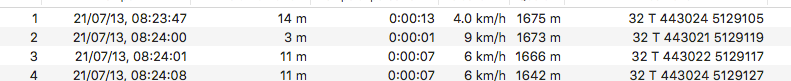
                                I guess you’re not talking about POI nor WP

                                you are talking about Track Points.
                                Points added while recording the track (based on gpsmap 62 mentioned before).

                                Like these , isn’t it ?
                                track points.png

                                SVTS - 2.40.38
                                SSSWHR BARO Amber - 2.8.32
                                Samsung A5 2016 - Android 7.0
                                Samsung A33 2022 - Android 14 - One UI 6.1
                                Suunto App Android 5.2.5 beta
                                Suunto App IOs 2.45.0 (19123) beta on MBP M1

                                1 Reply Last reply Reply Quote 0
                                • Dimitrios KanellopoulosD Offline
                                  Dimitrios Kanellopoulos Community Manager @djibarian
                                  last edited by

                                  @djibarian you can do a free drawing in the route planner for that specific case

                                  Community Manager / Admin @Suunto
                                  Creator of Quantified-Self.io
                                  youtube.com/c/dimitrioskanellopoulos
                                  https://instagram.com/dimitrioskanellopoulos
                                  https://www.strava.com/athletes/7586105

                                  1 Reply Last reply Reply Quote 0
                                  • D Offline
                                    djibarian Bronze Member
                                    last edited by

                                    Nope, you cannot create a POI outside the route. Try it.

                                    Dimitrios KanellopoulosD 1 Reply Last reply Reply Quote 0
                                    • Dimitrios KanellopoulosD Offline
                                      Dimitrios Kanellopoulos Community Manager @djibarian
                                      last edited by

                                      @djibarian waypoint you mean? I just told you how. Do a free drawing to that peak and then long hold to add a waypoint.

                                      If you don’t want to pass from the peak as of routing then no need todo it at the route planner. Add a poi at that peak. When in the activity, you can navigate to that poi via the navigation menu

                                      Community Manager / Admin @Suunto
                                      Creator of Quantified-Self.io
                                      youtube.com/c/dimitrioskanellopoulos
                                      https://instagram.com/dimitrioskanellopoulos
                                      https://www.strava.com/athletes/7586105

                                      1 Reply Last reply Reply Quote 0
                                      • D Offline
                                        djibarian Bronze Member
                                        last edited by

                                        oh, free drawing, I got it. Thanks!

                                        1 Reply Last reply Reply Quote 0
                                        • D Offline
                                          djibarian Bronze Member
                                          last edited by

                                          and how do you add a poi to the peak outside the route planner?

                                          Dimitrios KanellopoulosD 1 Reply Last reply Reply Quote 0
                                          • Dimitrios KanellopoulosD Offline
                                            Dimitrios Kanellopoulos Community Manager @djibarian
                                            last edited by Dimitrios Kanellopoulos

                                            @djibarian go to the map. Tap on the peak -> create POI -> name etc -> press add to watch.

                                            Make sure you are on version 4.33.x (x is any number)

                                            (do the above outside the route creation)

                                            Community Manager / Admin @Suunto
                                            Creator of Quantified-Self.io
                                            youtube.com/c/dimitrioskanellopoulos
                                            https://instagram.com/dimitrioskanellopoulos
                                            https://www.strava.com/athletes/7586105

                                            D 1 Reply Last reply Reply Quote 0
                                            • First post
                                              Last post

                                            Suunto Terms | Privacy Policy