Software update 2.12.30 Staged Release for S3/S5/S9
-
@MiniForklift said in Software update 2.12.30 Staged Release for S3/S5/S9:
Yeah I have tried changing it to a Monday which works… until I upload my next workout and have to sync my phone/watch
Yep, at the moment the Suunto App uses your locale settings, and pushes that to your watch, overriding everything you manually set. It is useful, except for the lack of deciding which is the first day of the week

Hey potentially dumb question, is there something in settings that allows you to turn the backlight on during training by shaking the wrist? Just got my running partner to switch from Garmin to a S9B and he says he can’t see a way to do this; he does most of his training before sunrise and as a result is having to run with the backlight permanently on
Don’t know of a way to do that on the S9.
-
@MiniForklift only via options -> Backlight -> on. Either during or before. Its remembered though.
-
I am very happy with the update. I would like to share a couple of thoughts, maybe @Dimitrios-Kanellopoulos have information on them
-Has POIs (not WP) management been abandoned? Although in the watch it would be great, I mean whether in watch or through the App.
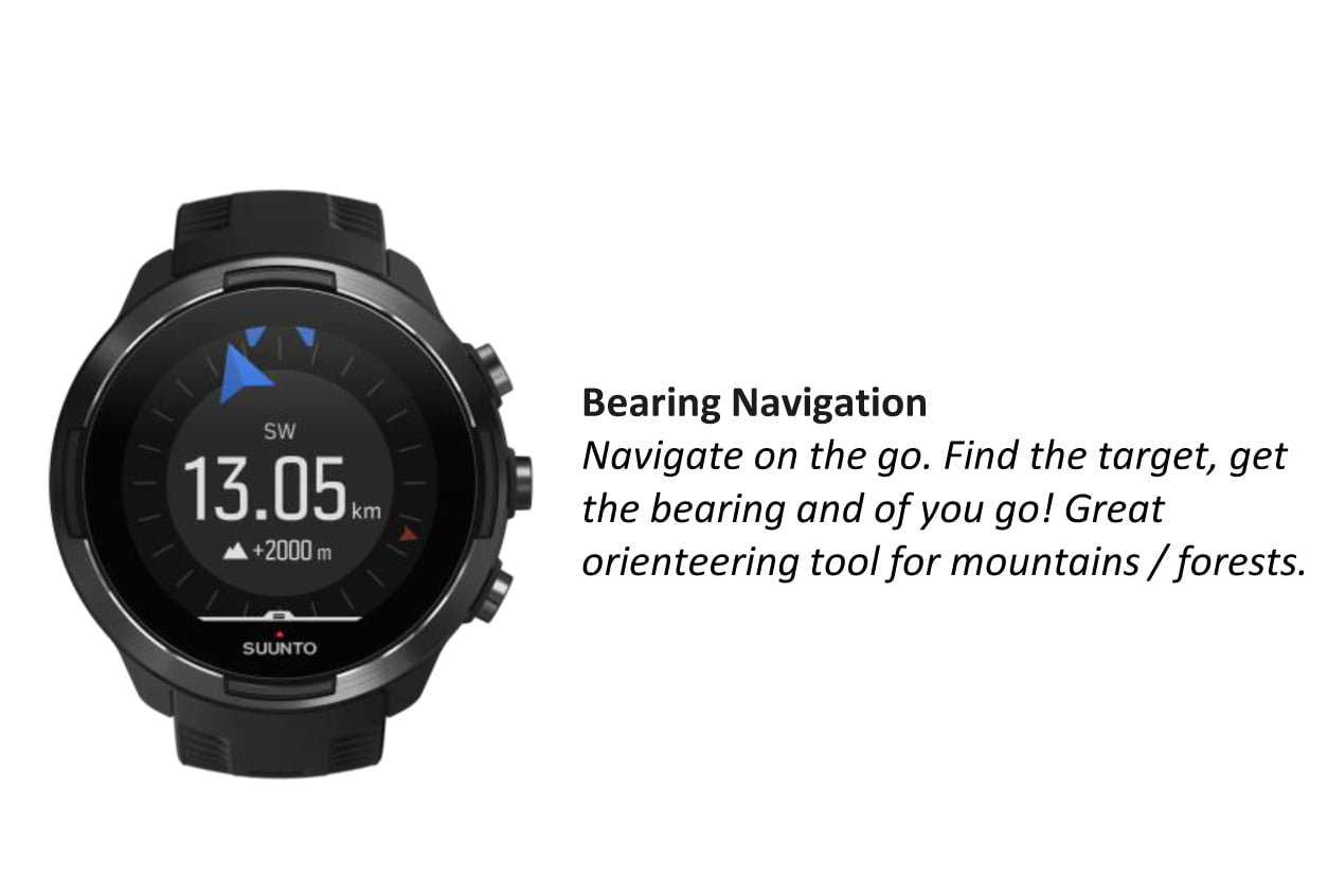
-New bearing lock with distance and altitude is a great addition, but… Is the impossibility to access during an exercise something to be solved later or was simply never understood to work that way. Additionally, I tried it today and discovered that I had to point the direction. It makes it useless unless you have a direct sight of the point. It could be a good alternative for POIs if we could see the bearing in degrees. Then we could fix the point in a map (paper or phone), find the bearing and distance, and put it into the watch.
-Locking button (I know, you are insisting on it, it would be great to have it). Do you think it possible in the future? -
@Efejota said in Software update 2.12.30 Staged Release for S3/S5/S9:
-Has POIs (not WP) management been abandoned? Although in the watch it would be great, I mean whether in watch or through the App.
It will come, hopefully this year
-
@Efejota said in Software update 2.12.30 Staged Release for S3/S5/S9:
Is the impossibility to access during an exercise something to be solved later or was simply never understood to work that way.
It has been asked but I am not sure
-
@Efejota I suppose (and this is such a kludge) …
You could work out your desired destination’s bearing from the map, somewhere with an outdoor view. Sight and note the most distant identifiable point on the bearing and duplicate the process with the watch, locking in the arrow (& adding distance/elevation to taste). The reverse of actual compass navigation.
Or (even worse but possible in-tent) move the watch to line up its 12-6 axis with the compass plate/sight axis while the latter sits in the appropriate position on the map (as you would use it to find the bearing and maybe measure distance).
Make your angular error margins big, make 'em early.
-
@Dimitrios-Kanellopoulos, @Fenr1r will like this information
-
@Fenr1r you are right. But the possibility to see bearing in degrees rather than just pointing to a direction will lessen the possibility of angular error. Maybe I am mistaken, but I did not see that possibility in my first test with the feature.
-
@Efejota Exactly. Sorry: that last line was meant to be an ironic coda to the “kludge” stuff. I am not genuinely keen on angular errors, big or small.
Viva Integers!
-
@Fenr1r how about errors that need user input all the time. I think that costs more.
See
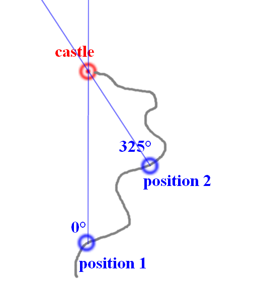
Its very easy to make a user input error for Angle Imo but I might be wrong.
You could change the bearing to the Castle 2 times quite easy though. Right ?
I like this discussion

-
@Dimitrios-Kanellopoulos Depends on the purpose of your bearings. In your (excellently impromptu) pic, am I heading for that castle or just using it as a reference point to locate myself on its road? And what is the currency of this “cost”? Stopped time? Effort? Irritation?
I use bearings where there aren’t usable paths going where I want to go in the way I want to go. If I’m walking to that castle, there would be no 325d bearing for me because I’d either be walking North from pos1 or along that road. And probably not either, as castles are the known haunts of depraved aristocrats, many of whom are vampires.
Elsewhere, course correction can be constant. It’s why you check the terrain folds for their potential to obstruct real world features on your bearing. Assuming you can see anything. Fog, forests and night are not helpful in this regard.
(You know how you avoid those angular/sighting errors requiring repeated user input to reach a mapped feature? Coordinate entry. But who would put such a thing on a watch?)
That was long. I like this discussion too.
-
@Fenr1r That is right.
How do I see the POIs use for navigation and how the absence of coordinates entry into the watch might be overcome?
My intended use (thankfully, I NEEDED it just a few times) is to be sure to find a certain point when I cannot navigate just with ground references (fog, forest, whatever). Also, in my A3P times, to have a clue on how far I where (I know, very basic, nothing compared to route ETE in S9B).
Let’s use the castle. I have it as a POI, then I can “reach” it if I can navigate to that point if I lost the road or if there is no road at all. Fog, night and wolfs are added components. Vampires come next. Coordinates is the best method.
If I cannot enter the castle coordinates, my only possible way is (if I know where I am in the map, of course), to get the bearing in degrees and an (approximate) distance and enter it using the new feature in navigation. A worse alternative, of course, but at least a possibility, similar to traditional compass navigation. I will need to check from time to time and it is very prone to error, but it is the best I can imagine if I cannot enter coordinates.
Here comes the conclusion. As most of the times I think of this feature for cases where my visibility of the destination is null (why should I need navigation if I have direct eye contact with my intended point), not knowing the bearing in degrees when locking the compass makes the alternative almost useless.
To be honest, what could the current implementation be useful for? I guess that there may be scenarios, but probably in sports that I do not practice.
I like the direction of Suunto with the firmware, but I still see that it has lost lot of its traditional ties with navigation.
And I like the discussion too
-
@Fenr1r @Dimitrios-Kanellopoulos @Efejota
I would like to clarify the original idea behind the picture (it’s mine in fact
 )
)  This is the situation where the current bearing functionality will not help much unless you know the distance to the castle… But, via @Dimitrios-Kanellopoulos I yesterday suggested to Suunto guys adding a “triangulation” feature: you measure bearing to the castle from position 1, then you measure bearing from position 2 and the watch calculates the coordinates of the castle based on the intersection of 2 bearings
-
@inkognito Very smart! In my opinion (I know nothing of programming, I must confess), easier to get coordinates and enter them directly. But, of course, it is very helpful if you do not know coordinates (like having a plain paper map)
-
@Efejota said in Software update 2.12.30 Staged Release for S3/S5/S9:
I am very happy with the update. I would like to share a couple of thoughts, maybe @Dimitrios-Kanellopoulos have information on them
Additionally, I tried it today and discovered that I had to point the direction. It makes it useless unless you have a direct sight of the point. It could be a good alternative for POIs if we could see the bearing in degrees. Then we could fix the point in a map (paper or phone), find the bearing and distance, and put it into the watch.
Sorry, i don’t get this point. Yes, you need to point, but at the same time you get the bearing displayed in degrees. So you can do the pointing in the fog or in the tent - as long as you know your desired bearing, just point the watch until the number is what you want.
![IMG_1223-scaled[1].jpg](/assets/uploads/files/1599653940837-img_1223-scaled-1.jpg)
-
@Efejota said in Software update 2.12.30 Staged Release for S3/S5/S9:
Fog, night and wolfs
Where wolfs?
-
@Fenr1r near the castle 51° SE (reverse bearing of the tent from the castle = SE 51°) . Please follow with attention

-
@inkognito (& @Efejota) Interesting. And fine (uncredited-as-initially-displayed-the-shame) map. How would you then use those one-time generated coordinates? Would you be doing this with sequential major features along your route JIC the road became impassable?
If the watch can hold onto a first bearing, without needing to overwrite it with the second, I’d quite like it to be able to save that first bearing … and entered distance … and maybe elevation … maybe with an icon … and a name …
-
@chrisc92 said in Software update 2.12.30 Staged Release for S3/S5/S9:
@Fenr1r near the castle 51° SE (reverse bearing of the tent from the castle = SE 51°) . Please follow with attention

could you share coordinates to avoid visit this area
 ?
? -
@Mff73 Not on any map, apparently - so no coordinates. And the satellite image resolution of the region seems to be measurable in kilometres. I asked a Cure fan of my acquaintance and she told me it’s in the wooded hills above the small village of Dontgonearthe.
