Suunto app Forum Suunto Community Forum
    • Recent
    • Tags
    • Popular
    • Users
    • Groups
    • Register
    • Login

    Issues altitude diagram

    Scheduled Pinned Locked Moved Spartan
    54 Posts 10 Posters 3.6k Views 10 Watching
    Loading More Posts
    • Oldest to Newest
    • Newest to Oldest
    • Most Votes
    Reply
    • Reply as topic
    Log in to reply
    This topic has been deleted. Only users with topic management privileges can see it.
    • Stefan KerstingS Offline
      Stefan Kersting @Brad_Olwin
      last edited by

      @Brad_Olwin without calibration it looks like this. The altitude displayed on the watch before I started it was -19 meters

      AD8D8F17-8001-4080-AF71-1AE716EEBCBF.jpeg

      Instagram: https://www.instagram.com/helgelandsbukken/
      https://www.instagram.com/suunto_adventures/
      IG: Helgelandsbukken, suunto_adventures
      Vimeo: vimeo.com/helgelandsbukken
      Blogg: https://turblogg.midnattsola.com

      isaziI Dimitrios KanellopoulosD 2 Replies Last reply Reply Quote 0
      • isaziI Offline
        isazi Moderator @Stefan Kersting
        last edited by

        @Stefan-Kersting did you already try to clean the baro sensor?

        Watch: Suunto Vertical Ti

        Blog: isazi's home

        1 Reply Last reply Reply Quote 0
        • Dimitrios KanellopoulosD Offline
          Dimitrios Kanellopoulos Community Manager @Stefan Kersting
          last edited by

          @Stefan-Kersting what is the altitude you would expect ?

          0 ?

          Community Manager / Admin @Suunto
          Creator of Quantified-Self.io
          youtube.com/c/dimitrioskanellopoulos
          https://instagram.com/dimitrioskanellopoulos
          https://www.strava.com/athletes/7586105

          Stefan KerstingS 1 Reply Last reply Reply Quote 0
          • Stefan KerstingS Offline
            Stefan Kersting @Dimitrios Kanellopoulos
            last edited by

            @Dimitrios-Kanellopoulos starting at 5 masl. That is 100 percent sure altitude at home

            Instagram: https://www.instagram.com/helgelandsbukken/
            https://www.instagram.com/suunto_adventures/
            IG: Helgelandsbukken, suunto_adventures
            Vimeo: vimeo.com/helgelandsbukken
            Blogg: https://turblogg.midnattsola.com

            Mff73M 1 Reply Last reply Reply Quote 0
            • Mff73M Offline
              Mff73 @Stefan Kersting
              last edited by Mff73

              @Stefan-Kersting
              Android app or iOS?
              With Android, there are raw data files in phone that can be imported in QS : you could see GPS altitude, and some other data that may help understand if fusedalti worked properly or not, of if GPS signal was good enough.
              https://forum.suunto.com/post/33052

              Suunto Spartan Ultra (since 2016) FW: 2.8.24 (retired)
              Suunto Vertical all black
              Wife : S9PP
              SA: Always the latest beta :)
              Android 13, Galaxy S205G

              Stefan KerstingS 1 Reply Last reply Reply Quote 1
              • Stefan KerstingS Offline
                Stefan Kersting @Mff73
                last edited by

                @Mff73 no have iOS. But it could be nice to have information about the signal quality. Maybe a azimuth Display or something like that. But I don’t know if the problem lies there

                Instagram: https://www.instagram.com/helgelandsbukken/
                https://www.instagram.com/suunto_adventures/
                IG: Helgelandsbukken, suunto_adventures
                Vimeo: vimeo.com/helgelandsbukken
                Blogg: https://turblogg.midnattsola.com

                1 Reply Last reply Reply Quote 0
                • Stefan KerstingS Offline
                  Stefan Kersting
                  last edited by Stefan Kersting

                  Did everything you guys recommend. Used Auto calibrate, manual calibrating, had the watch for half an hour in warm water. But when your supposed to start at 4 masl and finish at masl this result is absolutely unacceptable 👿

                  Instagram: https://www.instagram.com/helgelandsbukken/
                  https://www.instagram.com/suunto_adventures/
                  IG: Helgelandsbukken, suunto_adventures
                  Vimeo: vimeo.com/helgelandsbukken
                  Blogg: https://turblogg.midnattsola.com

                  Brad_OlwinB 1 Reply Last reply Reply Quote 0
                  • Stefan KerstingS Offline
                    Stefan Kersting
                    last edited by

                    B1ECFC49-3CCF-4C58-9BDA-5DE49138E92F.png

                    Instagram: https://www.instagram.com/helgelandsbukken/
                    https://www.instagram.com/suunto_adventures/
                    IG: Helgelandsbukken, suunto_adventures
                    Vimeo: vimeo.com/helgelandsbukken
                    Blogg: https://turblogg.midnattsola.com

                    1 Reply Last reply Reply Quote 0
                    • Brad_OlwinB Offline
                      Brad_Olwin Moderator @Stefan Kersting
                      last edited by

                      @Stefan-Kersting It could be the sensor is faulty too, hard to say.

                      Vector/T6c/Ambit 3 Peak/S5 Copper/S3/S7 Ti/S9 baro Ti/S9P Ti/S9PP Ti/Vertical Ti/Race Ti/RaceS/Ocean/Wing

                      Stefan KerstingS 2 Replies Last reply Reply Quote 0
                      • Stefan KerstingS Offline
                        Stefan Kersting @Brad_Olwin
                        last edited by

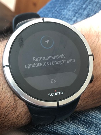
                        @Brad_Olwin when Auto calibrating, do you get a confirmation? I just have this screen even when outside and trying to auto calibrate

                        image.jpg

                        Instagram: https://www.instagram.com/helgelandsbukken/
                        https://www.instagram.com/suunto_adventures/
                        IG: Helgelandsbukken, suunto_adventures
                        Vimeo: vimeo.com/helgelandsbukken
                        Blogg: https://turblogg.midnattsola.com

                        Dimitrios KanellopoulosD sartoricS 2 Replies Last reply Reply Quote 0
                        • Dimitrios KanellopoulosD Offline
                          Dimitrios Kanellopoulos Community Manager @Stefan Kersting
                          last edited by

                          @Stefan-Kersting I think no on Spartans. However you can set the altitude to 1000m and check if its changed

                          Community Manager / Admin @Suunto
                          Creator of Quantified-Self.io
                          youtube.com/c/dimitrioskanellopoulos
                          https://instagram.com/dimitrioskanellopoulos
                          https://www.strava.com/athletes/7586105

                          Stefan KerstingS 1 Reply Last reply Reply Quote 0
                          • sartoricS Offline
                            sartoric Moderator @Stefan Kersting
                            last edited by sartoric

                            @Stefan-Kersting
                            Never, but it say “in background” so … I never expected it 😁 but I noticed a blink in the watch face

                            SVTS - 2.40.38
                            SSSWHR BARO Amber - 2.8.32
                            Samsung A5 2016 - Android 7.0
                            Samsung A33 2022 - Android 14 - One UI 6.1
                            Suunto App Android 5.2.5 beta
                            Suunto App IOs 2.45.0 (19123) beta on MBP M1

                            1 Reply Last reply Reply Quote 0
                            • Stefan KerstingS Offline
                              Stefan Kersting @Dimitrios Kanellopoulos
                              last edited by

                              @Dimitrios-Kanellopoulos I get a gps position but after a manual calibration on 500 masl tja altitude isn’t adjusted when using auto calibration. Have to do it manually

                              Instagram: https://www.instagram.com/helgelandsbukken/
                              https://www.instagram.com/suunto_adventures/
                              IG: Helgelandsbukken, suunto_adventures
                              Vimeo: vimeo.com/helgelandsbukken
                              Blogg: https://turblogg.midnattsola.com

                              Dimitrios KanellopoulosD 1 Reply Last reply Reply Quote 0
                              • Dimitrios KanellopoulosD Offline
                                Dimitrios Kanellopoulos Community Manager @Stefan Kersting
                                last edited by

                                @Stefan-Kersting it needs up to 15 mins

                                Community Manager / Admin @Suunto
                                Creator of Quantified-Self.io
                                youtube.com/c/dimitrioskanellopoulos
                                https://instagram.com/dimitrioskanellopoulos
                                https://www.strava.com/athletes/7586105

                                Stefan KerstingS 1 Reply Last reply Reply Quote 0
                                • Stefan KerstingS Offline
                                  Stefan Kersting @Dimitrios Kanellopoulos
                                  last edited by

                                  @Dimitrios-Kanellopoulos ok then I have to wait more than 2-3 minutes…

                                  Instagram: https://www.instagram.com/helgelandsbukken/
                                  https://www.instagram.com/suunto_adventures/
                                  IG: Helgelandsbukken, suunto_adventures
                                  Vimeo: vimeo.com/helgelandsbukken
                                  Blogg: https://turblogg.midnattsola.com

                                  1 Reply Last reply Reply Quote 0
                                  • Stefan KerstingS Offline
                                    Stefan Kersting @Brad_Olwin
                                    last edited by

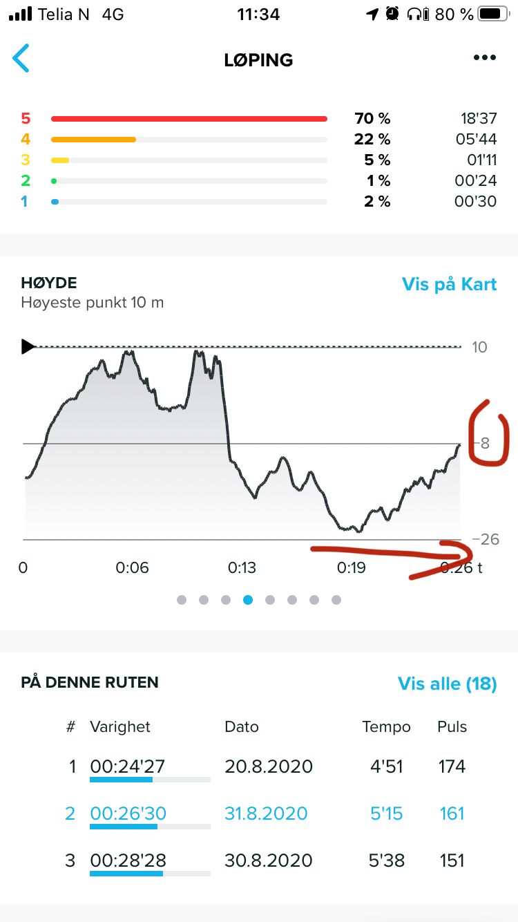
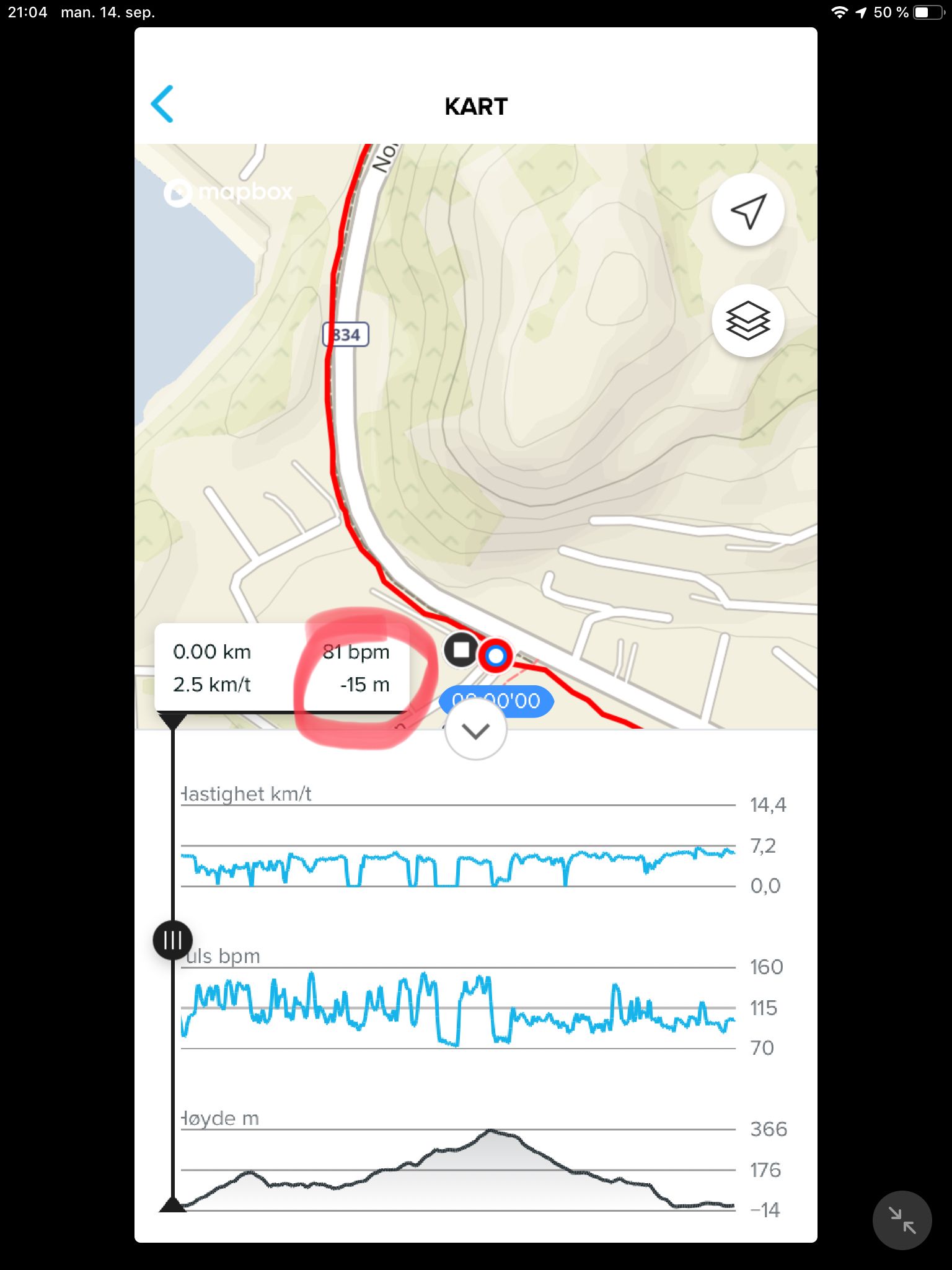
                                    @Brad_Olwin now I did a hike and not a run in order to have enough time to follow the altitude on the watch. The interesting thing was that I started at an altitude of 5 masl and with a fast ascent to 30 masl and after a short time the altitude was at 13masl which was realistic. So that must be an issue with the satellite fix at the start. BUT I have never seen a negative altitude on the watch and when downloaded I see that the lowest point was registered with -15 below sea level. So now I don’t understand anything. The watch displays another altitude than SA…
                                    E22434CC-2900-4F9D-B311-F9E538EC4368.jpeg

                                    Instagram: https://www.instagram.com/helgelandsbukken/
                                    https://www.instagram.com/suunto_adventures/
                                    IG: Helgelandsbukken, suunto_adventures
                                    Vimeo: vimeo.com/helgelandsbukken
                                    Blogg: https://turblogg.midnattsola.com

                                    1 Reply Last reply Reply Quote 0
                                    • J Offline
                                      johann.fuehrer Bronze Member
                                      last edited by johann.fuehrer

                                      Hello, I’m surprised that this “my altitude does not match with my map reading” topic is coming up ever and ever again. I have written about this somewhere in the past, so here some information from guys who know what it is about: https://www.usgs.gov/faqs/why-dont-elevations-your-maps-agree-those-provided-my-gps-system-which-ones-are-correct?qt-news_science_products=0#qt-news_science_products

                                      This is one of the reasons, Garmin brought in DEM data to Fenix models (I think mesh points in 30m grid)…

                                      That is why I suggested a local offset which CAN be set manually and would shift the GPS altitude calculated by this offset for EVREY altitude value - right ones and wrong ones (bad GPS, abro i.e.). So also fused alti would work. It would not touch the GPS altitude reading and calculation directly, but after getting GPS altitude + fused alti calculations, it would add/sub the local offset of the GPS_geoid_to_real_map_alti difference which has been set manually. my5c

                                      (which would mean: exact the same altitude profile but shiftet to real altitude due to offset…)

                                      Fenr1rF Dimitrios KanellopoulosD 2 Replies Last reply Reply Quote 0
                                      • Fenr1rF Offline
                                        Fenr1r @johann.fuehrer
                                        last edited by Fenr1r

                                        @johann-fuehrer said in Issues altitude diagram:

                                        TruFusedAlti. Do we know if Suunto uses the datum elevation or that from satellite triangulation? Or one and then the other?

                                        my5c

                                        Inflation?

                                        J 1 Reply Last reply Reply Quote 0
                                        • Dimitrios KanellopoulosD Offline
                                          Dimitrios Kanellopoulos Community Manager @johann.fuehrer
                                          last edited by

                                          @johann-fuehrer afaik Suunto uses mean sea level. What am I missing ?

                                          Community Manager / Admin @Suunto
                                          Creator of Quantified-Self.io
                                          youtube.com/c/dimitrioskanellopoulos
                                          https://instagram.com/dimitrioskanellopoulos
                                          https://www.strava.com/athletes/7586105

                                          J 1 Reply Last reply Reply Quote 0
                                          • J Offline
                                            johann.fuehrer Bronze Member @Fenr1r
                                            last edited by

                                            @Fenr1r said in Issues altitude diagram:

                                            @johann-fuehrer said in Issues altitude diagram:

                                            TruFusedAlti. Do we know if Suunto uses the datum elevation or that from satellite triangulation? Or one and then the other?

                                            Dont know. BTW: This was the thread & post I referred to, needed some time to find it again 😉 … https://forum.suunto.com/post/36919

                                            Fenr1rF 1 Reply Last reply Reply Quote 0
                                            • First post
                                              Last post

                                            Suunto Terms | Privacy Policy