Map Rendering and Trail Visibility after Software Update 2.43.8/.12
-
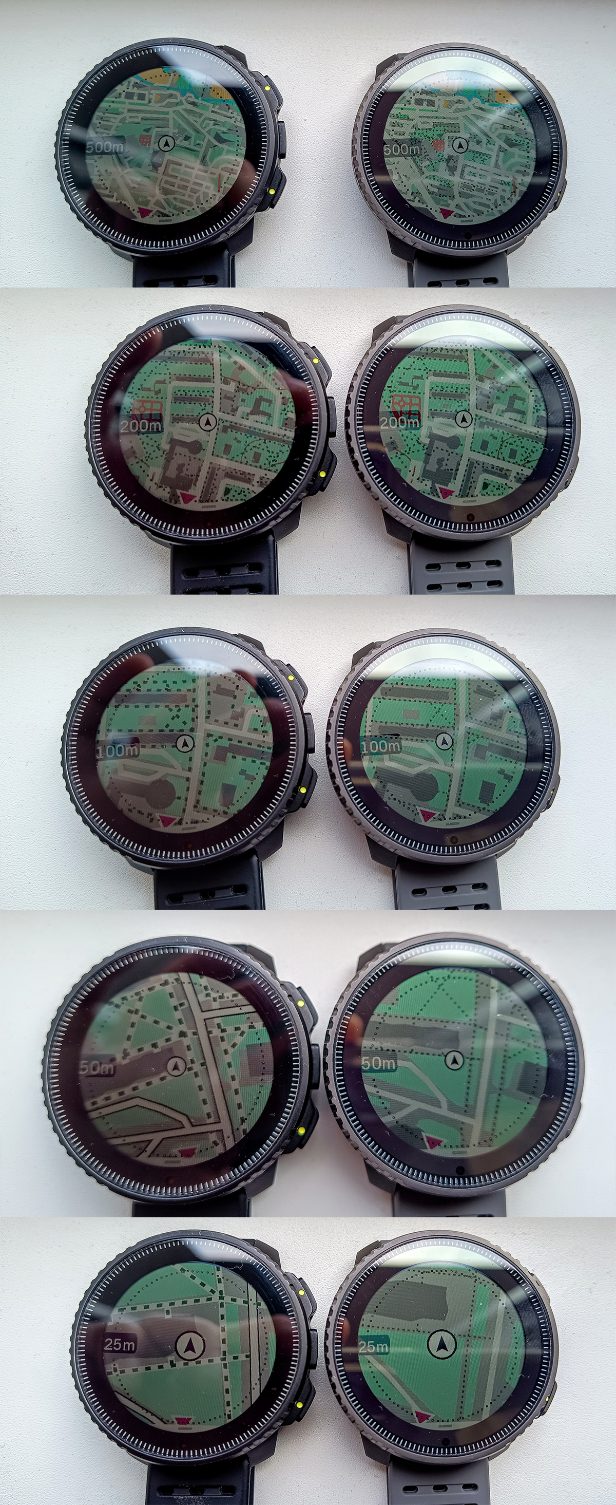
@soisan Are you sure those are trails and not dirt roads? Dirt roads are visible at one level beyond trails. In the USA, when the watch is configured in imperial units, trails are visible up to 500 ft (150m) and dirt roads up to 0.2mi (320m).
But I think even 500m is insufficient. Up until a few months ago I could still see trails at 0.5mi zoom level (800m). And I thought even that was insufficient.
-
I had the chance to experience this issue recently. Was running in the woods, fog all around, and pulled the maps to double check the trails. Zoom over 200 meters and trails dissapear, useless really, I had to pull out the phone maps.
I hope it gets fixed. -
 S sky-runner referenced this topic on
-
This problem will be addressed in the future updates.
Opinions expressed are solely my own and do not express the views or opinions of my employer
-
@pavel.samokha Does this mean we’ll also have map updates for regions that have been waiting for nearly two years?

-
@duffman19 unrelated issues
-
@pavel.samokha said in Map Rendering and Trail Visibility after Software Update 2.43.8/.12:
This problem will be addressed in the future updates.
Glad to hear this!
I’ll order Vertical 2 the day the update is released! -
@pavel.samokha said in Map Rendering and Trail Visibility after Software Update 2.43.8/.12:
This problem will be addressed in the future updates.
This is phenomenal news
-
This post is deleted! -
-
@baaaa trails were brought back to 500m zoom level with 2026 Q1 FW release
Though unfortunately it was not made available for Vertical 1
-
@pavel.samokha and the same goes for Race 1, since it didn’t receive the map-related part of the FW update (or am I wrong?)
-
@SergioB I haven’t tested but I think you should be wrong. Race 1 didn’t receive new map features like titles, but the fix for trails at 500m should be applicable for Race 1 as well.
But again, I haven’t tested and can’t say for sure
-
@pavel.samokha I have to apologize, you are right and I was wrong! I have played a bit with my Race 1 and I can confirm trails are visible at 500m zoom level

Haven’t noticed before, even if I occasionally do some trekking, because after the last update I use a lot the auto zoom feature in navigation, so I stay all the time at 1 or 2 km zoom level, and the the watch auto-zoom near turns
I should have checked before writing, apologies again!
-
I still think it needs to be better.
When map is configured to high level of details, Garmin maps allow trails to still be visible at 1.2-2 km from the current point without panning the map. In part, that is achieved by offsetting the current point towards the bottom on the map screen, so that you can “see” further in front of you on the map. At the same time, usually there isn’t much point at looking behind you on the map.
On Suunto, trails disappear after 500 m when the watch is configured in metric units. It is even worse when the watch is configured in imperial units, in which case trails disappear after the 0.2mi level (320 meters).
Hello! It looks like you're interested in this conversation, but you don't have an account yet.
Getting fed up of having to scroll through the same posts each visit? When you register for an account, you'll always come back to exactly where you were before, and choose to be notified of new replies (either via email, or push notification). You'll also be able to save bookmarks and upvote posts to show your appreciation to other community members.
With your input, this post could be even better 💗
Register Login