Offline Maps and Routing in Suunto App
-
@duffman19 said in Offline Maps and Routing in Suunto App:
@maszop said in Offline Maps and Routing in Suunto App:
I always thought that people buy Suunto watches with maps to use them mainly outdoors, not to find the nearest café in city.
For instance, when I visit a new city, if possible, I begin my trail runs in town to avoid having to drive to a faraway trailhead. Often I’ll need to re-route my course through the city because the streets I initially routed are either too busy or inconvenient to run down. Having a simple, easy-to-read map is preferable in this situation.
There is no routing in Suunto watches (at least not yet), so what you are writing about does not apply to maps in the watch or offline maps in the Suunto App.
As for building outlines, I’d argue they are unnecessary, causing too much visual clutter and (I’d assume) processing bloat, especially on watches. Locations and POIs (bars, banks, service stations, shelters, toilets, etc.) can still be shown as points, but the actual size and shape of the buildings, I think, is overkill. This is one area where Garmin’s TopoActive maps are actually better and simpler since the do not include building outlines, only POIs. And
Building outlines are very important in more remote places. They can provide shelter from wind and other weather conditions, enable wild camping, provide a clue about the presence of water, or indicate that someone might be there with food to sell (e.g., during multi-day hikes), and so on.
Besides, the presence of a building on the map in a remote area is always a valuable landmark.Yes, you can look at everything from different perspectives – it’s more complicated than it seems at first glance. There’s always some kind of compromise.
I’ve seen envy in the eyes of Garmin users when they looked at the presence of buildings, paths, and cliff symbols in places where all they had was a grey background on their map.
-
@maszop if you use watch only for trail running than yes. But suunto watch supports bike too and not just MTB. And if you are on bike trip and you use watch to navigate on your trip. It is usefull to see that you have nerby of your road some place to buy some food, drink or other refrehment. I don’t talk about bike race or any competition, just trip with friends or family. I believe bike trips counts as sport activity too

-
@maszop said in Offline Maps and Routing in Suunto App:
There is no routing in Suunto watches
Yes, I know. I was just referring to using the map to change my path (go down a parallel street, for instance), not actually changing the planned route on the watch.
@maszop said in Offline Maps and Routing in Suunto App:
Building outlines are very important in more remote places. They can provide shelter from wind and other weather conditions
Buildings can still be marked as single point POIs. This is how lots of other outdoor mapping services handle them. In your example of a weather shelter in a remote area, I’d argue this would be better served by showing a shelter symbol POI rather than a generic building outline.
If the downloadable watch and app maps are not going to include POI symbols, then yes, building outlines would be important. But, I would prefer POI symbols as they provide more information than outlines alone.
-
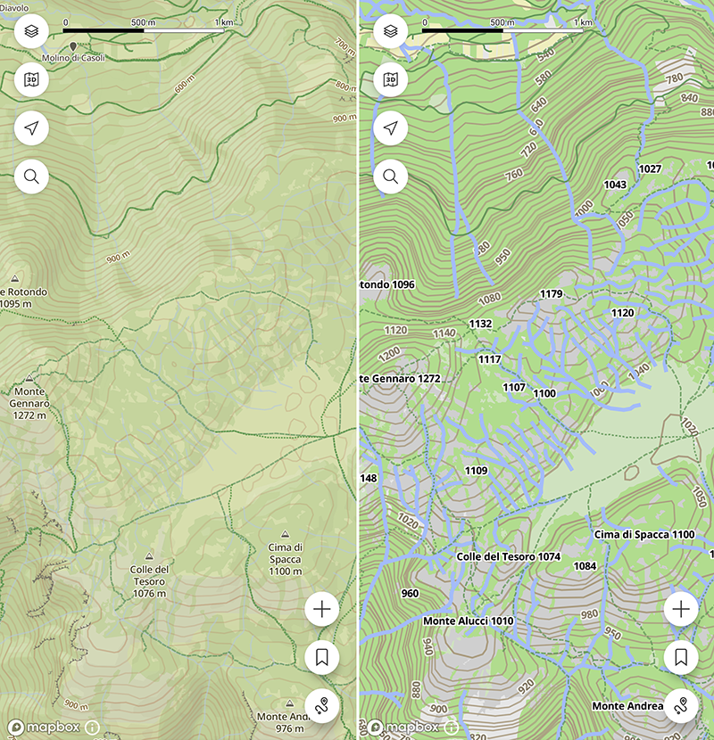
The offline map styles looks a bit too “cartoonish” to me, the lines thickness is larger than the online ones, resulting in a less clear graphic. Here, for example, small water flows (torrents) that are nearly invisible in the online maps are plotted so wide to nearly hide the hiking paths in the area
Suunto Vector . Vector HR . Core . Race & Race S
-
@Tomas5 Well, I’m just not saying we should remove things from the map entirely just because they cause some inconvenience in densely populated areas – because in remote terrain, every element on the map can be extremely useful.
We need a compromise – keep as much information on the map as possible without sacrificing readability.
-
@duffman19 said in Offline Maps and Routing in Suunto App:
@maszop said in Offline Maps and Routing in Suunto App:
Buildings can still be marked as single point POIs. This is how lots of other outdoor mapping services handle them. In your example of a weather shelter in a remote area, I’d argue this would be better served by showing a shelter symbol POI rather than a generic building outline.If the downloadable watch and app maps are not going to include POI symbols, then yes, building outlines would be important. But, I would prefer POI symbols as they provide more information than outlines alone.
I’m referring to very remote places that are poorly marked in OSM – missing proper tags and so on. All you have is the outline of a building on the Suunto watch map. But that alone is crucial information – even without any extra details.
Garmin did not display it because there is no additional information about this place. -
@maszop yes totaly agree with you because of it i suggested above that some type of interest points could be configurable. So if you are in remote location you can show everything. But if you navigate trough populated area you can hide what you don’t need. It could be just list of poi types with on / off trigger in map settings.
-
@pavel.samokha btw is there technical reason why offline and online maps differ? For example offline maps in google maps or in mapy.com are identical to online version if i am not mistaken.
And are this POI/features like parking lots, restaurants, street names, peaks etc baked into map (like hardcoded) or is it layer loaded on top of map layer? Because from behavior it looks like it is rendered as separated layer. If so it should be easy to allow users filter by type.
Suunto Ambit 2 > Suunto 5 > Suunto Race 2
-
@maszop said in Offline Maps and Routing in Suunto App:
I’m referring to very remote places that are poorly marked in OSM
I understand what you are saying. However, in my experience, most locations begin their OSM journey as single points. There are only three types of features in OSM: points, lines, and areas. Streets, trails, fences, cliffs, etc. are obviously lines. Buildings, however, can be marked as both points and areas. Usually, a less-mapped area (like a remote mountain space) will have locations marked as single points because this is the fastest, easiest way to start. At some point in the future, a mapper may revisit the area and add the actual building shapes using the area feature. This can be very time consuming, so it is often not done upon initial mapping.
So, given the above, there could be a scenario where, if only building areas are shown on the map, a storm shelter, having been marked as a point, would not be visible. I see this all around my area. All of the houses in my neighborhood are mapped as areas and are visible on the watch maps, but storm shelters, restrooms, and water fountains marked as points are not.
-
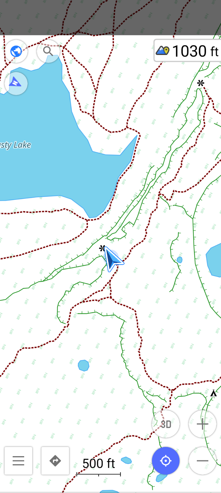
@duffman19 I’m referring to cases like the one in the photo example. The Suunto map shows a line representing a cliff and a building (some RAF station ruins). The Garmin Fenix 8 only has a gray background. Plus some paths, but fewer than the Suunto/OSM.
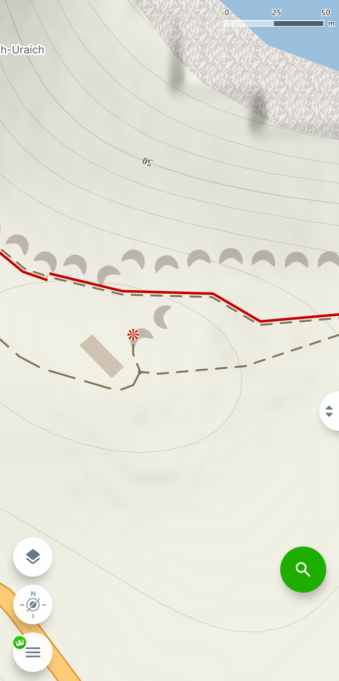
This is just a sample area containing the features I’m writing about. I don’t remember if it was the exact same location, probably yes. A year ago, I compared maps on the Fenix 8, before Suunto removed many details from the maps.
-
@Tomas5 said in Offline Maps and Routing in Suunto App:
@pavel.samokha btw is there technical reason why offline and online maps differ? For example offline maps in google maps or in mapy.com are identical to online version if i am not mistaken.
Different data source
-
@Stefano-M64 said in Offline Maps and Routing in Suunto App:
The offline map styles looks a bit too “cartoonish” to me, the lines thickness is larger than the online ones, resulting in a less clear graphic. Here, for example, small water flows (torrents) that are nearly invisible in the online maps are plotted so wide to nearly hide the hiking paths in the area
As I already mentioned above offline map styles are based on the watch styles and suboptimal for bigger screen, it will be improved
-
@bobbyfw03 it’s really good, to have it back as it already was for years. … so now we can repeat the old request to make the whole route “clickable” etc

-
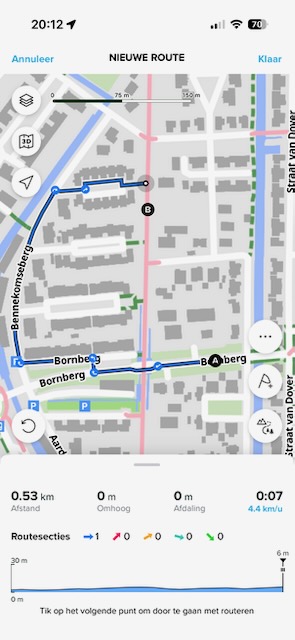
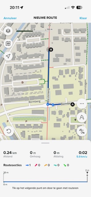
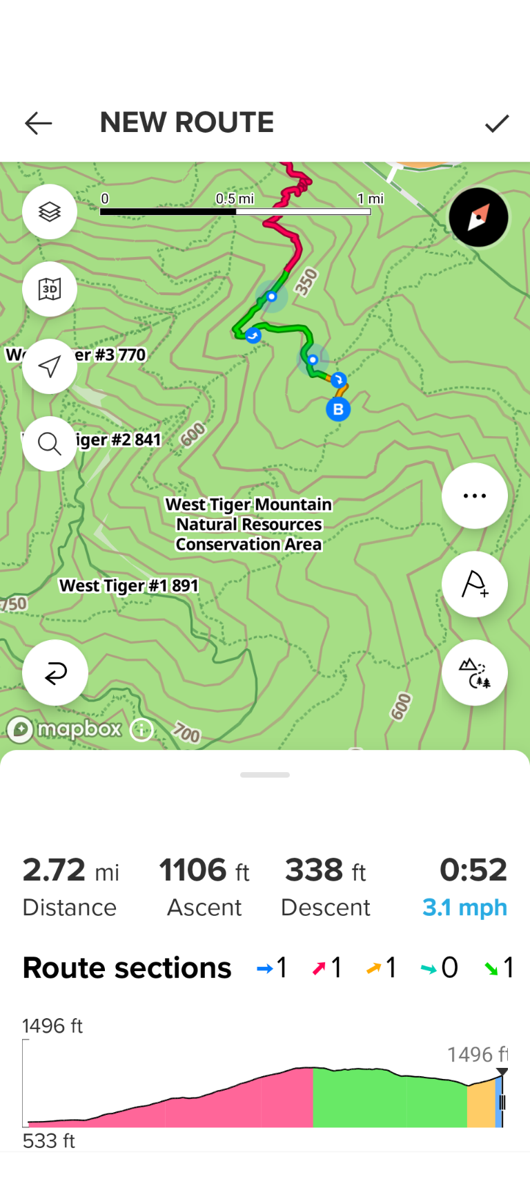
Sure, here are two screenshots of a route created based on the same points and the same route mode (all trails, all roads). One is with the online maps and the other one with the offline maps. The red way is tagged as highway=cycleway in OSM.
Offline maps:
Online maps:
If you need more info, please let me know.
-
@JungleJim yes, location would be useful
-
@pavel.samokha location is in the Netherlands, the coordinates of the starting point A from the screenshots are 52.192754, 5.413624.
-
@pavel.samokha Are there any plans to add the names of the POI if I click an it while being in offline mode? Or at least that I can search for them? When I’m in a new city I like to do some exploration run and it would be nice if I could search for the POI names and plan my route through the city.
Today I can’t get more information to the visible POI in offline mode (this one shows POI „clearer“ than the normal maps) nor can I search for some points I can see on the map in offline. E.g. I’m visiting Rome now and would like to plan my route to the Saint Peter‘s Square- one of the most popular places. I don‘t get a match in suunto when searching for it but can see it in online and offline mode as POI. Are there any plans to expand this kind of search? Edit: Links to pictures -
Poor rendering of offline maps at zoomed out levels - it is almost impossible to see the trail system as a whole to make an intelligent routing decision because trails are obscured by contour lines. I really don’t understand why trails get the lowest priority in terms of readability - both on the watch and now on the app offline maps.
Also, by the way, the altitude is shown in meters on the contour lines even for US users. That isn’t a big deal for me but may be a bigger issue for other US users.
Suunto: Ambit, Ambit 3 Peak, 9 Baro, Race S, Race Ti, Vertical 2 Ti
Garmin: Forerunner 210, Forerunner 610, Fenix 6X, Fenix 7X Ti -
And here is an example of much better rendering of the map that is actually very easy to read on the go - this is OsmAnd app. Also note that most of the app icons are semi-transparent and don’t obscure the map details as much.
-
@pavel.samokha said in Offline Maps and Routing in Suunto App:
@Tomas5 the reverse case is:
I’m somewhere in mountainous not very populated area and I’m searching where to park before going on a hike.
Quite likely there will be also a parking without any explicit tags. Putting it on highest zoom levels will be inconvenient - hard to find, as I will need to scroll a lot.
I’m not arguing it looking overcrowded in the city, but explaining the tradeoffs here. I will think what else we can do
While this may sound practical in theory, I wonder who is using their watch screen while driving a car towards the trailhead.
I think noone.
While driving I use the car’s built in navigation to find a parking spot. So parking places on watch screen is really not necessary.
Thanks for listening.t6, S6, Elementum Terra, Ambit 3 Sapphire, Spartan Ultra Copper, Traverse Alpha, S7 Graphite LE, S9B Ambassador, S9P Titanium, S9PP Titanium, Vertical All Black, Race Titanium Charcoal, Race S Titanium Courtney, Run Lime, Race 2, Vertical 2 Titanium
Hello! It looks like you're interested in this conversation, but you don't have an account yet.
Getting fed up of having to scroll through the same posts each visit? When you register for an account, you'll always come back to exactly where you were before, and choose to be notified of new replies (either via email, or push notification). You'll also be able to save bookmarks and upvote posts to show your appreciation to other community members.
With your input, this post could be even better 💗
Register Login