Live location S+ app
-
Hey @SuperFlo75 ! We’ll expand sms geography nex month, it should cover almost all countries, incl. Germany
Suunto Race 2 Ti
Suunto Race
Suunto 9 BaroSuunto Aqua
Suunto Wings -
 A atoponce referenced this topic on
-
@Nikolai-Simonov Hi, I want to TY for this app. I have an issue, I can’t connect my Suunto apps to your app. I have a suunto race s, my Suunto apps is up to date. Do you know what I am doing wrong ?
-
@Clem__ did you enable the S+ app for the activity you are doing?
-
Which is not usable for any real “emergency” tracking
for real emergency you need a device that doesn’t rely on the mobile network
@Mff73 @Stefano-M64 You’re right: phones aren’t perfect off-grid. A satellite handset (e.g., Thuraya) can fill the gap. The the protocol built with satcom conditions in mind, so it will works well on low-bandwidth connections.
-
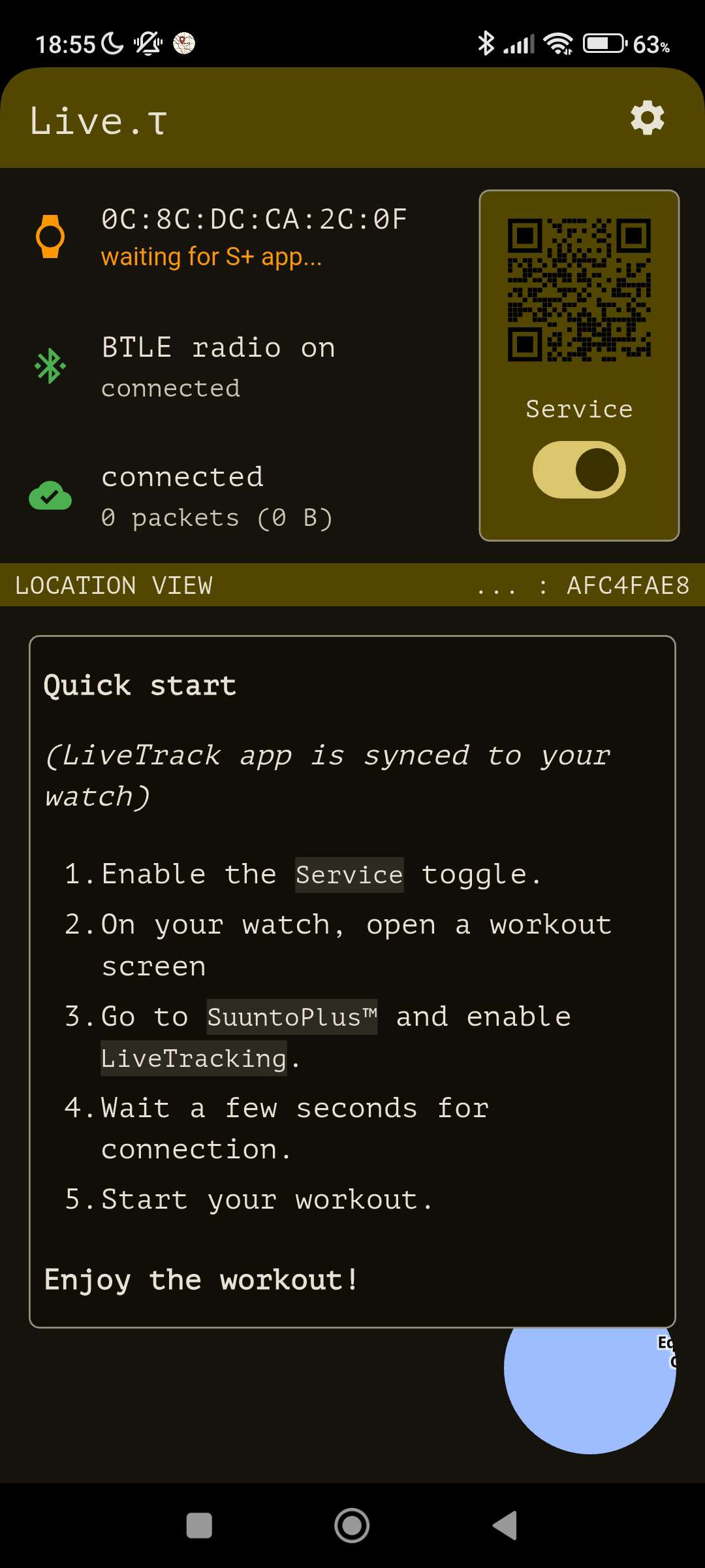
@Clem__ Unfortunately first connection could be tricky, just please wait a few seconds, if not, try to disable/enable the toggle.
It’s it’s knowing issue SA and LT has a concurrent btle connection to the watch more info there - https://forum.suunto.com/post/169252
-
Hi everyone!
TestFlight users might have noticed a few updates over the last days.
I’d like to briefly share what’s new and also drop a small demo video.Routes
• Added snap-to-route: your completed path now aligns with the preloaded route, showing both your actual track and the matched path.
• Routes and checkpoints are now stored permanently.Checkpoints
• New UI for creating and editing checkpoints.
• You can now send messages when reaching a checkpoint (via email & Telegram bot).
• ETA checkpoints are temporarily disabled.UI & UX
• Theme selection is now available in Settings → Appearance.
• Added haptic feedback while waiting for the watch to connect.
• Map view redesigned and optimized for better performance.
• Dark theme redesigned; the map now supports dark mode.Sharing
• Share link now uses a beta. address + code parameter (this will be mandatory in upcoming releases).
• Share link is available only when the activity is started.Other improvements
• Network layering changes (should bring improved stability).
• Minor internal tweaks and optimizations.I’ll be glad to hear your feedback!
-
I like the new features with geofence and most important, that distance traveled is shown in the web interface!
However I think there might be a bug related to geofence. During a short lunch walk with my dog I loaded a GPX route and added a geofence nearby (but circle where beyond my current position. Send message everytime was picked. The app sent approximately 1 email every second. So in a bit over a minute, I received >100 mails.
This bug aside, really nice work!!!
-
@Tomas-Vujic-Schelin thanx for report! I’ll look into it.
So sorry for spam attack on your email 🫣
-
@Nikolai-Simonov Thanks for all of your continued work on this, Nikolai. These improvements are indeed exciting and I appreciate the level of detail that can be utilized.
However, I cannot use the app as it seems to rob the watch from receiving phone notifications (calls, texts, etc.). I posted about my experience above, but have not had anyone confirm whether this is expected behavior or just a problem on my end. I’ve tried the Live.t app on two different phones (one running old iOS and one current), and neither send phone notifications while the watch is connected to the app. The notifications do all come through in a pile after ending an activity, though.
Hopefully this is just a hiccup as having a reliable connection for emergency texts and calls is more important than live tracking for my situation.
Vertical Ti / S9PP Ti / S9P Ti
-
Another thing, which I haven’t seen mentioned above (sorry if I missed it). The map on the shared web interface (not in app), shows wrong elevation on the contour lines. I believe the lines are correct, only the elevation indication on the lines are wrong.
In the area around Chamonix the map shows >13 000m. It seems wrong, otherwise the mountains might have grown since my last visit 🥳
-
@duffman19 Yes, I totally understand the pain the app does block the synchronization channel with the main Suunto app, and I’ve run into the same issue myself. Unfortunately, there isn’t really a workaround at the moment, since the SDK for Suunto watches is very limited when it comes to BTLE.
I’d like to believe things will improve with future firmware updates or if the BTLE SDK on the watches gets expanded, but realistically that’s more of a hope than something we can count on right now.
-
@Tomas-Vujic-Schelin Oh! That’s really strange you’re not the first one mentioning this issue. In theory, the contour lines are pulled from the same sources as many others cartographic projects, so such errors shouldn’t really happen… but I’ll definitely double-check everything.
It just occurred to me - maybe the elevation labels are being displayed in feet instead of meters. I’ll re-check that as well.
-
@Nikolai-Simonov Thanks so much for the reply. Now I know it’s at least not just me. I’ll look forward to the day all the Bluetooths can work together in harmony.
-
@Nikolai-Simonov spero che Suunto implementi questo tuo tool features nella sua principale così dall’app principale non dobbiamo usare un altra app di abbinamento live ma ci basta avere l’orologio sincronizzato e parte già tutto… Suunto integrala nell’app principale! Qui lo sviluppatore ha fatto un ottimo lavoro! L’app funziona benissimo! Certo rimane che una volta avviata l’attività deve generare sempre il link magari sempre dall’app principale Suunto.
-
@emmavet87 Grazie mille per il feedback!
In realtà anch’io penso che sarebbe ideale se questa funzionalità fosse integrata direttamente nell’app principale di Suunto… ma tant’è

A proposito: nella prossima versione (attualmente in fase di test su TestFlight) il link verrà generato nuovo per ogni allenamento.
-
Hello,
Thank you for your app and effort.
Unfortunately, for me it is not usable as long as the process of sending and email every time I start a gps activity is not possible.
Use case : my friend doesn’t know how to use the browser with notifications, bells, etc.
With every exercise, she needs to receive an email with a link to my path, updated every few seconds/minutes, so she can follow me, know that I’m alright, etc.
Thank youX
-
Hey! @treizeXiii so, actually, you can
Just go to
Settings->Emergency contact->Email settings
and add your friend’s email there.After that, your friend will start receive an email every time you start or stop an activity including a link to your live location, and also get a message if you trigger an emergency button.
Suunto Race 2 Ti
Suunto Race
Suunto 9 BaroSuunto Aqua
Suunto Wings -
@Nikolai-Simonov how to Update the App? I cannot see the E-Mail Option
-
@GiPFELKiND It’s been a while since july i guess.
just download latest appstore/playstore depending on os version.The email option should appear in:
Settings → Emergency contact → Email settingsthe email option is shown in demo.mp4
-
@Nikolai-Simonov i cannot find the the Link for the App in Google playstore. I couldnt find it
Hello! It looks like you're interested in this conversation, but you don't have an account yet.
Getting fed up of having to scroll through the same posts each visit? When you register for an account, you'll always come back to exactly where you were before, and choose to be notified of new replies (either via email, or push notification). You'll also be able to save bookmarks and upvote posts to show your appreciation to other community members.
With your input, this post could be even better 💗
Register Login