@dimitrios-kanellopoulos maybe next problem. I have two example of runs - see attach - in March. One is “the fastest” but SA translate it like “the longest”. In CZ right words are “Nejrychlejší” against “Nejdelší”. It is totally different meaning.
Second run is more longer than my “the fastest” run in same months and no “flag/tag” there.!
[image: 1617267747835-01.jpg]
[image: 1617267758926-02.jpg]
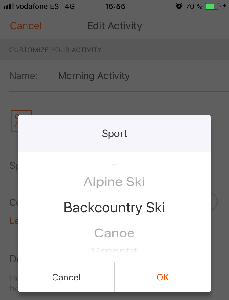
@TELE-HO maybe a language thing? In my German Strava there is no backcountry…
Anyway, syncing ski touring as cross country skiing is wrong…
(In my understanding the difference between backcountry and ski tour is that going backcountry I still use lifts to go up. While on ski tour is skin up.
But am no native speaker…)
@Dimitrios-Kanellopoulos hi, Dimitrios with version 1.13. using iOS 13.2 it is working again. may be an additional infomation it is a iPhone 8plus
Pls send a big thx to the team !!!
After re-installing the app it works again.
Thank you and good you survided the bear!
Case Closed.
@Dimitrios-Kanellopoulos said in Terrain map doesn't load anymore.:
if you uninstall etc? Or try some trick?
I am on Android and can’t seem to change the settings at all? Am I doing something wrong ir is it not active on Android yet? Everything defaults to private.
@fritzbt2013 but the distance matches now right (just making sure pal) ?
Suunto watches do not extrapolate samples. Let me explain:
Imagine you are running and you have 1s recording
You go from GPS point A to B in 30 seconds. That will make it a moving time of 30s.
So far so good.
Now if you enter a tunnel or somewhere the reception is bad then
Point A outside the tunner -> Fused distance in between -> GPS point at the exit of the tunnel.
I think (from my data digging) the Garmin watchs Connect the Entry of the tunnel (point A ) and produce extrapolated coordinates for that straight line (when coming out)
Suunto watches dont do that because that info is generated and not true. So that can affect the moving time agaik.
In short if you have a straigh line you can represent that line with 2 points (4coords) in total (dug) but you could also extrapolate and create a GPS point for every 1second lets say.
I hope it makes sense.