Suunto 9 Picasso Edition
-
@Dimitrios-Kanellopoulos
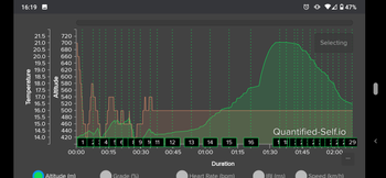
resynced and temperature is back… but not correct as you can see.
temperature went bananas well before the baro did.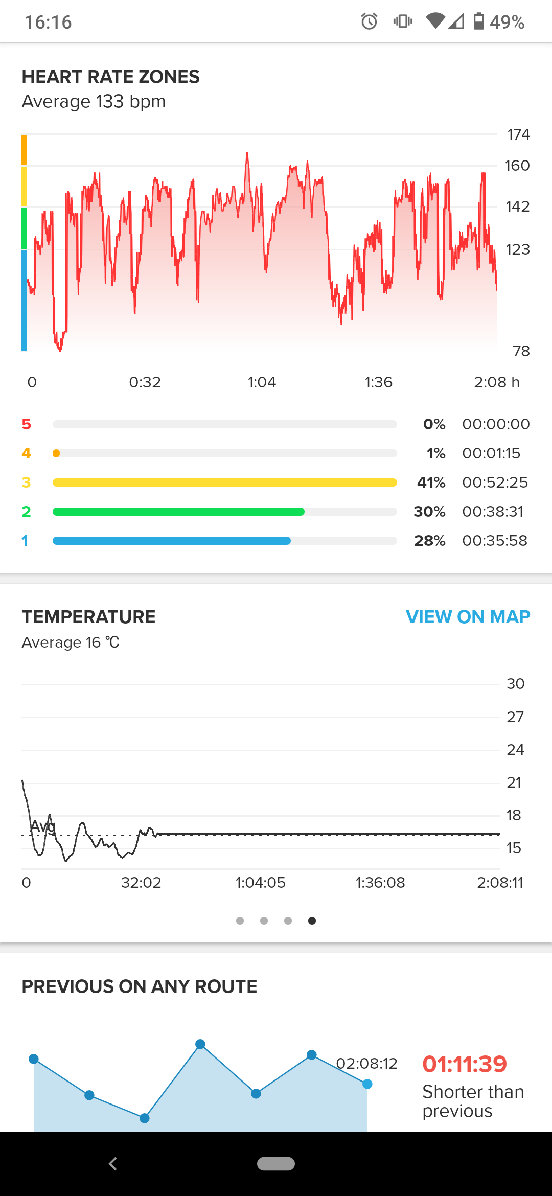
-
@TELE-HO I know this issue. Might sound strange but it might be an edge case that happens rarely. Not 100% sure why but it’s known and fixed afaik
-
Maybe something went nuts on satellite data … This morning my short run on the usual path was 100m off (less)
-
@Dimitrios-Kanellopoulos
means it comes with the next update? -
@Fenr1r said in Suunto 9 Picasso Edition:
@TELE-HO Turn the graph 90 degrees counter-clockwise and play “Guess the Famous Profile”?
That nose… I guess it’s me

-
@TELE-HO not related, but I had an issue with altitude too today

The profile is not wrong, maybe a little hiccup here and there, but the ascent/descent are: I got a 12 up 37 down in the Suunto App. Runalyze recomputes ascent/descent based on the alti data and gave me a more reasonable 48 up 38 down.
-
@isazi
nice, it corrects it?
my recording stays wrong. the value on the watch during the activity was wrong all of a sudden, the graph in SA is wrong, the total ascent is missing 1/3 of the meters the highest point was wrong and the end altitude is wrong, too. And of course it is now wrong in SA, Stravagram (hence Elevate) and QS. At least in QS I would have the possibility to correct it. But I don’t, because then it is not in line with the other databases anymore
-
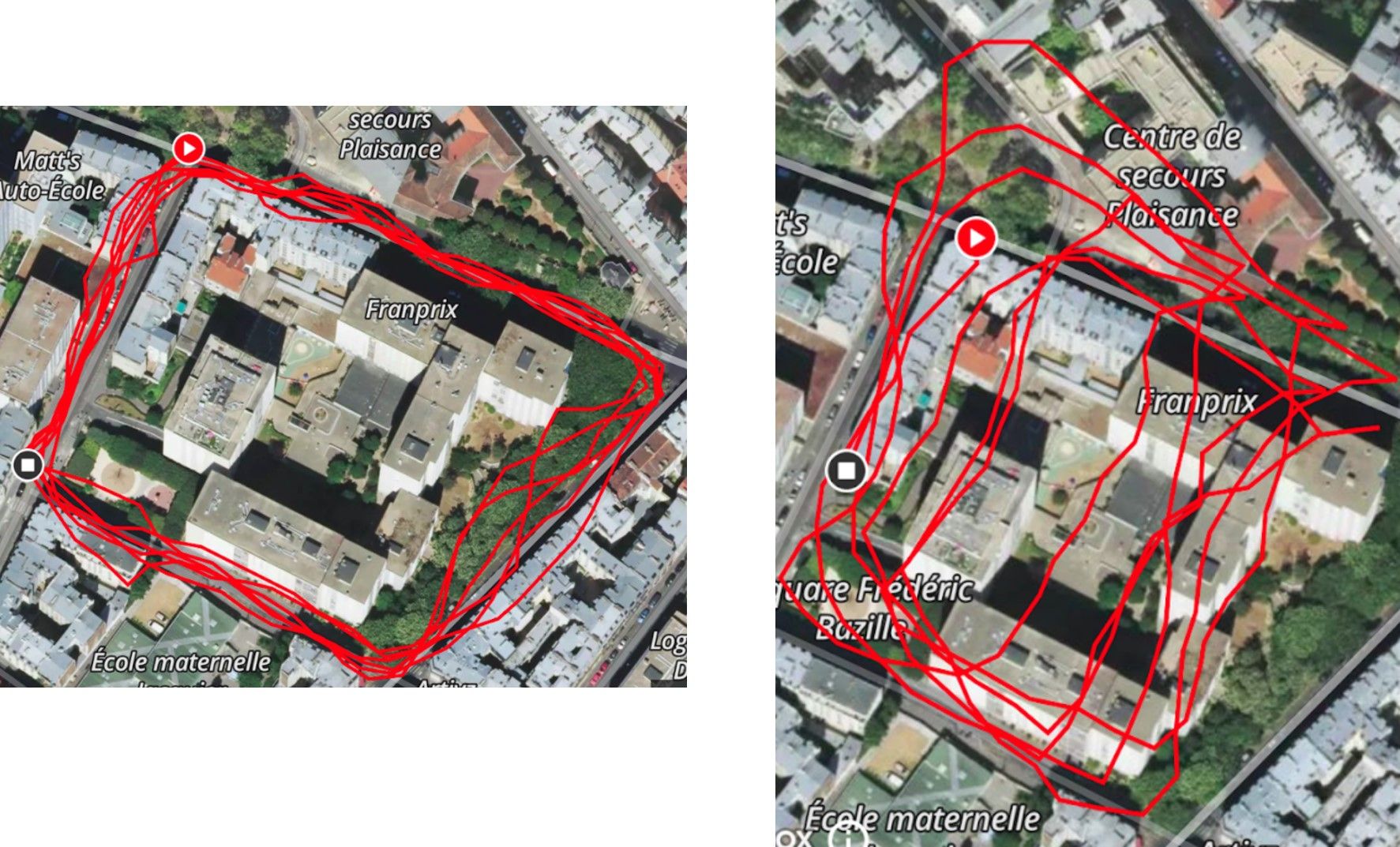
another sad story, the same day, same exercise, left is recorded with suunto app on my phone and right is recorded with suunto9baro.
the distance is 3.3km vs 2.6km…
-
@zhang965
looks like you have a nice phone! -
@zhang965 what says the gps information in the JSON file?
-
@surfboomerang said in Suunto 9 Picasso Edition:
@zhang965 what says the gps information in the JSON file?
Wa-pa-pa-pa-pa-pa-pow!
Wa-pa-pa-pa-pa-pa-pow!
Wa-pa-pa-pa-pa-pa-pow!"
What the JSON say?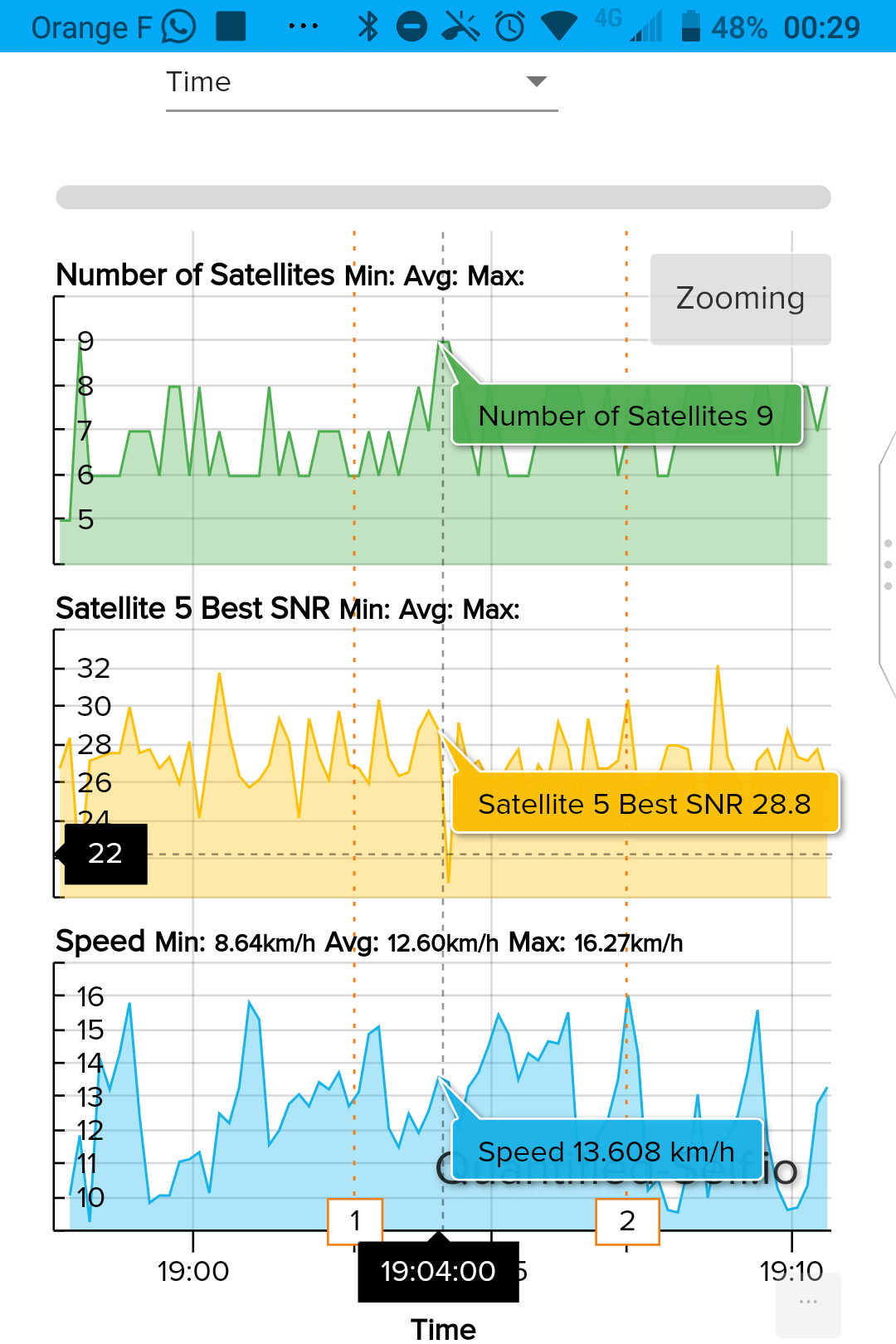
-
@zhang965 Well, it is clear that the S/N and satellite numbers are poor, that explains the poor tracks. Not sure what you can do about that but no watch would be any better with the satellite number and S/N you have.
-
@Brad_Olwin
but why is the phone’s track so much better? Cell location does not do it so much better, does it? -
@TELE-HO power and location in device I think
-
From what I see you start with very little satelites the bare minimum and due to the location I assume it wont improve.
-
@TELE-HO
Basically … antenna -
@Dimitrios-Kanellopoulos said in Suunto 9 Picasso Edition:
From what I see you start with very little satelites the bare minimum and due to the location I assume it wont improve.
It would be nice if the GPS icon on the activity pre-start screen changed its color (yellow/green) according to the GPS signal quality to let the user decide to wait a bit longer or just start.
-
@TELE-HO usually your phone not only takes GPS but also uses cell tower triangulation and wifi signals to improve its location tracking. By using these multiple sources it can get an even better fix.
-
@TELE-HO said in Suunto 9 Picasso Edition:
@Brad_Olwin
but why is the phone’s track so much better? Cell location does not do it so much better, does it?Yes, the cell phone can use towers and any WiFi networks for aiding in location data. The phone likely had a much better fix at start.
My tracks are almost always very good. I am in a fairly rural area, run mostly on trails and I am often above tree line. My GPS conditions are ideal for the watches and I don’t see these issues. Tall buildings, dense forest and deep canyons are much more challenging.
-
@Brad_Olwin said in Suunto 9 Picasso Edition:
Tall buildings, dense forest and deep canyons are much more challenging.
Yes, indeed. Simultaneous tracks:
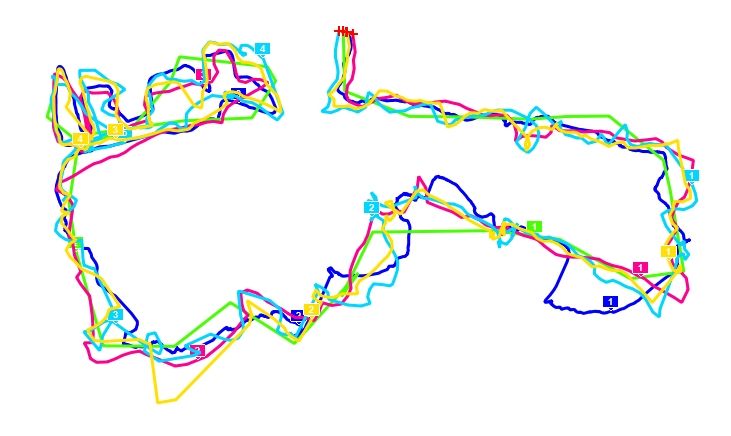
Google Earth measured distance: 3.71km
A3P (light blue): 5.48
SSU (yellow): 4.42
A20 (dark blue): 3.99
i5+Vr (green): 2.96 [Phone + Wireless Data ON]
i7+Vr (red): 3.64(5.17*) [GPS only, Airplane mode, SIM removed]*1.53km of weird westward freakout (5 trkpts) between initial fix and common start.
Both watches on top of pack. Clearly neither happy about it.