S9 Baro Pre-purchase questions - navigation and displayed data
-
@kabzior said in S9 Baro Pre-purchase questions - navigation and displayed data:
- I see in the manual that “Sport modes have their own alti-baro profile setting. You can change this setting in our online account. The options are automatic, barometer only, or altimeter only.” Which option would you recommend for mountaineering?
- How does FusedAlti perform in cold winter in high mountains? Under a jacket, under gloves, does this affect the barometer readings?
1 It’s all automatic and “invisible” now.
2 I always wear the watch under a pair of thick jackets during winter (e.g while skiing) and almost never had any issue with the GPS and the barometer.
This watch had terrible altitude inaccuracies when launched, but firmware after firmware it is now very accurate.
I haven’t noticed any battery duration reductions in cold weathers.And now I wonder whether to create them from scratch with points added, because you mentioned this
It depends on the route. I use waypoints a lot to highlight a cave, shelter of any type, drinkable water and other useful locations during my activities.
is it possible to display on the navigation simultaneously (not necessarily on the same screen) ETA/ETE/distance to the next waypoint and to the end of the route simultaneously?
It is possible and I show them in the same watchface to get all the “time” informations I need in the same place.
I’ll show you a photo of what I use during mountaneering and hiking.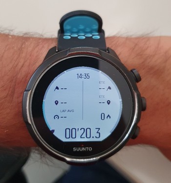
-
@kabzior said in S9 Baro Pre-purchase questions - navigation and displayed data:
ps - and to think I was so close to buying the Garmin Instinct …
Garmin Fenix has some pros like the pulse oximeter, that you don’t really need for mountains lower than 5K meters, and colored maps on the watch, useful when you want to deviate your original route for a new path and you don’t want to put your phone out to read the map. Both not a deal breaker, at least for me.
The Garmin software on the other hand, while better than Suunto because is richer and has way more infos at your disposal, it’s also extremely confusing and somewhat clunky to use. -
@General_Witt said in S9 Baro Pre-purchase questions - navigation and displayed data:
This watch had terrible altitude inaccuracies when launched, but firmware after firmware it is now very accurate.
So it is true that one should by a hiking watch no sooner than one year after it is released…
I’ll show you a photo of what I use during mountaneering and hiking.
WOW, that is outstanding! This will be really useful for me, thanks.
And if you have more points on your track, the watch shows the time/distance to the closest one, and then after reaching it, it switches to the next point?
It is a really PITA that one can not import a route with points in it or edit the route that is already in SA
Garmin Fenix has some pros like the pulse oximeter, that you don’t really need for mountains lower than 5K meters, and colored maps on the watch, useful when you want to deviate your original route for a new path and you don’t want to put your phone out to read the map. Both not a deal breaker, at least for me.
I considered Fenix at the beginning, but firstly I already have a house mortgage
") (and I managed to buy S9B for 1/3 of the Fenix’s price), secondly, I always, absolutely always have a paper map with me, and additionally a phone with an offilne map, so I really don’t need the maps on my watch. I wanted the altitude profile and the remaining distance, hence the decision to buy Garmin Instinct and not Fenix. But Instinct has a lot of problems with the altimeter (and bad barometer placement), and Suunto has that FusedAlti that blows out of the water other watches (like DC Rainmaker’s review, he took S9B to Stelvio pass which is 2760m and log showed recorded elevation… 2760,1m… jawdrop).
(and I managed to buy S9B for 1/3 of the Fenix’s price), secondly, I always, absolutely always have a paper map with me, and additionally a phone with an offilne map, so I really don’t need the maps on my watch. I wanted the altitude profile and the remaining distance, hence the decision to buy Garmin Instinct and not Fenix. But Instinct has a lot of problems with the altimeter (and bad barometer placement), and Suunto has that FusedAlti that blows out of the water other watches (like DC Rainmaker’s review, he took S9B to Stelvio pass which is 2760m and log showed recorded elevation… 2760,1m… jawdrop).At first everyone advised me against Suunto - something still is not working, software problems, general mess … In many reviews too, poor application, not everything is as obvious and simple as with Garmin etc. So I was looking for Garmin. But when I saw this FusedAlti I started to take a closer look. I read the forum, downloaded SA even though I didn’t have a watch, I checked how it would suit my needs. And it turned out that what I wanted works great. Maybe not as natively and immediately as with Garmin (I create a route in Komoot, it syncs with the Connect app and the web version and that’s it), but the gpx import works without any problems (both from komoot and from mapy.cz), creating a route in the application is much better in SA than in Connect, and on the computer for years now I watch everything on Strava anyways (plus I discovered SQ just now). So by putting in a little effort, I got what I think is a much better product that meets my expectations.
-
@kabzior said in S9 Baro Pre-purchase questions - navigation and displayed data:
And if you have more points on your track, the watch shows the time/distance to the closest one, and then after reaching it, it switches to the next point?
Correct
It is a really PITA that one can not import a route with points in it or edit the route that is already in SA
afair this should be available sometime in the future
SVTS - 2.44.46
SSSWHR BARO Amber - 2.8.32
Samsung A5 2016 - Android 7.0
Samsung A33 2022 - Android 15 - One UI 7.0
Suunto App Android 6.3.3 beta
Suunto App IOs 3.4.0 (20552) beta on MBP M1 -
@kabzior said in S9 Baro Pre-purchase questions - navigation and displayed data:
And if you have more points on your track, the watch shows the time/distance to the closest one, and then after reaching it, it switches to the next point?
Yes, correct.
Waypoints are even visible in the route map watchface, that is the one you’ll keep on the watch while hiking, provided you keep the scale under 500 meters.It is a really PITA that one can not import a route with points in it or edit the route that is already in SA
As far as I know they’re working on it and in general to make the process of route creation and waypoints addition smoother and simpler.
It’s still involuted at the moment but somewhat usable.I considered Fenix at the beginning, but firstly I already have a house mortgage
Fenix 6 series is objectively a better watch but it’s not 2 years old like the S9 and I’d not value it 3 times the S9, not even 2 times.
Take the battery duration, S9 is still on the Fenix 6 level and the display of the S9 is brighter and more readable in direct sunlight imho. Altitude reading is also better on the S9.I wanted the altitude profile
That is done very well in the S9.
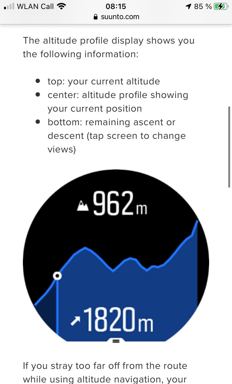
The altimetric profile is simple to read, it shows sea level altitude and the remaining ascent of your route.
Unfortunately not the remaining descent (just the remaining ascent) when you’re going down.Garmin Instinct
S9 is not even comparable to the Instinct.
Sapphire glass, better materials, better battery, better display (the one in the Instinct is so small), better mountaneering functionalities, overall S9 is a tier1 sportwatch, while Instinct is a tier2.At first everyone advised me against Suunto
A lot of people come here on the forum when they have some issue with the watch, and rightfully so, but the problems described are often exaggerated. If you like to be flooded with data, some bugs and a lot of niche features you go Garmin, if you like fewer useful features and a reliable watch you go Suunto.
-
@sartoric said in S9 Baro Pre-purchase questions - navigation and displayed data:
Correct
@General_Witt said in S9 Baro Pre-purchase questions - navigation and displayed data:
Yes, correct.
Waypoints are even visible in the route map watchface, that is the one you’ll keep on the watch while hiking, provided you keep the scale under 500 meters.It’s like Christmas in August
@sartoric said in S9 Baro Pre-purchase questions - navigation and displayed data:
afair this should be available sometime in the future
@General_Witt said in S9 Baro Pre-purchase questions - navigation and displayed data:
As far as I know they’re working on it and in general to make the process of route creation and waypoints addition smoother and simpler.
So, I find process of creating new route or editing freshly imported one on SA very easy and comfortable, so it would be just enough for me to be able to edit tracks saved in SA.
But I found some post here on forum that one can send route with WP to SA from QS and it works… well, it works indeed, WP are there… nevertheless I think just editing would be enough for me, here are my results if this experiment:
https://forum.suunto.com/topic/4682/import-gpx-to-sa-with-waypoints/12?_=1597509783219@General_Witt said in S9 Baro Pre-purchase questions - navigation and displayed data:
Sapphire glass, better materials, better battery, better display (the one in the Instinct is so small), better mountaneering functionalities, overall S9 is a tier1 sportwatch, while Instinct is a tier2.
Oh, did not notice sapphire… nice.
And forgot to mention, I was considering Instinct Solar, not regular Instinct. Not that solar is such a breakthrough, but in this version they added new GPS unit, new HR sensor and power management, so to do Instincts justice it now has better battery than S9B (30h without solar / 38h with solar vs 25h). But it’s all now water under the bridge, S9B should be here on Tue")
-
@General_Witt said in S9 Baro Pre-purchase questions - navigation and displayed data:
Waypoints are even visible in the route map watchface, that is the one you’ll keep on the watch while hiking, provided you keep the scale under 500 meters.
OK, so the watch is here, so far I’m delighted. I do the first tests, as long as walking around the city can be called test
I have some rookie questions:
- The POIs that can be seen on the map and that can be displayed on the watch with ETA/ETE data, can one somehow see their list in the navigation mode (in the sense of how many are left and what is their order)?
- I understand that one can have max 4 screens that can be customized in SA (the last of which is always a map). And the additional fifth screen? Shows altitude profile?
- Is it possible NOT to lock the touch screen in activity mode? Firstly, it would be more convenient for me to scroll the screens right / left as needed, not only in one direction with the middle button, and secondly, I could activate the backlight (because I do not want the auto mode).
- Does the POI-reaching notification in the form of vibration and/or sound depend on vibrations and sounds enabled for other actions? I don’t want vibration when pressing buttons, but I do want vibration when reaching POI.
And finally I would like to sincerely thank everyone who contributed to this thread, thus convincing me to buy this watch model. Praise you, it was a very good choice!
-
Cannot edit any more, 3rd found (custom battery modes) and 4th found in settings.
-
@kabzior said in S9 Baro Pre-purchase questions - navigation and displayed data:
@General_Witt said in S9 Baro Pre-purchase questions - navigation and displayed data:
Waypoints are even visible in the route map watchface, that is the one you’ll keep on the watch while hiking, provided you keep the scale under 500 meters.
OK, so the watch is here, so far I’m delighted. I do the first tests, as long as walking around the city can be called test
I have some rookie questions:
- The POIs that can be seen on the map and that can be displayed on the watch with ETA/ETE data, can one somehow see their list in the navigation mode (in the sense of how many are left and what is their order)?
- I understand that one can have max 4 screens that can be customized in SA (the last of which is always a map). And the additional fifth screen? Shows altitude profile?
- Is it possible NOT to lock the touch screen in activity mode? Firstly, it would be more convenient for me to scroll the screens right / left as needed, not only in one direction with the middle button, and secondly, I could activate the backlight (because I do not want the auto mode).
- Does the POI-reaching notification in the form of vibration and/or sound depend on vibrations and sounds enabled for other actions? I don’t want vibration when pressing buttons, but I do want vibration when reaching POI.
And finally I would like to sincerely thank everyone who contributed to this thread, thus convincing me to buy this watch model. Praise you, it was a very good choice!
-
This can be done for waypoints, don’t confuse with POI, which is a different thing. If you have a route loaded with waypoints you will see these in the map. The navigation will tell you how far to the next waypoint at the start and at each waypoint you will get the distance to the next but it is not displayed all the time, only as a popup.
-
If you have a route loaded you will get the route altitude profile, which I find very useful, this will show the profile, the elevation and the remaining elevation gain on your route.
-
You can set a custom battery mode to your liking and allow the screen touch to be responsive. I personally keep the screen touch off as I don’t find sweaty fingers very precise and don’t want sleeves or rain affecting the screen.
-
In settings you can distinguish between buttons, alerts and alarms for vibration and tones.
-
@Brad_Olwin said in S9 Baro Pre-purchase questions - navigation and displayed data:
This can be done for waypoints, don’t confuse with POI, which is a different thing. If you have a route loaded with waypoints you will see these in the map. The navigation will tell you how far to the next waypoint at the start and at each waypoint you will get the distance to the next but it is not displayed all the time, only as a popup.
Yes, WP not POI, my mistake. I have a route with WP, they are displayed on my map, they are (or rather there is, because it applies to just one, the closest one) also on one of the screens where watch si showing me distance and ETE to that closest one. 100m before reaching next WP I get a notification. So far everything great. My question is: can I somehow check how many WP are left on this route? Some list of those WP?
If you have a route loaded you will get the route altitude profile, which I find very useful, this will show the profile, the elevation and the remaining elevation gain on your route.
Yes, just as I tought, thank you for confirmation, this will be very useful indeed… just now I’m in a completely flat city so could not properly test it and was not sure what it is
-
@kabzior So far no, you cannot check the waypoints other than zooming in or out on the route, which gives you approximate distances as you can see the waypoints on the route loaded in the watch.
-
@General_Witt said in S9 Baro Pre-purchase questions - navigation and displayed data:
The altimetric profile is simple to read, it shows sea level altitude and the remaining ascent of your route.
Unfortunately not the remaining descent (just the remaining ascent) when you’re going down.Just for the record, thing I discovered today - once you have touchscreen activated during activity you can tap on the altimetric profile to change between remaining ascent/descent
-
@kabzior said in S9 Baro Pre-purchase questions - navigation and displayed data:
@General_Witt said in S9 Baro Pre-purchase questions - navigation and displayed data:
The altimetric profile is simple to read, it shows sea level altitude and the remaining ascent of your route.
Unfortunately not the remaining descent (just the remaining ascent) when you’re going down.Just for the record, thing I discovered today - once you have touchscreen activated during activity you can tap on the altimetric profile to change between remaining ascent/descent
Waaaaaat?!?
Going to try it tomorrow. -
@General_Witt yeah, it is in the manual. Sometimes it helps reading it