-
@TELE-HO said in Suunto 9 with the recent GPS firmware was among least accurate GPS watches in today's 25K trail race:
yesterday and today I took short rides and compared on random/different short routes the track accuracies for Switzerland of the different GNSS combination settings…
my takeaway: it is a tiny slightly little bit more accurate with GPS+Galileo but definitely not worth the higher battery consumption.
I did not compare the distance of cours, as all routes are different.… but the activity with GPS+GLONASS has for 100% sure issues with the total ascent…
GPS+Galileo is way more realistic!
I suspect that the baro sensor holes was covered and it caused this pumping effect as I already know from Suunto Core… that’s a huge disadvantage and I hope that I don’t see this frequently. But to be honest, from a design engineer point of view: the location for the pressure sensor is a faulty design
especially when you have to tighten the strap enough to get halfway reasonable OHR readings…with GPS+GLONASS seems have better result than others
-
@vimegar
might depend where you use it -
@TELE-HO It probably depends on location. I’ve heard that GLONASS doesn’t improve tracking much in the USA, and may occasionally result in serious glitches. At least I’ve seen some pretty bad tracking glitches on my friends’ tracks who record with Fenix 5X. Garmin enables GPS+GLONASS by default.
I would play with different tracking combinations more if that could be configured per sport. That would make a lot of sense and would allow using a different custom sport depending on environment. But since GPS settings are global I just leave that at GPS only.
-
@silentvoyager moreover, the best combination may vary by time (of the day, of the year) according to constellation status and visibility of the satellites. So what’s best one day, may not be the best another day.
-
@isazi this.
You can also do some scouting prior to an important workout (a race for example) on Trimble GNSS planning website on constellation availability (you can also simulate elevation cutoff).
Also, Galileo is superior over Glonass since it provides better accuracy (up to 1 meter) on public frequency.
-
@Łukasz-Szmigiel recently found out about Trimble, sounds interesting.
-
I am seriously thinking about going back to using my old Ambit3 instead of Suunto 9.
With the new GPS firmware I no longer find the distance accuracy acceptable on the local trails where I run.Today I did a trail run with a few of my friends. All of them currently use Garmin 5X and their distances were consistent between 7.40 and 7.48 miles. My Suunto has measured 7.11 miles. When I ran the same route with A3P a few years ago it measured 7.47 miles, so it is clearly Suunto 9 is the outlier in this case. The run consisted of a fairly short and steep uphill and a much faster downhill. The uphill part went straight up on a 30-40% slope, and the downhill part had a lot of switchbacks. On the uphill part my Suunto matched other watches, but lost about 6-8% compared to others on the 5 mile downhill.
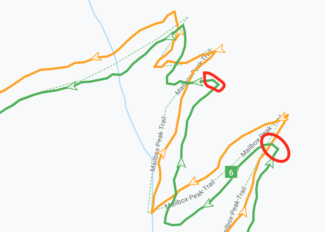
And here is why (this is a comparison with my previous A3P run):

I see a similar picture in a lot of switchbacks. You can see how it stops short before the end of switchback, then cuts through. There are other places on the track where smaller turns are completely invisible on Suunto 9 track.
Here is the entire comparison: https://quantified-self.io/user/JMRgYAdyBBXBsMbxUHGVRwlKoKq2/event/8ntW1ekBcZZMA46TQEC0
@Dimitrios-Kanellopoulos, is there any chance Suunto would consider different algorithms for trail running vs. road running, for example eliminating the 10 meter threshold when saving points for activities such as trail running. Or even better, giving us an option. If the answer is no I’d need to seriously consider an alternative. Fenix 6 is too inaccurate too, but I think that going with Fenix 5X might not be a bad idea.
-
@silentvoyager whow, 30-40% slope … you are machine-like. You actually run at that grade? I would have trouble hiking at 2 km/h at that grade.
-
@fejker said in Suunto 9 with the recent GPS firmware was among least accurate GPS watches in today's 25K trail race:
@silentvoyager whow, 30-40% slope … you are machine-like. You actually run at that grade? I would have trouble hiking at 2 km/h at that grade.
I hiked uphill all the way, then ran downhill. That is pretty normal for trail running

-
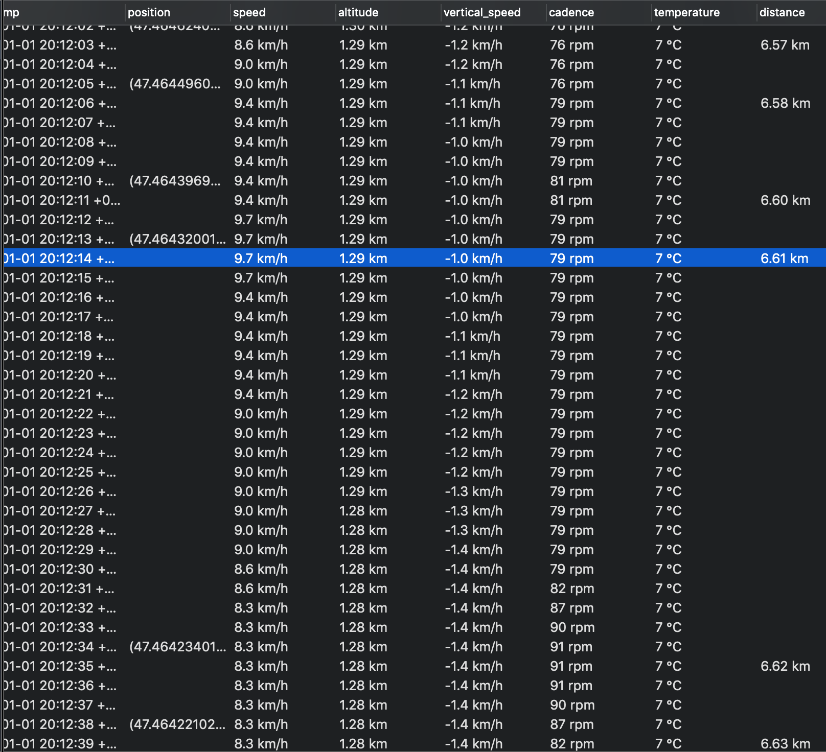
Here is another evidence about how Suunto 9 “swallows” distance on trails - a screenshot from FitFileExplorer application:

This screenshot is from a downhill part of the run I mentioned above. Notice how the distances updates only every 10-20 meters. Normally it takes about 3 seconds to cover every 10 meters. However in the middle part it takes 21 seconds to increase the distance by another 10 meters while speed and cadence remain nearly constant. So clearly the trail had a turn or a series of short switchbacks at that point but from the watch point of view I barely moved.
Where is FusedTrack technology when we need it the most in a case like this? Why FusedTrack isn’t enabled in Performance mode?
-
@silentvoyager hi this is basically one of the last times I am going to mention the distance and fit files or expoorts. I hope it will be understandble for you.
Imagine a tunnel. You run. When the watch determines the distance it will update it.
We could also not write at all the distance at the fit file or exports like gpx export does in many cases.
That said , if from “comparing with friends” is your conclusions based I am sorry to say this is not something valuable or claimable as an argument.
I don’t know what systems they used, were they all in the same arm ? All followed same footsteps ?I don’t even know if you had at the same arm the ambit or different arms and the s9 was on the left , thus taking the short corner from your screenshots.
You want to test better and provide good feedback ?
Wear the ambit and s9 same arm , 10cm at least apart via eg a buff and do a route that has the equal amount of left to right corners.
I will be deploying on qs soon a feature to show the navstar distance as well so you know what is used in terms of fused speed.
So I would strongly suggest to either test right either try not to waste your time.
-
@Dimitrios-Kanellopoulos Thank you for explaining! I get your tunnel exampe. (Although in a real tunnel the watch would start updating the distance from accelerometer once it loses GPS reception, but that is another topic).
What I see on the map and in the FIT is that the position and the distance are updated only when the distance from the previous point increases by more than 10 meters. It is very rare to see two points within 10 meters on any tracks that I looked at. Do you think that is a coincidence that the watch can’t update the position/distance sooner due to poor GPS reception or a deliberate decision in the algorithm, or some combination of both?
I claim that because of that the watch loses distance accuracy on trails.
-
@Dimitrios-Kanellopoulos said in Suunto 9 with the recent GPS firmware was among least accurate GPS watches in today's 25K trail race:
Wear the ambit and s9 same arm , 10cm at least apart via eg a buff…
Given the different antenna placement of the two designs, should one be worn slightly rotated around the wrist/forearm so that the sky views match?
-
@Fenr1r if you have the no bump/patch antenna, then even how the watch is positioned in terms of horizon is important.
assumme “-” is the watch screen pointing to the sky.
/ -> will offset to the left mostly
\ -> will offset to the rightThat is also usually the trend that happens when worn left or right. There is a difference and very noticable.
@silentvoyager I dont argue that the new FW has less distance. A US fieldtester has been pointing this out and he did not agree with the new FW so much.
I will add today later (currently testing ) on QS a GNSS distance stat. Also will provide some insight. I do trails as well, I use stryd. I find it curious that also for me the new GPS FW of the s9 reports less distance but: Stryd always and still reports much less.
I will provide more examples later.
On the good side of the news there is a new GPS FW tested with Beidou as well.
-
@Dimitrios-Kanellopoulos It certainly makes sense: there seem to be around 50 degrees of difference in antenna angle (assuming both are basically in line with the axes of their mounts). That’s a fair bit of sky one of them’s losing if they’re buckled conventionally.
So twist the more comfortably twistable watch so its antenna matches the less comfortably twistable? Loosen strap and stick a little wedge into the air-gap? Or (given that more data is usually better than less, even considering similarly oriented test subjects) just turn the S9 to match the A3P when worn on the left arm?
-
@Fenr1r you could say that that would help. For example, no joke, test done, wearing the watch on the head would dramatically improve reception.
What many people, forget is that the problem is the actual movement of the “antenna” in regards to it’s own axis orientation. Take for example track and field that your arm moves rapidly, walks that you might put the hand in your pocket etc.
Even running and raising the hand to contantly monitor the pace for example, will improve the GNSS tracking. You can perform a simple test via using the routes screen and if you are off the drawn path (eg GNSS is a bit out ) raising the screen to face the sky can improve after a few.
That are my observations from testing and reading, I am not a professional on this.
-
@Dimitrios-Kanellopoulos I agree with you on the Stryd. Mine is consistently less distance on the trails, ones that I have run for many years with many watches.
-
@Dimitrios-Kanellopoulos that is probobly the reason why the bike rides with the watch on the handlebar is always really really good…
-
@nseslija yup
-
@Dimitrios-Kanellopoulos Yup. Got very accurate comparative results once by strapping two to the top of a rucksack. Bugger to tell the time, tho’.
Not just watch angle, of course. Satellites can shift over the course of a race/trek, messing with the accuracy for different people (with the same watches) at different stages on a route. And if a significant number of satellites are low in the the sky, every obstacle in LOS makes a relatively crappy HDOP worse. I seem to remember reading somewhere that it’s not just trees, buildings and hills … enough people between you and a satellite can worsen the accuracy. The sort of numbers you might get at starts or bottlenecks on group runs.
I wonder if the other linked metrics recorded in the FIT files have corresponding levels of (in-)accuracy. Beyond a certain decimal place, extra granularity in any statistic related to distance might be wasted.