your honest thoughts
-
Hello all,
I am looking into getting myself a Race 2. Due to the amount of complaints that I read about HR, bugs, non-matching data between app and watch, sleep tracking and yada-yada, I wonder if that is the general concensus that is is not that good of a watch.I run, hike, ski and bike, hit the gym but dont care so much about those metric. Map is important. I come from a Fenix 6pro. I dont want to pay for a new Garmin with a bunch of features I dont want.
I am looking for a training watch to help me plan and see progress. I aim to do ultras and I am hoping that the R2 would be a good watch for that.
Looking forward to read your responses. Thanks
-
@Sebastien-Trudel I and others here do ultras. Race 2 is a great watch with battery better than any fenix. The only disadvantage is the crown is more difficult to use with gloves. I prefer the Vertical 2 and the flashlight is very handy. There are some bugs that need fixing and an update coming that solves the majority of them. The Suunto watches are primarily sports watches. I don’t care much about fitness tracking or smart watch features.
-
@Sebastien-Trudel
I’ve had Vertical for two months and I’m very satisfied so far. No major issues with the firmware like with F8. Hopefully it will continue that way. Running, trail running (with HR belt), hiking, metrics OK, SuuntoApp much more user-friendly. I don’t miss smart features at all. -
@Sebastien-Trudel
Je trouve l’application vraiment sympa. Je pratique le running avec ma Suunto (avec sur l’autre poignet une Garmin). Il y a pour moi un gros problème avec le Bluetooth et les ceintures cardiaque. Par exemple pour la Polar H10, une fois sur deux la montre ne s’appaire pas avec la ceinture. Si je n’avais que cette ceinture, j’aurai revendu ma Race 2 car c’est inutilisable. Ca se passe mieux avec les ceintures Garmin mais pour Zone Sense les HRM-Pro et Pro+ ne sont pas compatibles (?), la HRM 200 l’est heureusement. En fait le meilleur capteur externe pour la Suunto parmi ceux que j’ai c’est le Polar Verity Sense (mais pas de VFC donc pas de Zone Sense). Il y a vraiment une amélioration importante à apporter au bluetooth ! C’est inédit pour moi des bugs de ce type. Même sur Polar avec qui j’ai eu de nombreux problèmes en tout genre, ça ne s’est pas présenté … Le cardio poignet est mauvais même pour la marche par rapport à Garmin qui lui est fiable c’est + 20 bpm par moments. Au repos, pas de problème (heureusement). Pour l’instant je la garde en espérant une grosse amélioration du bluetooth et l’apport de la musique ! -
@Sebastien-Trudel i have Race 2 for few months, unfortunatelly i don’t do much sport right now.
But at least i can share my opinion:
Build quality is very good, watch looks premium.
Battery life ist good but worse when you enable navigation or even AOD. But it is still good for all day hikes. In smartwatch mode with all 24/7 tracking it provides arount 14-15 days of battery life (when no battery life bug present). Some had worse battery consumption, that bug was fixed but some users claim to have still issues.
Amoled is fine, personally i prefer MIP but in 90% of time i am ok with Amoled too. Just on bike i would prefer MIP much more as enabling AOD takes more battery. It is more personal choice.
OHR works but make sure to keep it firmly to prevent cadence lock. (see some complains on forum)
Software bug i personally have:
I had no issue when bought watch, than firmware update broke bloodoxygen and worsen battery life. Than another update fixed it for some time but after few weeks issue reocurred. Now waiting for next update to see if fixed finally. For now hard reset fixed all issues for me.Map features including navigation are good for hiking or bike trip. I need often calibrate compas but that is not so problem to do.
Customizability is great. You can rearange menu items and hide what you don’t need.
Overall it is good watch with some bugs (but it looks like only some percentage of users have them). If bloodoxygen and powerconsumption will be fixed for good than i would say it is great watch.
Never had different watch than suunto so i can compare to other brands.
-
@Sebastien-Trudel Since you mentioned the map feature being important and other comments mentioning map as being good, here is my obligatory comment that I keep mentioning on this forum about the disappearing trails and other details as the map is zoomed out.
If you plan to use the watch on trails for hiking or trail running, keep in mind that trails disappear from the map when zooming out beyond the 200m zoom level - that is 200 meters from the center of the map screen to the edge. Arguably, that is very little trail visibility as it covers just 1 minute at running pace or 2 minutes at fast walking pace - that is as far as you can see trails on the map without having to pan the screen using touch input, which inevitably leaves smudges from sweat. It is even worse when the watch is configured in imperial units - trails disappear after the 500 ft zoom level, which is just 150 meters.
I’ll keep mentioning this issue until it has been addressed. Also, it is worth mentioning that prior to Race 2 release the maximum trail visibility radius was greater. For example, for watches configured in imperial units it was 0.5 mile (800 meters), which I thought was still insufficient.
Also, I am still waiting for any explanation from Suunto of why this regression in functionality was necessary and if there are any plans to do anything about it. I posted about it here, I contacted support about this issue. I messaged Suunto on Facebook messenger. I got nothing in response.
-
@sky-runner Good points. I’m not satisfied with mapping features of Suunto and I really hope that will change. For my country, last time I got maps update was in December 2023.
-
The last time I used the navigation feature on my Suunto watch in Finland (!!!) it led me via paths that didn’t exist (anymore). And that’s exactly when I was hoping for a nice outdoor experience. I had to grab my iPhone and reroute using Google Maps. I don’t trust the routing feature of Suunto anymore cause I don’t want to spoil another day outdoors.
Suunto 9 Peak Pro
-
@cheetah694 you can plan your “Finnland” trip e.g. with komoot. And import it to your Suunto watch. No Problems with not exitsing ways…

-
@GiPFELKiND don’t both apps, Suunto and Kamoot use OSM(openstreetmap)?
I live in Finland and can tell that Komoot routes are not always the best. If you plan a run in the forest with Kamoot in a an area you are not familiar with, the changes are high that you will end up on such small trails that are barely visible anymore and you most likely have to find another trail
OSM is full of small trails in Finland that are not in use anymore At least in my area where I live and also many places I have visited.
don’t know the situation in other countries though…Vertical All Black
-
@SamuelP But OSM works on the principle that you can fix it yourself. Someone has to keep it up to date – it won’t just happen by complaining and waiting for others to do it.
-
@maszop I know, I have removed many trails in my own area, works well


But yeah, I don’t see kamoot better than Suunto app. They share the same map data -
@SamuelP In my area I have recently removed two such decommissioned trails from OSM. Suunto kept routing me over those two trails because of the slightly shorter path, but both trails didn’t really exist - at least not that I could see. I have just checked the map in the Suunto App and I no longer see those two trails.
-
I have the V2, so a very similar watch and find it excellent.
I walked around Lanzarote a couple of weeks ago, the watch was my only means of navigation and I had no issues with the maps. They are also super responsive and smooth in operations. Better than the last handheld GPS I owned.
I can’t remember having any issues zooming out and loosing trails, I maybe didn’t zoom out that far, but certainly zoomed out more than 200 meters. Could be the Canary Map data is different or the disappearing trails are worse in wooded areas. I had no issues so didn’t really take any notice. I guess I also never lost the trail either.
But in my opinion the maps are very usable. And I also really like the torch feature. I use it much more than I ever thought I would. So maybe something worth thinking about.
-
@Audaxjoe said in your honest thoughts:
I can’t remember having any issues zooming out and loosing trails, I maybe didn’t zoom out that far, but certainly zoomed out more than 200 meters. Could be the Canary Map data is different or the disappearing trails are worse in wooded areas.
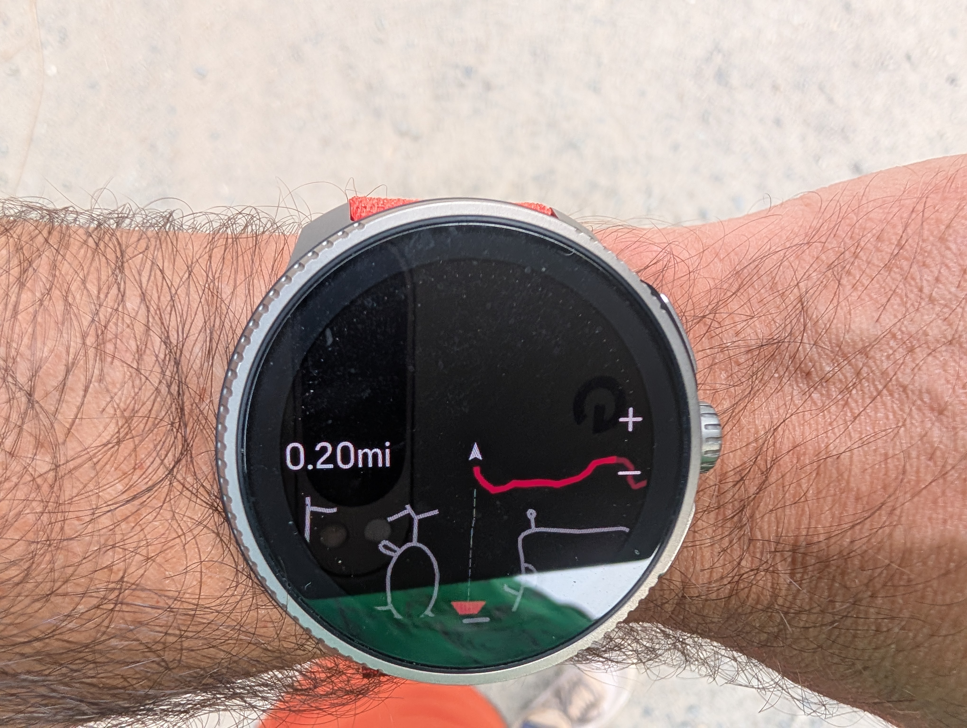
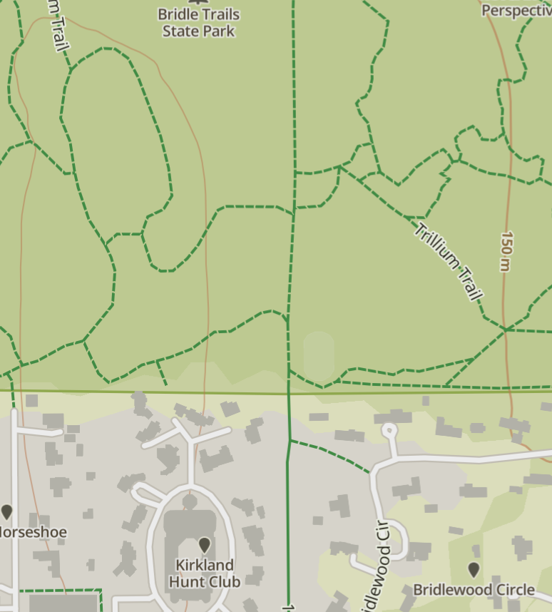
Are these trails shown on your watch as dashed lines with long dashes or short dashes that are closer in appearance to dotted lines? Long dashes are used for dirt roads and perhaps wide footpaths accessible by motor vehicles, and they stay visible on the map for one or two zoom levels longer. Short dashes that look more like dotted lines are used for all hiking trails. Here is I am standing at the entrance of a large nature park with a dense network of trails. There are trails going straight, left, and right from that location. What appears as a trail going down from the center is actually a wide gravel road. The zoom level is 0.2 miles which is just 320 meters:
For comparison, here is the same place with roughly the same radius of visibility in the Suunto App:
Suunto: Ambit, Ambit 3 Peak, 9 Baro, Race S, Race Ti, Vertical 2 Ti
Garmin: Forerunner 210, Forerunner 610, Fenix 6X, Fenix 7X Ti -
@cheetah694 I only use Komoot for planning routes. I then assign them to the watch. That always works perfectly.
-
@sky-runner I’m not sure, as I had no navigation issues I just followed the track, but when I zoomed out a little I didn’t seem to loose any detail that was needed. Maybe if I was lost and trying to find a trail that would be different. I did have a map in my pack for an overview. I haven’t used the watch in mountains in the UK. Only low level walks or cycling on the road. Where the maps are excellent.
Funny really coming from a map and compass background, way before GPS was invented, I found and still find a paper map much more rewarding, it like reading a good book. Just following the watch/gps gets you there but you don’t understand the geography half as well


 ️
️Suunto Vertical
Suunto 9 BARO
Garmin Fenix 3, 5
Suunto Vector -
@Sportsfreund I’m also a Kamoot user. It works really well. Did just have a play with the Suunto planner. It looks interesting but lacks a lot of features you’d get with Kamoot.
-
@Audaxjoe Navigation and map should not be confused. These are two independent layers rendered one on top of another. Navigation can be used without a map as we have done for many years starting with Ambit series. Navigation track is rendered at any zoom level.
Similarly, map can be used with or without navigation. I often use just map for quick exploration of when I know the area in general but may not remember some specific details. For example, here is a fairly common for me case: I follow a trail and I remember that somewhere ahead there is a shortcut to another trail. I don’t have a preplanned navigation so I want to glance at the map from time to time to not miss that shortcut. The problem is that the radius of visibility is so short that I pretty much have to constantly look at the map to not miss that shortcut - I can’t see further than about 1 minute of running. So this kind of on the fly visual navigation is not really possible. Here is another example. Let’s say I do have a preplanned route, but for whatever reason I have to take a quick detour while having the original route in view and merge into the original route a bit further. Again, that is not possible because as soon as I zoom out just a little bit all the trails disappear from the map. So I can no longer use the watch map as a visual reference. This is more common than you might think because detours might be needed for a number of reasons - trail closure, decommissioned trails that I didn’t know about at the time of planning, a need to refill water, etc. To be honest, unless I have a preplanned navigation route and follow it exactly as planned without any deviation, using the map on my Suunto watch often frustrates me. I often have to stop and pull the phone and look at the map on the phone. I certainly almost never had to do that when I owned Garmin Fenix or even when I used Suunto Race prior to July 2025 update. This is the main reason I havn’t upgraded to Vertical 2 yet.
At this point, weighing all factors, Suunto still continues being the best watch for me, but just because it is the best choice from multiple not so good choices. But if Garmin addresses the map rendering and orientation fluidity, I’ll likely switch back to Garmin. Similarly, if Coros releases a watch with a large AMOLED display with the battery life similar to Race 2 or Vertical 2, I’ll switch to Coros because Coros maps are better.
Suunto: Ambit, Ambit 3 Peak, 9 Baro, Race S, Race Ti, Vertical 2 Ti
Garmin: Forerunner 210, Forerunner 610, Fenix 6X, Fenix 7X Ti -
@sky-runner
That’s interesting. I’ve just come back to Suunto from Coros and the maps are better than was available on my first series Apex Pro. I considered the new Apex 4 (which does have better mapping) but I wanted to try AMOLED for better visibility with older eyesight and mapping wasn’t my first priority.
Having said that I would value having more path detail on the wider zoom settings. I’m a fell runner - part of the game is traditional navigation with a map and compass and independent route choice between checkpoints. Use of a GPS device is against the rules except in an emergency.
But at other times, randomly exploring, especially in unfamiliar locations it would be nice to leave the map in the bag and be able to know there was a path on the opposite side of this ridgeline or that a track I’m following meets another a mile ahead. So Suunto yes please from me, I’d like the path detail on wider zoom settings too.
Hello! It looks like you're interested in this conversation, but you don't have an account yet.
Getting fed up of having to scroll through the same posts each visit? When you register for an account, you'll always come back to exactly where you were before, and choose to be notified of new replies (either via email, or push notification). You'll also be able to save bookmarks and upvote posts to show your appreciation to other community members.
With your input, this post could be even better 💗
Register Login