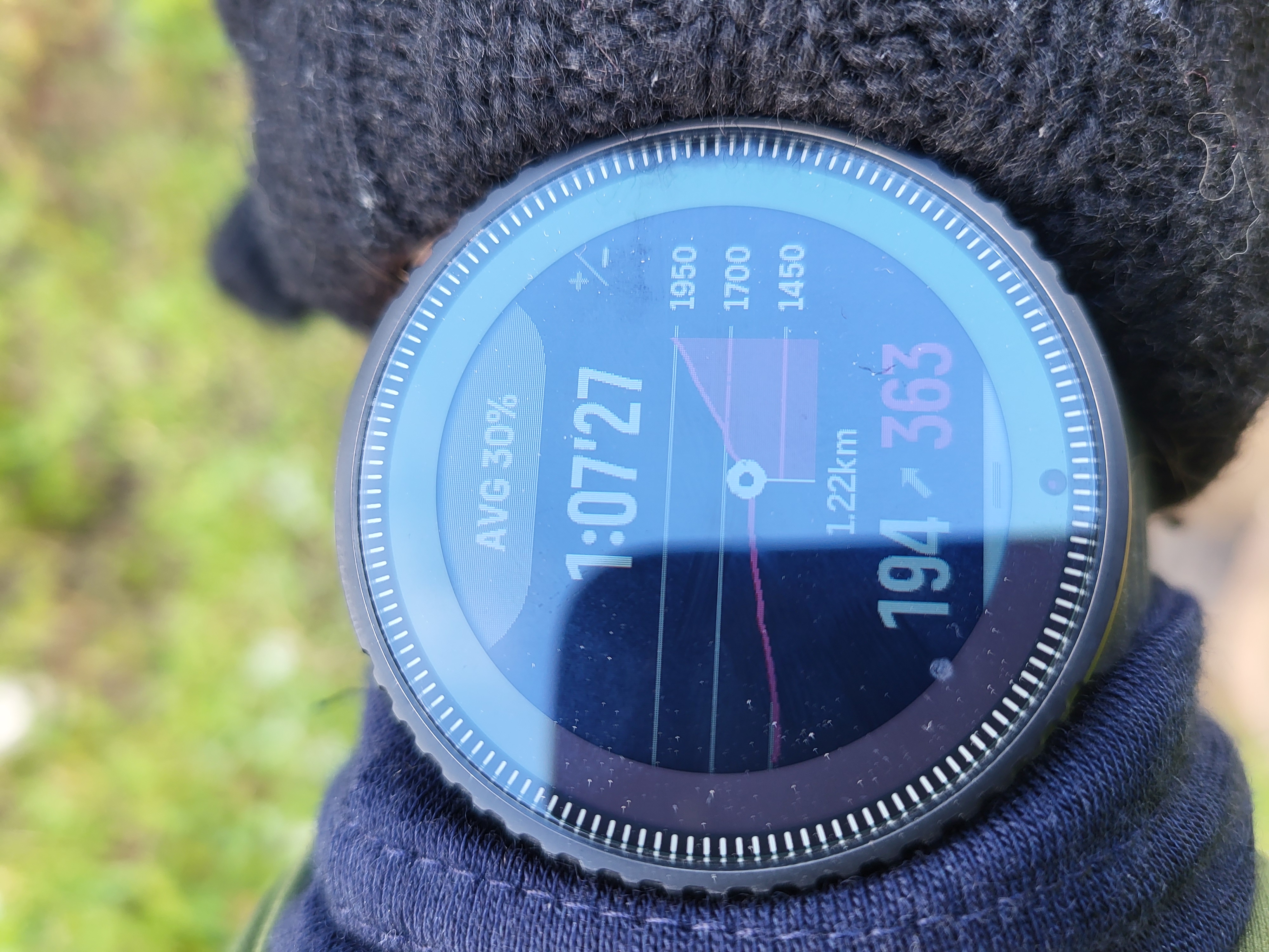
how far or hight to the peak information not calculated
-
Hello
Not sure if the image is from a special app or is displayed normally in the vertical.
But the display only works when a route is loaded. So far no problem.
Now on ski tours it is possible that the situation is reassessed on site and you then take a different route than planned.
After a certain deviation, the watch gives a message that you have strayed from the path.
Unfortunately, however, the display on the picture also disappears and you can no longer see how far (distance as the crow flies and difference in altitude) it is to the top.
PS
distance as the crow flies Translated with DeepL- Suunto Vertical 1, Steel solar All Black and Made in Finnland
- Suunto Smart Heart Rate Belt / Polar H10 (since 27.06.26)
- Suunto Zoop
Android APP: 4.100.4
Linux (Debian) Laptop (No Windows)
-
@vinc14 are you asking a question or just identifying a potential issue? If you are not following/staying on a route that is planned I am not sure how you would expect the watch to know where you are going and what’s ahead…
-
@vinc14 yes, if there is no preloaded route, then there are no climb details - logically. If you go off route then there are no climb details, since it’s following your preloaded route. I think you’re referring to automatic re-routing on the watch, like Garmin does (I think). This doesn’t work on Suunto watches.
-
@larrybbaker @timecode both right yes - but the route still know the endpoint location and altitude.
so I think would be nice - to get the information
lost route
end of route is 140degree 400m ahead and 150m hightit would be also true as close i come to the top it would reconnect to the route loaded.
- Suunto Vertical 1, Steel solar All Black and Made in Finnland
- Suunto Smart Heart Rate Belt / Polar H10 (since 27.06.26)
- Suunto Zoop
Android APP: 4.100.4
Linux (Debian) Laptop (No Windows)
-
@vinc14 you could switch to bearing navigation by using the ruler on the map to pinpoint the summit and add a POI.
I haven’t done this but believe it may do as you ask, other people may know if it would activate the climb guide. I doubt it but you would know the hight your are aiming for, your current hight and distance as the crow flies.
-
@vinc14 as soon as you are back on route the watch will show distance and elevation gain to the summit.
-
@vinc14 A ski touring route is nothing more than a rough sketch that takes into account the destination and available terrain. Deviations from the route are normal, as the best way to ascend or descend is constantly being re-evaluated based on required effort, perceived risk and reward. What may work for biking or running (staying on a predetermined route) cannot possibly work for real ski touring, and when it does, it is the exception rather than the rule.
For example, a flank may not be traversable due to unstable stratification, and the detour over the ridge must be taken. The tour I did yesterday was a prime example of this: avoiding avalanches on sun-exposed slopes as temperature has increased the last few days and chasing remaining powder on the northern slopes. In addition, there were several ascents and descents that made it impossible for the watch to track the route and remaining distance/altitude difference. Your idea of using the location and elevation of the end point to show the ascent and distance remaining simply does not work under these conditions.
In such situations, you need to know the most important points along your route, their altitude and distance. Also, you should bring the official topographic maps to aid in navigation. Your watch can help you with your current altitude. It is up to you to do the math or do the estimates based on the terrain.
The only alternative I see is using POIs to navigate. Bute a data field that displays the elevation remaining to the POI or as part of a bearing navigation display is unfortunaly not available, AFAIK.
Hello! It looks like you're interested in this conversation, but you don't have an account yet.
Getting fed up of having to scroll through the same posts each visit? When you register for an account, you'll always come back to exactly where you were before, and choose to be notified of new replies (either via email, or push notification). You'll also be able to save bookmarks and upvote posts to show your appreciation to other community members.
With your input, this post could be even better 💗
Register Login