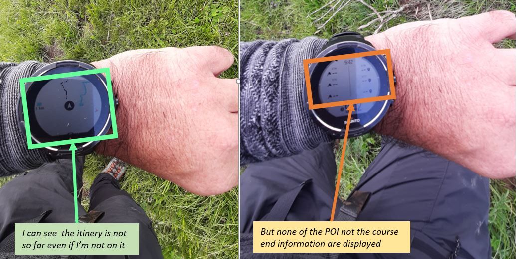
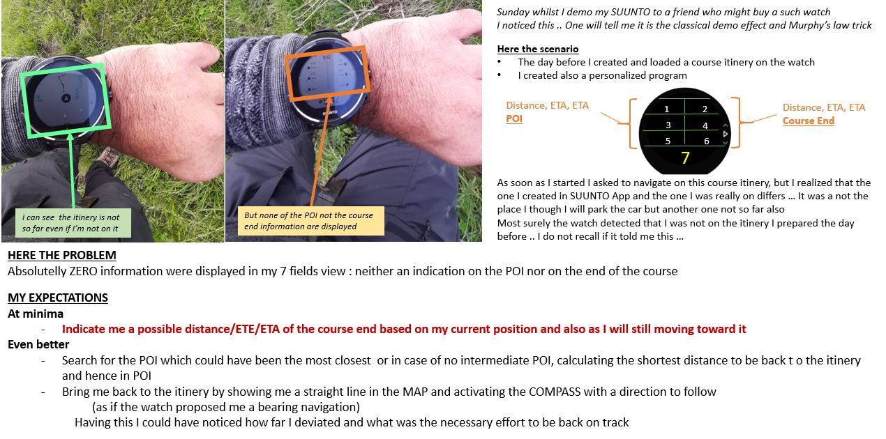
Is it a navigation BUG .. Distance/ETE/ETA remained empty despite I was not far from the itinery
-
I will say, you are right on the fact that watch cannot be specialized for a single given activity
but … I hope you will agree with me that the watch becoming silent just because you are at 200 m far from your planned road in the middle of a big mountain place is a matter of sadness … especially when this watch was offering you the capacity to compute distance, ETE, ETA computation toward POI and itinery ending, bearing navigation, altimeter, etc etcFor me having no more any information until and unless I reach by myself back to the road is still strange.
Imagine that WAZE did this to you … as soon as you see a beautiful restaurant jsut at 200 m from from the highway and you decide to brign your wife here for a good dinner, WAZE will have told you “Sorry man, now go by yourself to your destination, and only when you are on it I will tell you how to continue”

Joking of course, a such watch is not WAZE and it’s also good like that as it allow you to activate yoru brain and think which is the most important in mountain.
-
SUPER MERCI !!!
I will go for it immediatelly -
@mister-pyc honestly, it doesn’t bother me at all. You’re comparing apples to oranges. As I mentioned in some posts above - S5/9 is not an Android-powered S7 - which has maps and has a way better idea about your surroundings (like Waze does).
How can you compare road navigation that applies different route when you change directions (because it has maps and all the data it needs) with an outdoor navigation with no maps and weather data available?

I think that, perhaps, some of the ideas that you’re proposing - that are related to mountaineering and trekking - could be implemented but they would have to be somehow separated from the defaults. Profiles maybe? Seeing how Suunto tends to built its products - I doubt it.
But hey - there’s Suunto+ - so maybe, maybe, your ideas could be refined and implemented as mountaineering aids S+ screen? I think it would make more sense (in certain applications) than “Safe”. And it seems that S+ is just a right place for it to be. But on the other hand - it’s just one screen (but with plenty of automation in the background available and nobody would be forced to use it by default).
-
@łukasz-szmigiel said in Is it a navigation BUG .. Distance/ETE/ETA remained empty despite I was not far from the itinery:
nd we
Humm I do not catch where the apple and orange are

There is no need of any map when you have already loaded a GPX into your APP and transfert it into your suunto watch and you follow it.
if you look to my proposal which was made even better by @дима-мельниченкоHis suggestion based on my initial remark is really excellent and simple.
when the watch detect you are out of route, then why not to switch to this super good bearing mode where the point to reach could be eitehr the begining of the itinery or its end … straigh direct like you are doing if you activate the bearing mode.**Why I do not like the idea of having this addign this as a SUUNTO plus screen ??? **
because you can have only one single SUUNTO screen during an exercise and moreover you should decide of it when you start and you cannot change anymore.@дима-мельниченко proposal better than my initial one : ANGEL MODE
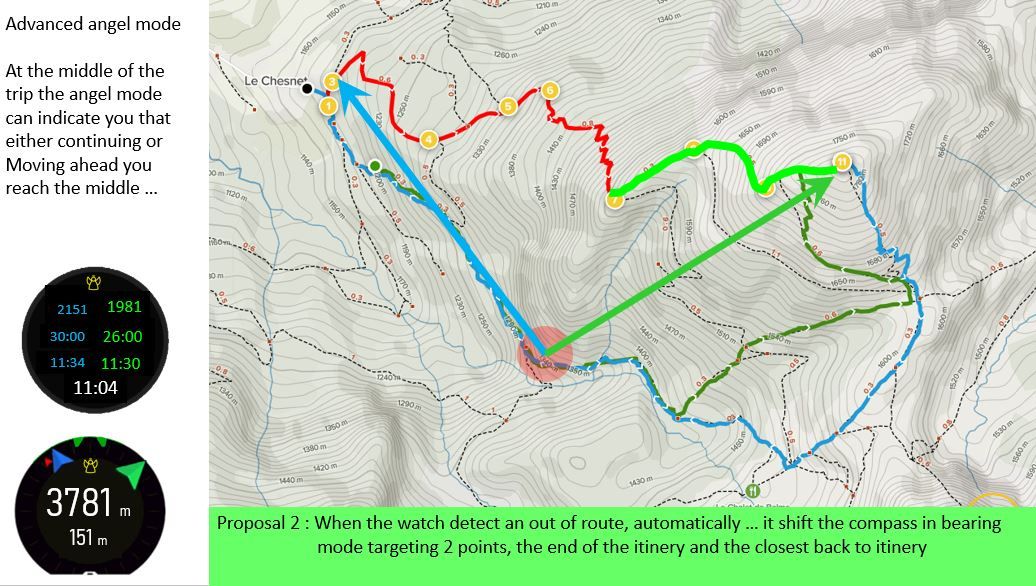
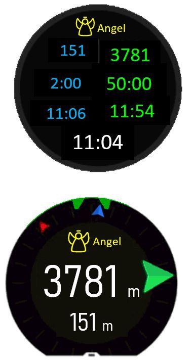
You are no more on yoru planned route, do not worry, an angel is coming to give you some help and telling you how far you are both from your start and end points of your loaded course
-
Always out of curiosity, I know I’m repeating myself, but … based on your last example/image, would you follow the green or the blue arrow ?
I mean, I’m just trying to see the usefulness (and simplicity of use) of all this, from a user pov.
I would say that something like this would be useful if the only direction I get is the one to the latest point tracked on route, that could be anyway not easily reachable (if I just climbed down some rocky slope).
Of course, without considering that breadcrumb can already bring you there
-
Hello Sartoric
Coming back to your remark and after having read the much better proposal from @дима-мельниченко than my initial one.
Imagine that in cas of out of route, the watch is now indicating 2 bearing positions as I was suggesting … but not mine, much better :
- the distance, ETE, ETA to POI is shifted to same but toward Course START point (going straight to it)
- the distabce, ETE, ETA to Itiniery remains toward Course END point (going straight to it).
The beauty of his idea is that the watch is now acting in triangulation mode and you can even locate yourself on the map.
You simply use these 2 points that you perfectly knows like if it was 2 summits that you point with a compass … you just put the angle on the paper map and you know perfectly where you are even in a totally foggy weather.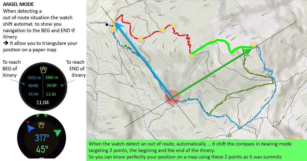
-
@mister-pyc said in Is it a navigation BUG .. Distance/ETE/ETA remained empty despite I was not far from the itinery:
The beauty of his idea is that the watch is now acting in triangulation mode and you can even locate yourself on the map.
well … having a gps and a paper map , I would set the watch datum to the map one , so there’s no need to triangulate using a gps, just reading the position on the screen

-
you forgot the fog

Remember you should think you are in a zero visibility situation.
Otherwise,no need of a such beautiful watch … with one of simple and cheap compass and 2 summits …and that’s itBTW the SUUNTO compas rocks !!! it is perfectly pointing the north


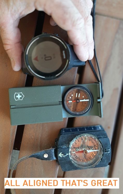
-
@mister-pyc said in Is it a navigation BUG .. Distance/ETE/ETA remained empty despite I was not far from the itinery:
Remember you should think you are in a zero visibility situation.
I hope I can see at least my watch and my map … otherwise I would call the Rescue

-


And your phone so that you can dial the famous 112


Well I already did interresting mountaining activities whilst the fog came in between, just to give you an idea I’m from Annecy, skiing now in La Clusaz since more than 40 years … my skis know normally each moggle individually
 … well well well … one day we were going down from l’aiguille in a total foggy situation, 2 tourists who were totally lost asked us where to go to reach the ski ressort, I told them follow us,…
I was 200% sure precisely where I was … came a pylon …
guess what … I knew I should arrive to it … except … it was the one above I was thinking


All this in a ski ressort I know by heart … totally by heart -
@mister-pyc I have been in multiple white out conditions Ski Mountaineering at high altitude ≥4000m. I am sorry but the last thing I am looking at is my watch. With the wind howling around us and unable to barely tell which way is down, my partner and I would ski together for 20-30m and then stop and again and stop… When necessary we pull out the phone and one of us will check to see if we are on course or near it. I just would not have use for the watch under these conditions, the screen is too small and will not help me to avoid cliffs or avalanches.
-
Humm humm humm do not blame so much your watch to have a too small screen


 … I also hope one day the 30% of remaining black space will be used by a future model … which I will immediatelly buy (also because I will even see worth than today)
I was many times in similar conditions and in fact the watch was still super interresting to be here. For sure and you are right, it has to be considered as a gadget and not a definitive reliable safety system, still it is a wonderful tool.
For example : when you think the weather may become foggy or white out as you said (btw super nice to discuss with you as I learn new english terms,btw we say the same in french “jour blanc”) before you reach the refuge and still you want to engage the summit … what we generally do, will leave the back packs all together at a certain position that we mark with our watch (it happened that left them in the middle of a glacier), then we do the rest of our climb to summit much faster to still reach it as fast as possible … and if the fog or white day effectively come, we still are safe as we know that the watch will drive us quite preciselly back toward the back packs … of course I agree with you that we do this trick only when we first of all have a good visibility from here to the summit and we see that there is no such cliffs or dangerous crevasses between the back pack and the summit…
Skiing lot of times with guides in chamonix who are friends and quite well known I can insure you that they are using their watch …
What I’m telling you is a true story … meanwhile we were engaging the summit, half of the group was too tired and decided to join directly the refuge … the matter of fact is that, even having done this we arrived before them thanks to the fact in the watch there was the POI of the refuge and some crucial place to reach before … and we were never lost even if we were almost not able to see the beg. of ours skis … when we arrived … there were no others skis outside … so the group which should have arrived before us was lost … the guys were not havign put any POI on their watch and despite they start earlier when the white condition were nort here, they still loose themselves in a much small area than us …PS : no watch will never avoid avalanches … only you and your caution and knowledged of them and how to stay safe. personnaly I always ski thinking I do not have a DVA … going that way I take strict minimal risks (risk zero never exist) but I’m super hyper cautious … 40 years of ski in deep and steep slopes in Aravis … I have been taken just one time … and I was a young and imature guy at that time
-
@mister-pyc I have been skiing for 60 years, never been hurt and have done a lot of Ski Mountaineering starting in the early to mid 1980s. I have skied on a lot of glaciers and in mountains that do not have glaciers. I do and have done a lot of steep skiing and have a significant amount of avalanche training. So, I stand by what I said as it is my experience. We have few to no refuges in the US. I have never used one.
-
If one day you come nearby Annecy, please contact me, be my guest for one day. It will be a pleasure to bring you in la clusaz and some of the beautiful “off piste” that really are marvelous.
Concerning the watch … in fact I will come to your point … it is the first time I have a such powerful and beautiful watch … to be honest … most of the time, I prefer to not rely on any such electronic devises … just because as I’m a stunned guy … either I will have forgotten to load the POI or to charge the battery.
Still I was impressed to see how a watch, far more basic that this 9 BARO was able to drive me back to a super precise point … it was when we did the “Haute route” between Chamonix and Zermatt … and really that day I though whaouuuuuu !!! -
@brad_olwin said in Is it a navigation BUG .. Distance/ETE/ETA remained empty despite I was not far from the itinery:
We have few to no refuges in the US. I have never used one
Brad
What is hte meaning of “We have few to no refuges in the US. I have never used one” ?
I do not catch the sentence.There is no refuge in the US ?
my be I’m using a wrong word … I was speaking about mountain huts.
Here in the alps there are lot, and very often we spend a full week around the 4000 to find the best snow … either navigating around one single “hut” or moving from one to another which is also very interresting -
@mister-pyc We do not have many mountain huts. There are a few in Colorado but most have to be reserved. On my trips when I am overnight I use a tent.
