Is it a navigation BUG .. Distance/ETE/ETA remained empty despite I was not far from the itinery
-
If you are off route how the watch could know how long would it take for you to get to a point on route? It does not even know if there is a path between you and the route.
Watch: Suunto Vertical 2 Titanium Black
Blog: isazi's home
-
@mister-pyc just because something can be done doesn’t mean it should be done. The beauty of Suunto watches is in the simplicity and the design - things are rather well thought out and the brand doesn’t just add features mindlessly for the sake of having them (because marketing).
There is a certain wisdom in it, especially in regards to automation. Yes, you can automate many things but the more you do, the more things can go wrong and the harder it gets to debug and make a solid product people may actually rely on in the field.
I’d rather have a manual switch between POI / compass / route that works than an automation that is unreliable. Or an automation that is very hard to understand in practice and may not suit everyone’s needs.
Also, keep in mind we’re talking about S9 that is not a smartwatch but a sports watch with embedded OS with different capabilities than ie. S7 running Android. What you’re proposing might be easier to develop and maintain in such platform than on S5/S9.
S9PP 2.50.28
-
@mister-pyc said in Is it a navigation BUG .. Distance/ETE/ETA remained empty despite I was not far from the itinery:
==> FIRST OF ALL AND THE MOST IMPORTANT : DON’T YOU FEEL IT IS A BUG THAT THE WATCH WAS UNABLE AT MINIMA TO INDICATE ME THE DISTANCE, ETE, ETA OF AT MINIMA THE ENDING POINT OF THE ITINERY
Nope. Not a bug. An absent feature or bunch of features compared to other watches but ones deliberately left out of the S-Series, possibly down to restricted FW space or maybe coding time/cost or perhaps just product differentiation from the Ambits. Or other.
(Very accurate Route stats and clever direction indicators were the replacement. It may be that the two systems are sufficiently different and demanding that the watch cannot load both into memory at the same time.)
FWIW, in Suunto/Forum-speak a “POI” exists on its own. The named points on routes (+Beginning and End) are “Waypoints” (WPs) not “POIs”. Things can get confusing when the Point names and navigation styles start to blend in discussion.
-
@łukasz-szmigiel I agree on the automation point: which routepoint would the watch pick? Closest by distance even if it’s behind you on the route? Optimal convergence forward to end point of route (tricky if it’s a loop)?
However, I think having the choice between WP and routepoint navigation, at Route-saving or -loading or even mid-exercise would be worthwhile for those in the not-necessarily-mindful but still potentially lucrative (see G*****) AND outdoorsy-credible wilderness-roaming market.
-
@fenr1r automation is good if done right. It’s done right if designed well. Which is the hardest part I think.
You can always hire more developers to write software but really great ideas that just work are hard (and therefore rather rare).
As far as ETA goes, good example of how hard it is to design (and automate) what I’ve learned recently is this.
Ambits are not my era but perhaps someone someday decided that the S line is to be simplified, hm?
-
@łukasz-szmigiel said:
As far as ETA goes, good example of how hard it is to design (and automate) what I’ve learned recently is this.
I thought that was interesting but possibly running against the very Suunto focus on enforced maximum accuracy-while-Navigating (as opposed to -navigating) that gave the S-series routepoint Navigation and plausibly set up that apparent oddity.
Call it Presumption of Precision, perhaps.
Put another way … I’m not sure Suunto want to deliver ETE/ETA/Distance numbers based on anything less than the best they can do. As @Brad_Olwin has often pointed out, the low-frequency GPS fixes make those numbers waaaaaaay off. FusedTrack and Snap-to-Route work their magic retrospectively. Midway, and with anything other than a straight-ish route (where the error factor might be a constant-ish calculation against the few fixes), you’ve got problems.
I’m all for user responsibility in acceptance of dodgy stats but I can also see Suunto saying “Nope: that’s really not our brand”. As pretty much everyone points out, however, the implementation is a bit of a mess.
Ambits are not my era but perhaps someone someday decided that the S line is to be simplified, hm?
Absolutely (in Route-following UX terms). The occasional counterintuitive precision-over-battery-life(/UX sense) priority moment isn’t a wholly a new thing, I discovered. Back before your time, sonny, the default Trekking (i.e., longest endurance) Mode in the Ambit 3s was tweaked by FW revision to use Best GPS. Over-enthusiasm for accuracy in all things, perhaps.
-
@fenr1r I won’t argue about poor usability of ETA when there is not enough data available (either when stationary, not on route or on endurance). It makes sense to provide no information instead of very inaccurate information.
What I find troubling in this particular example is “enforcing”. This is an oversimplification of the interface and the problem which leads to unforeseen consequences for the unsuspecting user.
S9PP 2.50.28
-
I may agree with you
… but …Still let’s make a proposal
If the watch detect that you are off route why not having it to propose
option 1 : bring me back to starting point
option 2 : navigate in bearing mode to the end pointHaving done that will result into 2 big advantages
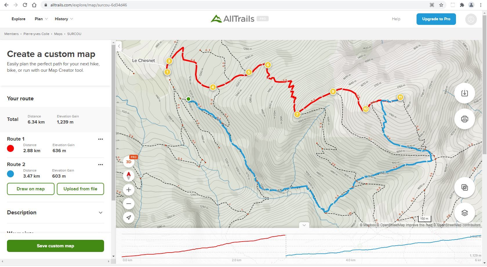
- when you start your journey and realize you are not precisely on you route, then the watch indicate you how to reach it … if you see my example it was a matter of few 100 meters …
- when you say OK I don’t are so much to be back to my itinery, still give me the details to reach the summit … if you see my example, as far as I was progressing, this indication will become more and more accurate and at the end I was back to my planned route, so became totally correct.
In reverse, what I observed was that almost until the end, the watch became totally useless … she was lost …
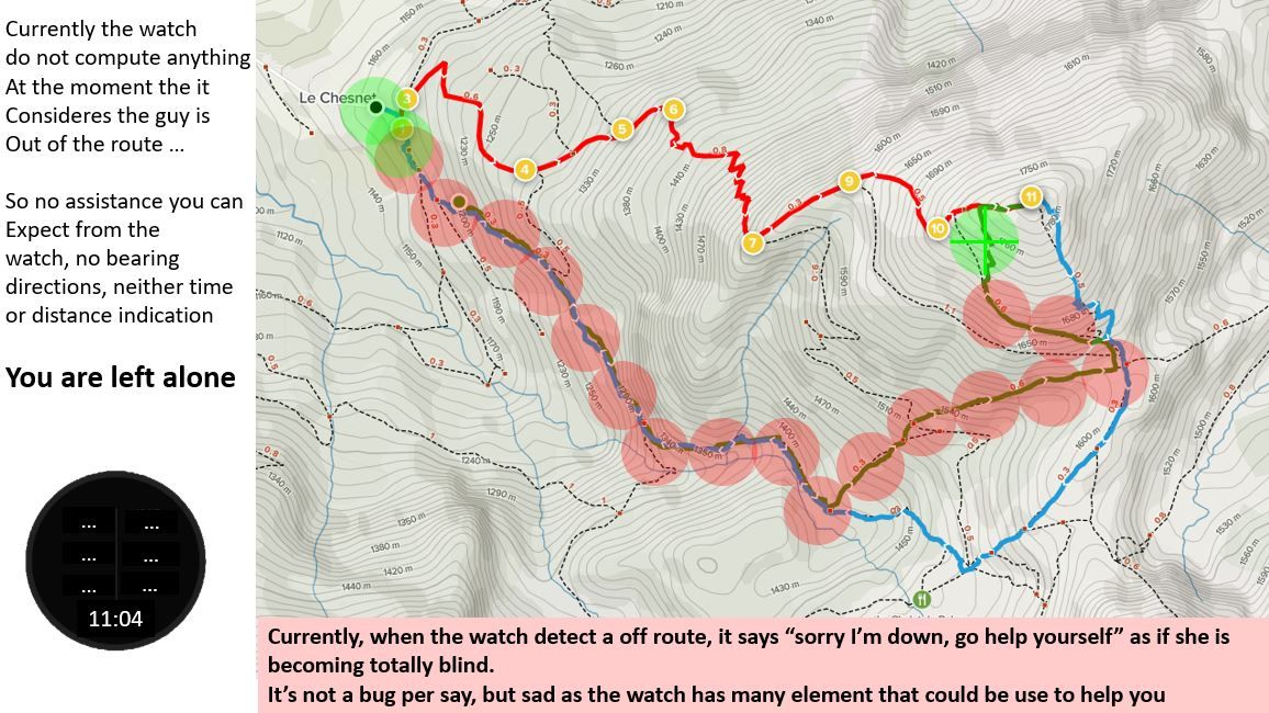
In the drawin :
- in red the theorie
- in blue what I did
At the last 500 m, I stopped the navigation on the itinery and switched to a navigation to a single POI as I also memorized fortunately the summit as a POI, this just to control that the watch was still able to compute distance, ETE, ETA and it was not a bug.
As you can see, if I was in the fog, the watch will have been useless if I was not also saving some POI on top of this route.
-
hummm
I do not agree with you.
using this watch in mountain, I would have been impressed if it was a sheepdog that may help me. here the watch was lost where some simple things could have been dog.
you have to imagine yourself in a totally foggy situation … in such a situation you may walk nearby the refuge just 10 meters and even do not see it.
I agree with you that in such a case, you will have also record the refuge as a single POI and so … cancel the itinery and switch by yourself to a bearing navigation to this point.
But … still … not being able to give distance, ETE, ETA at minima to the ending point in a straight bearing navigation when the watch realise that you are off route, for me is an error.
-
@fenr1r said in Is it a navigation BUG .. Distance/ETE/ETA remained empty despite I was not far from the itinery:
te stats
You are very right its not a bug per say, but an absence of feature.
-
Humm humm humm …
I think we are going wrong here
Let see it in another angle :
you have a refuge as the ending point of your course, you have to reach it safe. this is the traditional goal of a course.
Let’s take 2 people :
- you build an itinery to reach it, but you forgot to mark it as a POI
- I just store it as a POI
you start your journey, did a small peak in between … the watch now realize you are out of your itinery and give you no more any indication …
you are in the fog … you are a potential dead manI do exactly the same and when the fog come I activate the navigation toward this POI … still the watch help me
Of course and here I will totally agree with you, the straight directly route in mountain is generally absolutelly not a good one, especially when you are on a glacier or nearby cliffs … but at least the watch give you some help to know how far you are from your safety point.
So, my point was JUST …
when the watch realize that it is of course, why not she switch automatically to a bearing navigation mode straight to the end place of my itinery … it will not be different from the navigation to this POI, so there is no errors here.PS : I already slep a full night in hard condition at just 50 meter of a refuge and we were unable to find it … when we wake up the next morning and realized the fog dissapeared … we also realized that the refuge was here just in front of us … but during the run we were unable to see at more than 5 meters and it was such bad that we dediced to stop as soon as we found a big rock to stay a little bit sheltered by it.
I’m writing the post, thinking precisely to this situation. If by error I had forgotten to also enter the refuge place as a POI, the watch will have been of no help until I came back into its itinery area …
-
@mister-pyc you are mixing ETA with navigation features.
If you are off-route the watch won’t show you ETA but you can switch to navigation screen and still see your waypoints and the direction you’re heading.
In such case you’re describing - being in a dense fog 50m from safety - the watch won’t even trigger off route warning as the limit is 100m I think.
You could have easily go to navigation screen (if navigating a route) and continue to safety. Even if off route. Also, zooming is dynamic when off route and the watch will try its best to show you at last the closest part of your route in relation to your position. It’ll zoom in as you get closer to the route.
-
You are right, but still something a little bit more helpful simple could have been made which I think is easy (as the ending point is well known and part of the route loaded on the watch)
Rq ! in my example each circle as a 200m diametre. so you can see almost all the time my watch told me “out of route” and did not provide me any help … frustrating …
BTW
- think to it as if you were in the SUUNTO marketing team, you can sell it as a super argument … you get lost out of your route, do not worry your companion watch will not leave you alone
- think to it if you were positioning a ending POI or in reverse if the route you created on paper is in fact a impossible one (you did not realize on the map on your computer that the road was in fact in a dangerous area and you have to navigate 200 or 300 meter away from it still to reach your target … for exemple for military … the road is full of enemies, stil your commando has to shoot the target.
Today,
the watch says “you are off route” and also “I resign, get help by yourself” :
My proposal,
the watch says “you are off route” but also “Still I will give you some indications” toward the ending point which is the simplier point that the watch perfectly and systematically knows .
Much more sophisiticated proposal
not asked, as need more complex computation, but still could have been interresting as it allow to observe how you recover on the planned route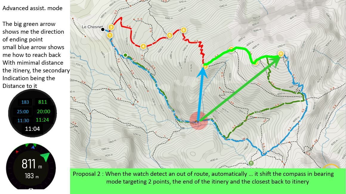
PS : My story dated long long time ago with my father when even GPS was of no use by us, believe me 100 meters in mountain is nothing when you are in fog … you can walk kilometers outside a 100 m range without realizing it, so the probablitiy that you come back in a 100 m range is almost nearby zero
-
@mister-pyc
Out of curiosity … being in the fog with no idea of where to go, as you said, would you follow the “blue arrow” or the “green” one ?Having a map, would you reconsider your choice ?
SVTS - 2.50.28
SSSWHR BARO Amber - 2.8.32
Samsung A5 2016 - Android 7.0
Samsung A33 2022 - Android 16 - One UI 8.0
Suunto App Android 6.10.7 beta
Suunto App IOs 3.8.1 (21743) beta on MBP M1 Max -
@mister-pyc what about reversing the route? Say, you are lost and want to go back off route. How should watch tell whether you need info for start or for finishing?
I think it’s a good idea in a nutshell, but I would prefer watch asking me to switch to bearing navigation towards the end point/start point/poi if it detects prolonged off route activity or on demand
-
@дима-мельниченко said in Is it a navigation BUG .. Distance/ETE/ETA remained empty despite I was not far from the itinery:
I think it’s a good idea in a nutshell, but I would prefer watch asking me to switch to bearing navigation towards the end point/start point/poi if it detects prolonged off route activity or on demand
You can manually do that already, switch to POI, bearing, breadcrumbs, another route, or disable navigation altogether if wanted.
Watch: Suunto Vertical 2 Titanium Black
Blog: isazi's home
-
@isazi also to a start/endpoint of a previously selected route?
-
@дима-мельниченко those are not POIs, but waypoints. If you have phone connectivity, you can create POIs, or even create a new route. If not, better you are prepared in advance.
Watch: Suunto Vertical 2 Titanium Black
Blog: isazi's home
-
@isazi I’m aware. Just saying it would be nice to have as an option.
-
it’s a super good question !!!
Neither the blue nor the green.
And this is exactly why I think this make interresting to have these informations => I will have first of all walked the way I was thinking to go BUT will have observed carefully how the 2 arrows and the distance indications will have spoken to me, permanently reevaluating my navigation options … for exemple … if I see the blue and the green arrow comes to the same angle even if I move, most surely I can go now straight and follow them … if you look to my exemple … this is exactly what will have happen at the end

The fog problem is not a big deal if I’m in a desert, because here I may decide to go straight (assuming there is no quicksand
") … anyway if there was the watch will not have told me in any case).
… anyway if there was the watch will not have told me in any case).The fog problem is interresting to study in mountain because there are constraints (cliff, glaciers, holes, …) but that could also be an advantage, you may arrive to a point which could give you some precious indication (a old farm) and which is on your paper map.
Honestly speaking if I plan a route with such potential risks, I will for sure have also positionned multiple POI, so I will have some multpile backups plan …
I’m more thinking here as a markjeting guy … how could I have promoted the watch instead just to say “Ooopss sorry you are lost” … imagine you can say your watch act as an angel for you
but not … this previous and expensive piece of modernity is now just a useless modern art which fall down in the first trap you put it in.Joking of course … humm … half of joke
Hello! It looks like you're interested in this conversation, but you don't have an account yet.
Getting fed up of having to scroll through the same posts each visit? When you register for an account, you'll always come back to exactly where you were before, and choose to be notified of new replies (either via email, or push notification). You'll also be able to save bookmarks and upvote posts to show your appreciation to other community members.
With your input, this post could be even better 💗
Register Login