Suunto 9 baro very low elevation gain vs other brands
-
@Dimitrios-Kanellopoulos does this algorithm account for horizontal velocity? I have the same sense as @sky-runner - I’m more likely to see differences when cycling then when running. Thanks!
-
@fazel yes. It does.
-
@Dimitrios-Kanellopoulos Thank you!
-
@cosmecosta said in Suunto 9 baro very low elevation gain vs other brands:
Suunto is not adding altitude in increments of 3 m. I do not know the algorithm but not all ascents are multiple of 3 m, as an example: today ascent 73 m (not multiple of 3),
I spent a lot of time watching altitude and ascent fields together while running up and down. I actually have both altitude and ascent fields in feet which gives more precision. 3 meters or 10 feet is the threshold. The watch can increase the ascent by more than the threshold, but I’ve never ever seen it increasing ascent by less than that. Most commonly it adds 10-13 feet at a time, but sometimes more. Yes, the actual resolution is actually less than 1 meter. For example it may add 11 feet which is 3.35 meters. Furthermore once it has increased the ascent value, that seems to be a new baseline because it doesn’t change the ascent value again unless I go at least another 10 feet up.
To give you an extreme example of how total ascent is counted, once I did tiny hill repeats because I ran in a very flat area and that was the best I could find. I did 30 repeats of 17 feet (5.2 m) each. That is about 500 ft total ascent. On the elevation graph in Movescount I could clearly see all 30 climbs and each was 17 (plus/minus 1) feet, which is clearly above the 10 feet threshold. Yet the watch had counted only about 300 ft of total ascent.
As I said, that is an extreme example, but it does demonstrate the issue.
-
This issue is the only one which annoying and disturbing me in this watch

-
@sky-runner that is what I am talking about exactly. If you climb a hill and don’t spend let’s say about 1-3 seconds (stable altitude) on the top then the last 1-3meters might not be counted. Note: Vertical speed plays a role here for this to be triggered / used.
We have several data “tests” over races and workouts to validate this ain’t a big issue.
However this is there for a specific reason, to avoid wind gusts (sudden ascents that don’t last more than 1-3seconds) , rain drops, and your arm / clothing suddenly blocking the pressure holes thus registering ascent and descent.
We don’t do stuff just because we think they should work better. We do deep analysis on data to find the middle group to both create accuracy and avoid problems that the user is facing.
Additionally those parameters are tweaked for each sport mode.
I would like not to expose more internal technology if that is ok with you. Many things have changed there since start of 2020.
The user (OP) probably doesn’t have have this specific issue I think
P.S. There is still one improvement not done and that is latch logic you had described. The reason for that is that as stated above, we cannot change something , without first having a strong RD plan / resource investment
-
@Oktan Did you do some analysis on your claim ?
Would you like me Todo it ? Links and examples please
-
@Dimitrios-Kanellopoulos I registered to Runalyze and loaded the activity there. I’m a simple user and dont undestand what to do next or how to anylize or understand the numbers there, sorry.
I attached the activity a few messages above (https://www.strava.com/activities/4486972002), so if you can test it, it would be great. If you need the gpx from Strava, I can maybe attach it here also.BTW, I looked today at other ride, 73 km long, which I did at 2019 with Ambit 3 Peak, and the same ride this year, 2020, with S9B.
Ambit logged elevation gain of 1491 m (https://www.strava.com/activities/2101913528)
S9B logged elevation gain of 1284 m (https://www.strava.com/activities/3138457224) -
@Oktan can you pm me the suunto app links or fit files so I can analyse this?
I would prefer 1 activity to start with with a format like this:
FIT File or suunto app link
- Expected ascent (ie what other services say)
- Registered ascent
-
@Oktan said in Suunto 9 baro very low elevation gain vs other brands:
BTW, I looked today at other ride, 73 km long, which I did at 2019 with Ambit 3 Peak, and the same ride this year, 2020, with S9B.
Ambit logged elevation gain of 1491 m (https://www.strava.com/activities/2101913528)
S9B logged elevation gain of 1284 m (https://www.strava.com/activities/3138457224)No offense here but all the ascent values that are in Strava when they are pushed from Movescount are not reliable because is not what the watch registered, this ascent is corrected by Strava. Strava only shows the watch ascent if it is pushed from SA. I understand that the activity with the A3 was uploaded using Movescount, have you checked the ascent value in Movescount for that activity?
-
@cosmecosta correct. Movescount doesn’t push the ascent to Strava so Strava recalculates that
-
@cosmecosta you can upload the gpx file manually to Strava. If there is the additional information “with Barometer” in the creator tag of the gpx file, Strava trusts the watch and shows the ascent of the watch and you can use the ascent from the A3 or change it to the ascent of Strava. If not, add it with an editor before uploading the file. A good way to compare watch and Strava data.
-
@sky-runner @Dimitrios-Kanellopoulos
I see that we have a calculation that is not summing up for extreme conditions and hence might under calculate the total ascent. On the other hand I’m glad the watch does not count gusts or when I bent down to fiddle around with the buckles or the climbing bails…so it follows as usual the common rule of development: it is a compromise and all the developers can do is find the best compromise for the majority of athletes

If we’d let people tweak settings like that they would be disappointed due to propably wrong settings, too.
I remember that QS has a function to filter a bit towards more or less sensitivity on that, please correct me if I’m wrong!
I did not touch this setting as I think that Dimitrios as set it to a reasonable setup. -
@Dimitrios-Kanellopoulos said in Suunto 9 baro very low elevation gain vs other brands:
However this is there for a specific reason, to avoid wind gusts (sudden ascents that don’t last more than 1-3seconds) , rain drops, and your arm / clothing suddenly blocking the pressure holes thus registering ascent and descent.
Wind does affect altitude a lot. Below a screenshot with a part of a windsurfing session. According to the data it would have been a bumpy ride

(To be honest, I have no idea why altitude is recorded for an activity type like windsurfing)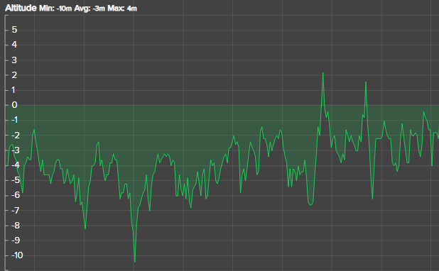
-
@pilleus Thanks for the trick, but what I want to state is that sometimes people put a lot of trust in Strava when the values are wrong. Without any trick an uploaded activity from Movescount, the ascent in Strava doesn’t match the watch, so you can’t compare directly two activities in Strava, if one is pushed from MC and another from SA. Here @Oktan should compare the values from MC and the values from SA to seek discrepancies.
I mean, I use Strava for the social part but I do not trust much the values, at least you have to be aware of the downsizes/tricks. As an example, today I did a trail run with very steep parts, that I had to walk, so Strava decided that I was under their threshold and has decided to improve my pace from the real one 5:26 min/km to 5:19 min/km, I know the trick that only doing a one second pause in the watch, then Strava shows the real pace. So, sometimes, when you see some values in strava they do not need to be correct.
For me the only right values are the ones coming from the watch directly, knowing that an algorithm is an algorithm and can be tuned in different ways.
-
@cosmecosta said in Suunto 9 baro very low elevation gain vs other brands:
sometimes people put a lot of trust in Strava when the values are wrong.
With my old Spartan Ultra I experienced for cycling activities no noteworthy differences between ascent of the watch and ascent of Strava’s GPS based ascent.
I usually have 850 to 1000 meters of climbing on a distance of 35 km with the mountain bike. The difference is usually about 10 to 15 meters between SSU and Strava, if I use the option to use the ascent of Strava.
-
@pilleus Well mi experience is different, in trail running differences can be very big, more than one hundred meters in a 400 m ascent run.
For the MTB, I’m using a dedicated barometric GPS that has always overrode the Strava correction, and Strava shows the GPS value but I have checked using Strava’s correction and:
GPS: 803 m / Strava 766 m
GPS: 697 m / Strava 635 m
GPS: 711 m / Strava 630 mAnd this are 3 random activities that I checked.
So…
-
@cosmecosta I think the problem is the terrain. A GPS track 3 meters away from the path or street in steep and hilly terrain will cause a miscalculation of Strava’s GPS based data.
And I experienced that my SSU is more accurate recording the ascent than my S9B.
-
@Dimitrios-Kanellopoulos said in Suunto 9 baro very low elevation gain vs other brands:
Expected
I dont know how to send you a private message so I loded it here:
-
This is the FIT file from Suunto App (with elevation gain 1243 m):
MountainBiking_2020-12-18T06_44_10.fit -
The elevation gain in Strava is: 1542 m.
-
-
So this is what I do.
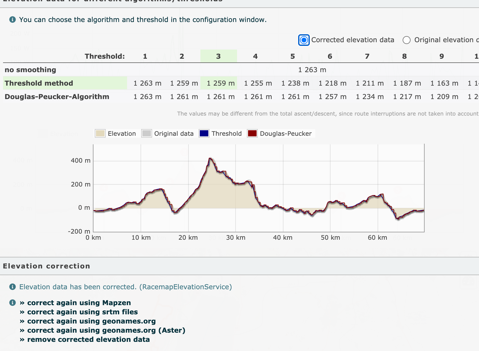
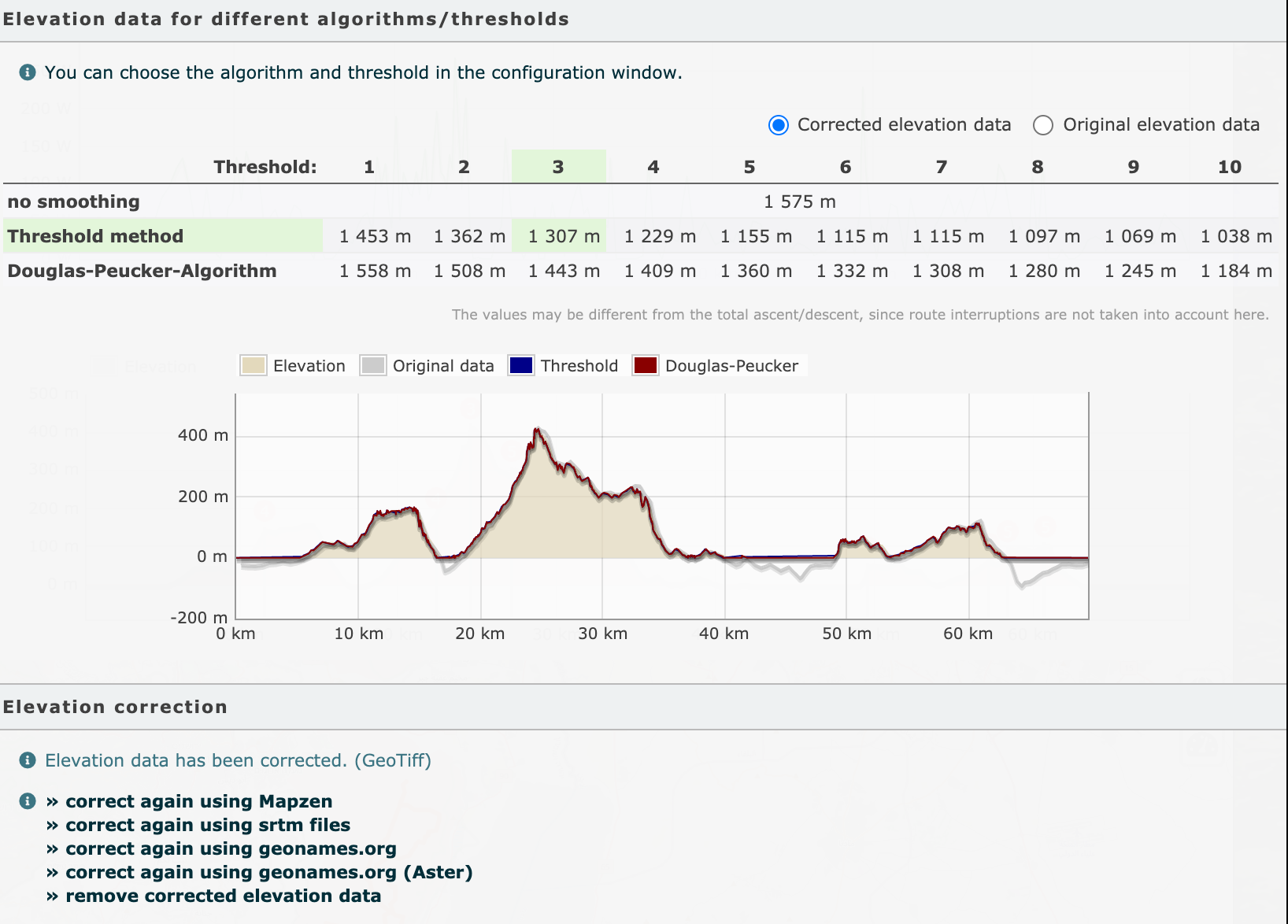
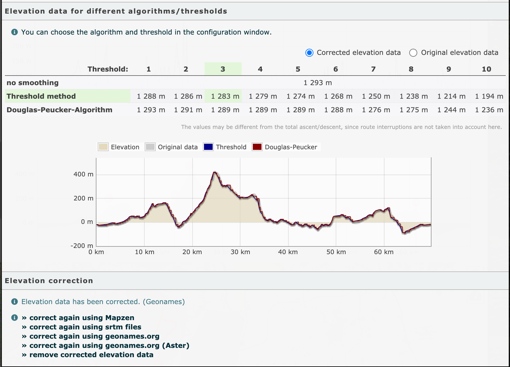
I go to https://runalyze.com/activity/new-upload and upload the fit file.
Then I go to course and elevation data and I correct them with the various DEDB (elevation databases) that the great Runalyze offers
Look at the thresholds! Even Runanalyze defaults to 3m but take a good look and see what is produced with other thresholds as well
- Racemap elevation service
- Geotiff
- Geonames
- Geonames ASter
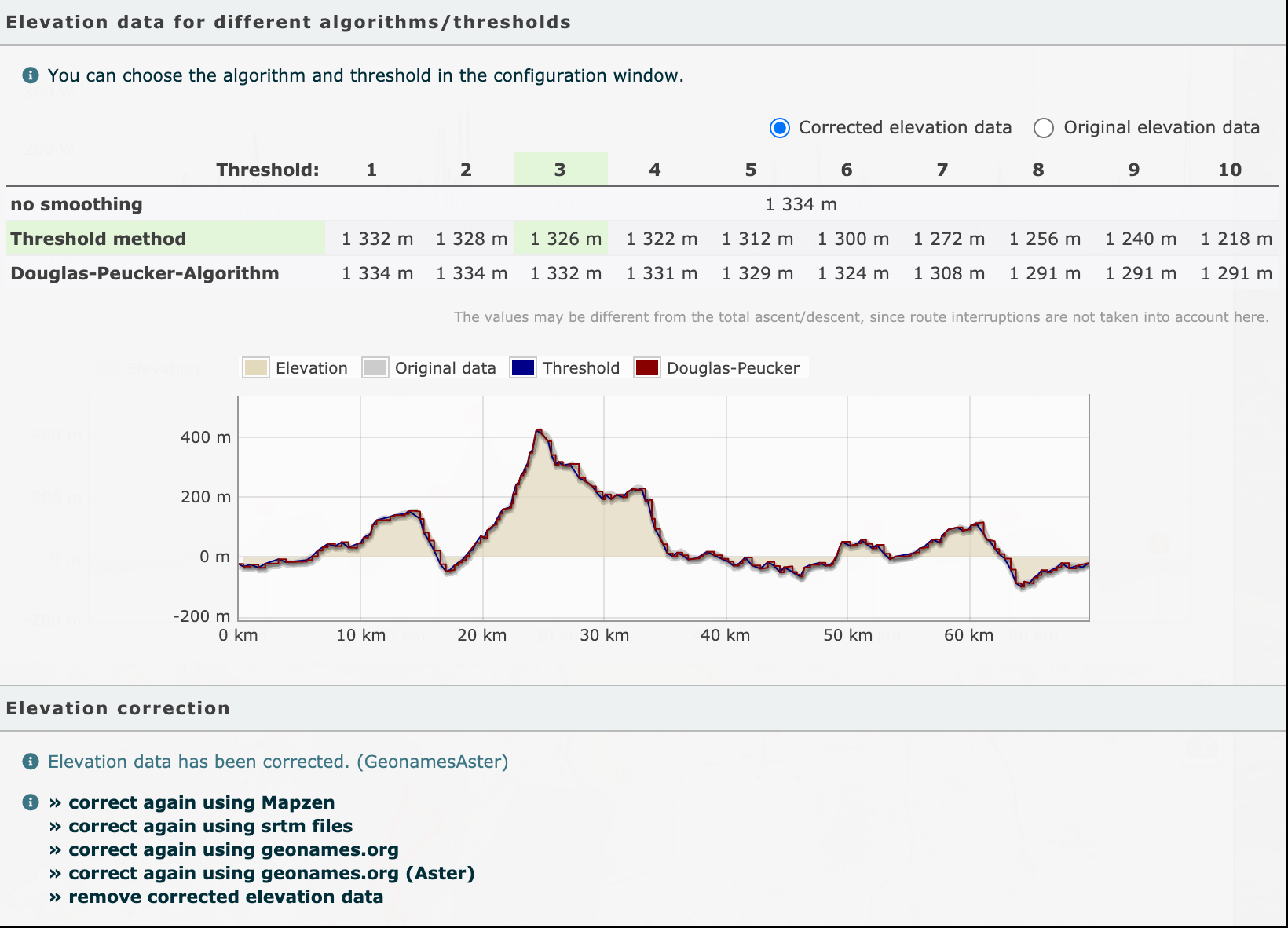
To be honest all show less actually than Strava.
Now since you are using comparing whahoo I had seen this video at the past https://www.youtube.com/watch?v=bPyEtZH3QaU about how much positioning could affect a garmin computer. But I suppose the same flaws can happen with the S9.
My conclusion is that it’s up to you to judge how much ascent you did and with what threshold.
As a reference example here is an analysis of my 16km almost flat bikeride at Netherlands. It is completely almost flat here so:
- No correction (still 13m)
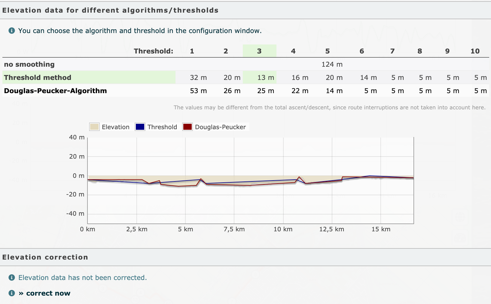
- Racemap
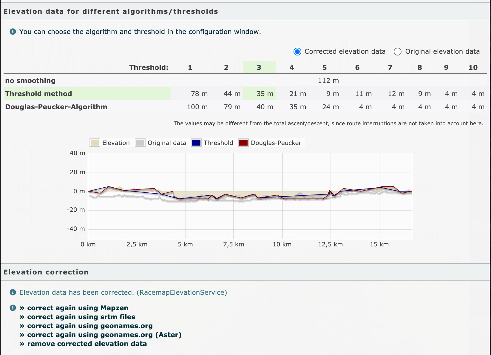
- Geotiff
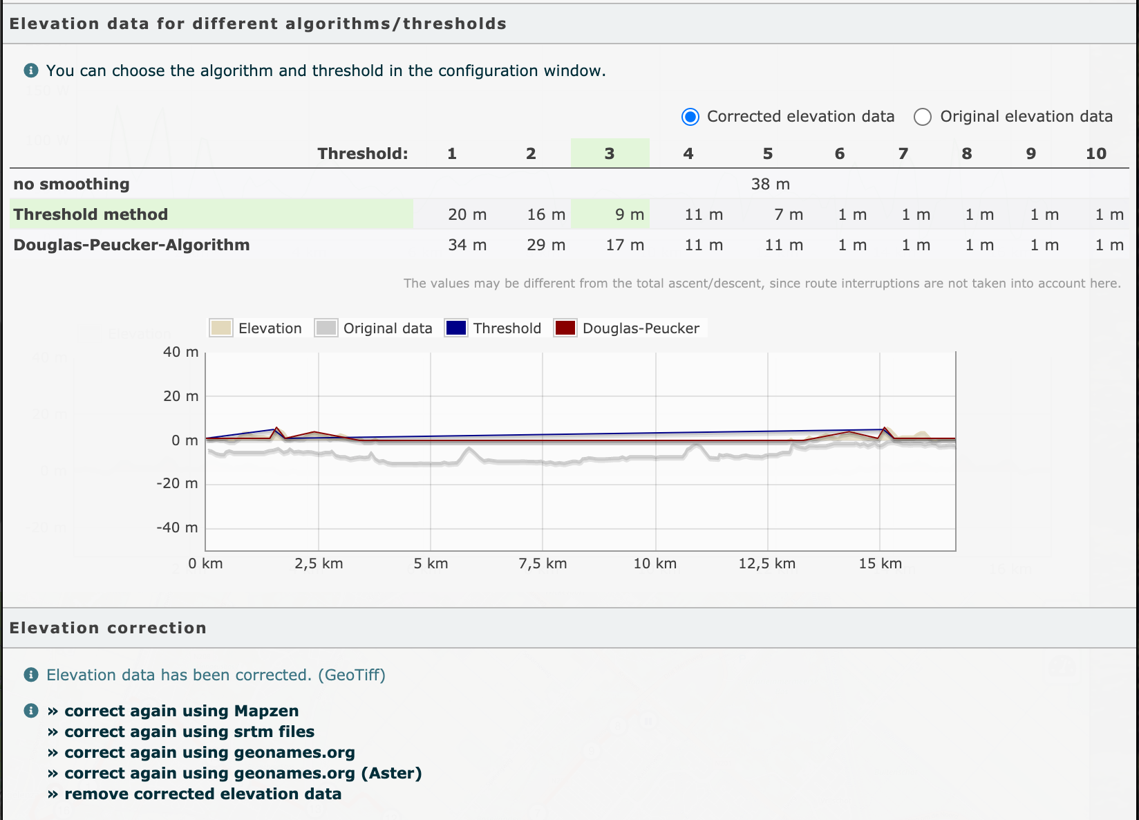
- Geonames
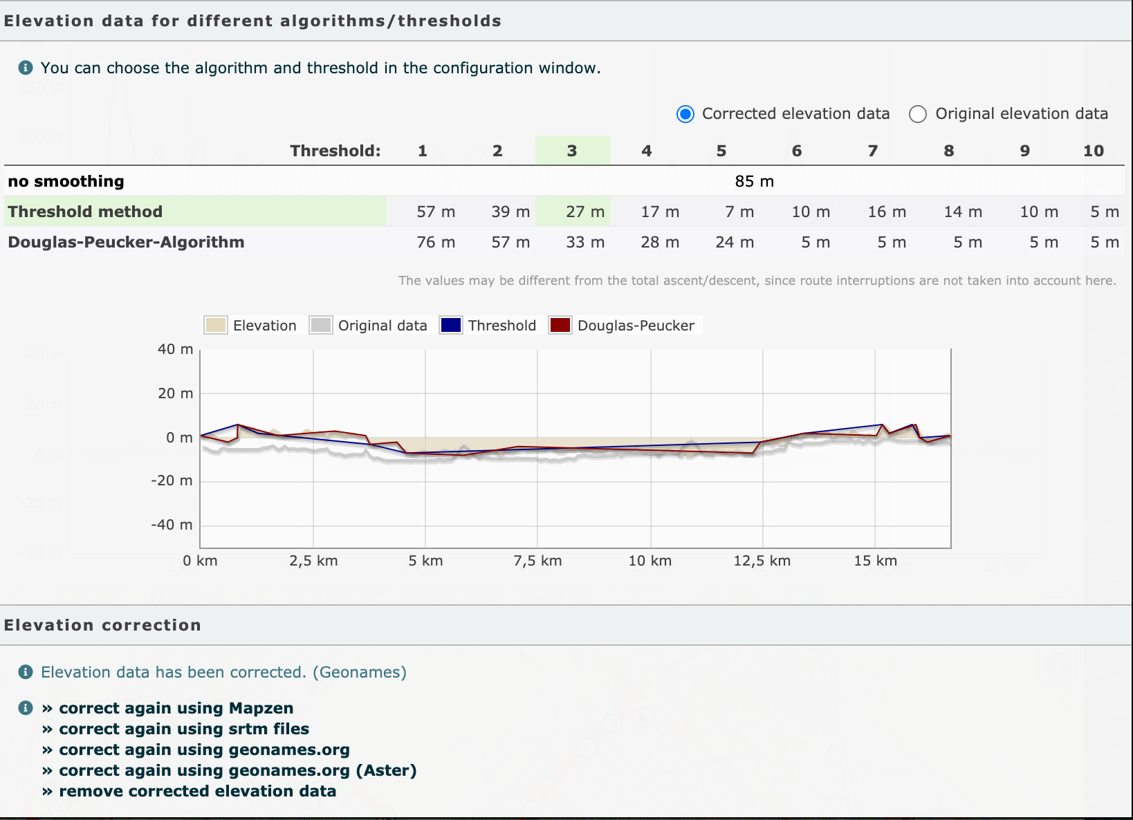
- Geonames aster -> Completly wrong
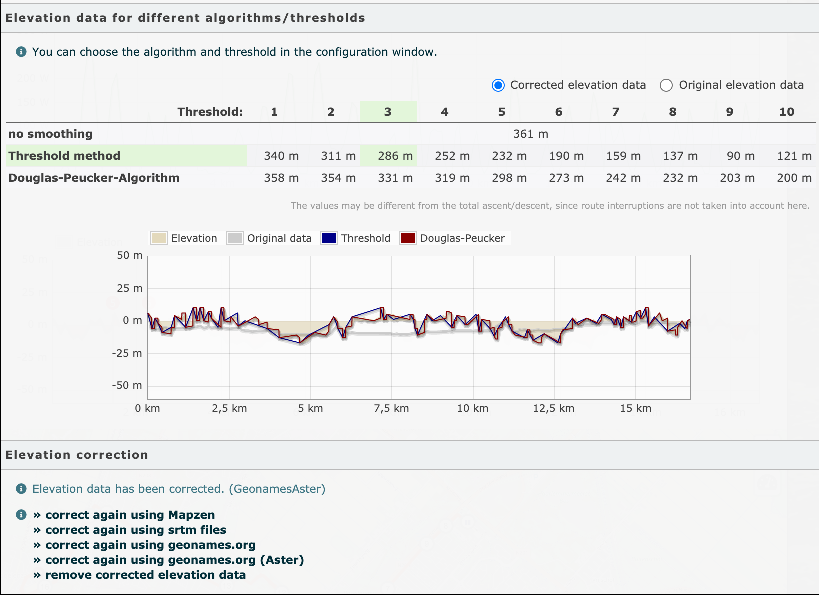
Now, this is my personal opinion.
If you get bothered and you want those extra meters to show at your Strava / Other service or your friends get more ascent etc my advice as I would give to a friend is to get the same device that their friends use or the one that gives you what you want to see for your data.
Why this advice ? Because it all about perspective and no perspective can fit everyone.
I hope this helps
PS: The highlight on the screenshots shows what Runalyze prefers it’s not me highlighting that .
- Racemap elevation service