Suunto app Forum Suunto Community Forum
    • Recent
    • Tags
    • Popular
    • Users
    • Groups
    • Register
    • Login

    Creating Route's

    Scheduled Pinned Locked Moved Suunto app - Questions & Feedback
    4 Posts 3 Posters 219 Views
    Loading More Posts
    • Oldest to Newest
    • Newest to Oldest
    • Most Votes
    Reply
    • Reply as topic
    Log in to reply
    This topic has been deleted. Only users with topic management privileges can see it.
    • omunozO Offline
      omunoz Silver Members
      last edited by omunoz

      Hi Team,

      Every day the app goes better, I really want to say “We have the best App” !!! 🙌🙌🙌🙌

      I explain my situation :

      I created the same route with (Sport Tracker , Suunto App 0.4.0 59998 ,Movescount and Strava) and detect the following :

      • Strava and movescount are very similar in kilometers and altidud. 👍

      • When I created the route with Sport Tracker the info of elevation are 0 and increase the number of kilometers. ( And you can view the same info in the Suunto App )

      • When create the route with Suunto app theinfo of elevation and kilometers increase a lot .

      I attach examples.

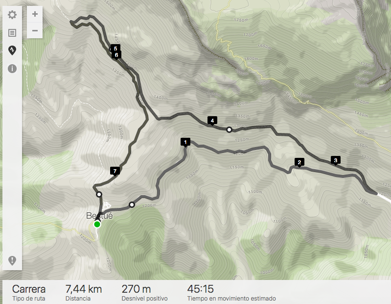
      Movescount image
      0_1520891557977_Captura de pantalla 2018-03-12 a las 22.49.16.png

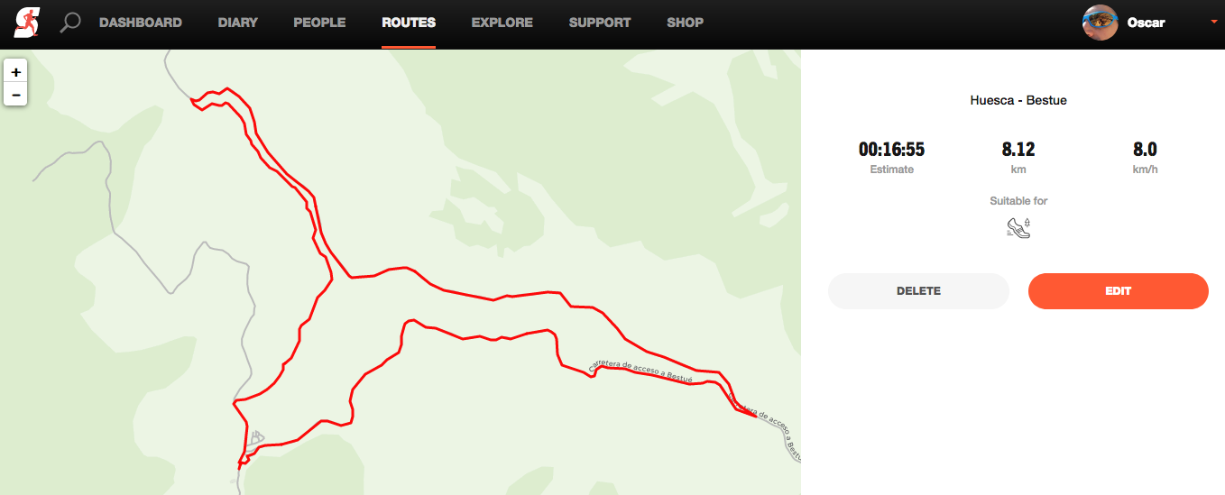
      Strava image

      0_1520891584605_Captura de pantalla 2018-03-12 a las 22.50.15.png

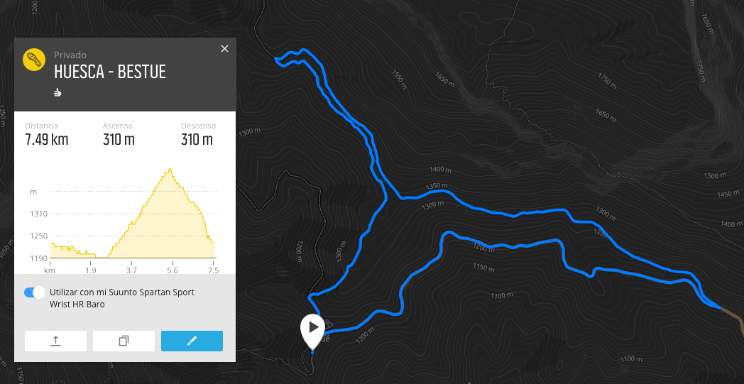
      Sport Tracker

      0_1520891603709_Captura de pantalla 2018-03-12 a las 22.51.16.png

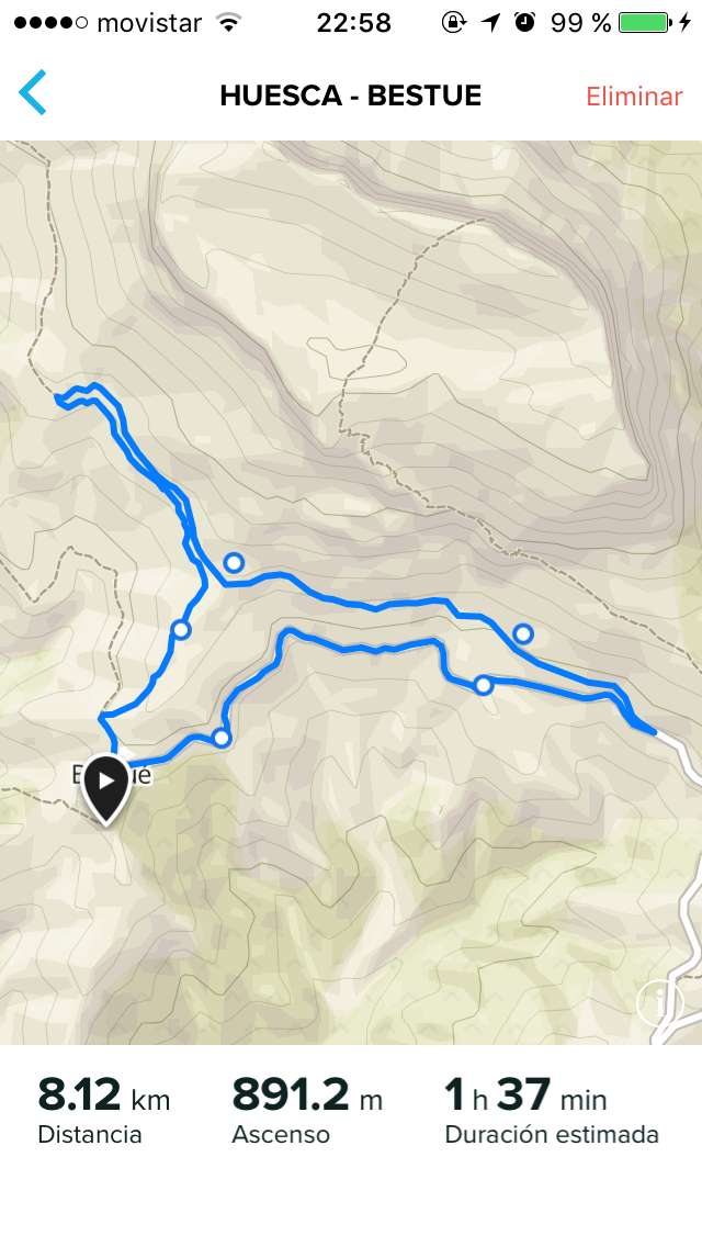
      Suunto App

      0_1520892051363_image1.PNG

      Is problem with integration with Sport Tracker ?

      Watch: SV Fw: 2.40.38

      IPhone 13 (Sim) IOS 18.4.1
      Android 15.0 with Android Studio
      macOS Sequoia 15.4.1 M1 & M2
      Apps IOS: 2.45.0 (19123)
      Apps Android: 4.107.2 (40107002)

      1 Reply Last reply Reply Quote 1
      • Dimitrios KanellopoulosD Offline
        Dimitrios Kanellopoulos Community Manager
        last edited by

        this is a good question. I suppose all of them use a different database for elevation.

        Community Manager / Admin @Suunto
        Creator of Quantified-Self.io
        youtube.com/c/dimitrioskanellopoulos
        https://instagram.com/dimitrioskanellopoulos
        https://www.strava.com/athletes/7586105

        SlaShS 1 Reply Last reply Reply Quote 0
        • SlaShS Offline
          SlaSh Platinum Member @Dimitrios Kanellopoulos
          last edited by

          @dimitrios-kanellopoulos hmm how it can be as all of them should count on topographic maps for elevation which are mostly published by government.

          Dimitrios KanellopoulosD 1 Reply Last reply Reply Quote 0
          • Dimitrios KanellopoulosD Offline
            Dimitrios Kanellopoulos Community Manager @SlaSh
            last edited by

            @slashas said in Creating Route's:

            @dimitrios-kanellopoulos hmm how it can be as all of them should count on topographic maps for elevation which are mostly published by government.

            em sorry that is not correct. Each service, each maps service have their own db

            Community Manager / Admin @Suunto
            Creator of Quantified-Self.io
            youtube.com/c/dimitrioskanellopoulos
            https://instagram.com/dimitrioskanellopoulos
            https://www.strava.com/athletes/7586105

            1 Reply Last reply Reply Quote 0
            • First post
              Last post

            Suunto Terms | Privacy Policy