Several navigation issues (feedback)
-
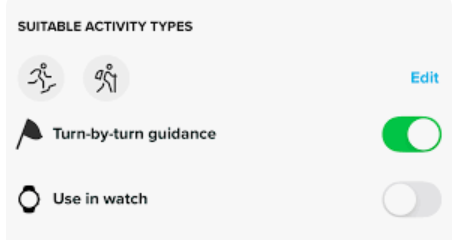
Today I did another test with a different round-trip track.
-
Editing those points of the track in Komoot does not seem to make any effect. The offset is always there.
-
After a while, I went out of the route like 1km and then I returned to the route again and started running back in the route. The autoreverse did not work until a very long time. I started receiving notifications but after skipping many indications.
Another little thing:
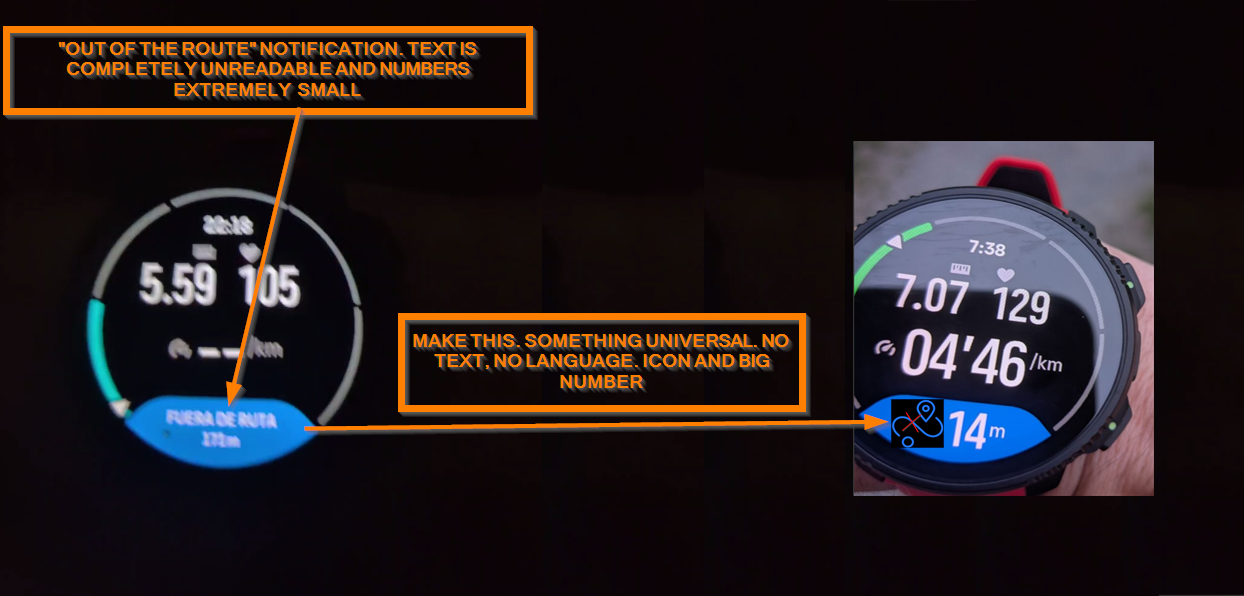
The text when out of the route is extremely small and completely unreadable.
This needs a little fix (that icon is just an invented one as an example, and colors and everything should be according to the layout)
-
-
D dreamer_ referenced this topic on
-
After 10 days, I have the answer provided by Komoot
Hello there,

Thanks for your message.

What you’re seeing is related to how komoot processes imported GPX files, and I’m happy to explain what’s happening and what you can try.

When you import a GPX file as a planned route, komoot doesn’t display the track exactly as it is. Instead, it processes it through its routing system. During this step, you’re usually given two options:

Stick to original route: keeps the track as it is, though some sections may appear as straight (off-grid) lines if they don’t match known paths. Navigation can be less precise in those parts. Match route to known ways: adjusts the route to follow mapped paths, which can slightly change the original track but often improves navigation guidance.

For round trips where the route overlaps itself (for example, going out and back along the same path), this processing can sometimes lead to unexpected results. You might see gaps, shifted endpoints, or the route not finishing exactly where it should. This can also lead to “off route” notifications on your watch.

Regarding turn-by-turn instructions, komoot provides guidance slightly before the actual turn to allow time to react. On connected devices like Suunto watches, this can feel more noticeable due to how the data is transferred, so a small offset is expected. Larger differences are often linked to how the route was interpreted during import.

Here are a few things you can try:
Re-import the GPX file on the komoot website and choose Stick to original route, then review the route carefully before saving
If the route is quite long and you’re using Premium, try importing it as a multi-day Tour with the same option
After saving, open the route in the planner and check that the endpoint and path look correct before syncing it to your device

If the route still doesn’t appear correctly after this, it falls into a known area where GPX imports can behave differently than expected. At the moment, there isn’t a way to fully prevent komoot from processing the file through its routing system.

If you have any other questions or need assistance in the future, don’t hesitate to reach out. We’re here to help!

Have a great day!
komoot Support Team
They basically confirm:
- GAPs and missing parts which can lead to “out of the route” notifications (and wrong Climb Guidance ones).
- Delays with turn-by-turn indications
So those both navigation issues Suunto watches have, are basically caused by Komoot, as I was pretty sure. I’ll continue with the support explaining other things like several turns in quick succession (and considering the delays), but this is a dead end.
-
I can’t try until Sunday but I wanted to share if anybody wants to try, since I have an interesting answer from Komoot’s
Thanks for sending the GPX file.

I took a look and found a workaround that should help you save the full route:
Click New > Import a GPS Route
Drag and drop the GPX file
Instead of selecting Import to Plan a Route, select Import as Activity
Tap Import Activity


This saves the file as a completed Activity on your account. On the map, the route should connect all the way to the end.

After that:
Click the three-dot icon on the right
Select Make a Copy
Click Save


The copied route will be on the Saved Routes. It should then show the full route from the completed Activity, rather than being cut short like it was when imported directly as a planned route.

You may, of course, delete the Completed Activity after.

Let us know how it works for you.

All the best,
komoot Support Team
So this solves the pre/post processing issues (perhaps) for the GAPs, and perhaps the offset thing. I’d like to test it now, but I’m out this weekend, lol.
-
-
said in Several navigation issues (feedback):
I can’t try until Sunday but I wanted to share if anybody wants to try, since I have an interesting answer from Komoot’s
Thanks for sending the GPX file.

I took a look and found a workaround that should help you save the full route:
Click New > Import a GPS Route
Drag and drop the GPX file
Instead of selecting Import to Plan a Route, select Import as Activity
Tap Import Activity


This saves the file as a completed Activity on your account. On the map, the route should connect all the way to the end.

After that:
Click the three-dot icon on the right
Select Make a Copy
Click Save


The copied route will be on the Saved Routes. It should then show the full route from the completed Activity, rather than being cut short like it was when imported directly as a planned route.

You may, of course, delete the Completed Activity after.

Let us know how it works for you.

All the best,
komoot Support Team
So this solves the pre/post processing issues (perhaps) for the GAPs, and perhaps the offset thing. I’d like to test it now, but I’m out this weekend, lol.
I tried this. I noticied an slightly improvement and the track is 20 meters more using this workaround. But the offset and the false “out of the route” issues persist. In fact, I’m getting wrong Climb notifications in this round-trip scenario (things like downhill notifications when you are going up and uphill notifications when you are going down). Autoreverse does also need a serious work.
-
Latest Komoot answer.
Thanks again for taking the time to test the workaround and share such detailed feedback throughout this investigation.

It’s helpful to know that importing the GPX as an Activity first and then copying it to Saved Routes improved the route ending behavior, even though the small offset and the turn-by-turn and climb notification issues are still present on your Suunto Vertical 2.

After reviewing all the information you provided, including the original GPX behavior across different platforms, it’s clear that komoot is interpreting this specific route differently during processing. Your detailed comparisons have been especially valuable in narrowing this down.

At the moment, komoot still needs to process imported GPX tracks through its routing system, so there isn’t yet a setting that completely preserves the original track geometry in all edge cases.

We're constantly developing and working on improving komoot, and rest assured, we're actively listening to the community to incorporate your ideas into our work whenever possible. Since komoot is used for various sports and purposes, we receive a wide range of requests. We collect, categorize, and evaluate all input to understand what will help the most users.

I've shared your insights internally for review. You can stay up to date with the latest features and improvements on our What's New and Product Updates pages.

Please note that we release weekly updates for the komoot app and website. Ensure your app is updated to take advantage of these improvements.

Thanks again for your patience, persistence, and the high level of detail you shared during testing.

Have a lovely day,
That basically means, end of support using the words an user wants to hear. Komoot’s support admits the issues but just that. Nothing further. This seems a dead-end in any case.
-
-
-
said in Several navigation issues (feedback):
Latest Komoot answer.
Thanks again for taking the time to test the workaround and share such detailed feedback throughout this investigation.

It’s helpful to know that importing the GPX as an Activity first and then copying it to Saved Routes improved the route ending behavior, even though the small offset and the turn-by-turn and climb notification issues are still present on your Suunto Vertical 2.

After reviewing all the information you provided, including the original GPX behavior across different platforms, it’s clear that komoot is interpreting this specific route differently during processing. Your detailed comparisons have been especially valuable in narrowing this down.

At the moment, komoot still needs to process imported GPX tracks through its routing system, so there isn’t yet a setting that completely preserves the original track geometry in all edge cases.

We're constantly developing and working on improving komoot, and rest assured, we're actively listening to the community to incorporate your ideas into our work whenever possible. Since komoot is used for various sports and purposes, we receive a wide range of requests. We collect, categorize, and evaluate all input to understand what will help the most users.

I've shared your insights internally for review. You can stay up to date with the latest features and improvements on our What's New and Product Updates pages.

Please note that we release weekly updates for the komoot app and website. Ensure your app is updated to take advantage of these improvements.

Thanks again for your patience, persistence, and the high level of detail you shared during testing.

Have a lovely day,
That basically means, end of support using the words an user wants to hear. Komoot’s support admits the issues but just that. Nothing further. This seems a dead-end in any case.
Today I tried the TBT of that roundtrip route in my wife’s Suunto Run and it’s a good test to see the issue. The thing is that the Run only notifies the TBT with a vibration so you are not looking at the screen for the TBT.
It’s super clear the vibration is inside but mostly after the turns, which is very bad. -
@dreamer_ Run is a different platform compared to the other Suunto watches, even with its own dedicated R&D, so it’s normal to see noticeable differences in certain areas.
The focus of Run is to be Suunto’s entry-level offering, mainly targeted at road runners who occasionally practice other sports.
The goal behind Run is to provide an affordable watch for users who are not 100% outdoor-focused, allowing them to experience the Suunto ecosystem at a more accessible price point. If they enjoy the experience, they can later move up to the more “premium” lineup such as the Suunto Race S, Suunto Vertical 2, Race 2, and so on.
As an outdoor user myself, I completely understand your concerns and I even share some of them. However, I think we also need to carefully differentiate the entry-level Run range from the more advanced models. Let’s see what surprises a future Run 2 may bring.
Regarding the turns, this only happens to you with Komoot, right? With routes created directly in the Suunto app, everything works perfectly?
-
@Joaquin said in Several navigation issues (feedback):
@dreamer_ Run is a different platform compared to the other Suunto watches, even with its own dedicated R&D, so it’s normal to see noticeable differences in certain areas.
The focus of Run is to be Suunto’s entry-level offering, mainly targeted at road runners who occasionally practice other sports.
The goal behind Run is to provide an affordable watch for users who are not 100% outdoor-focused, allowing them to experience the Suunto ecosystem at a more accessible price point. If they enjoy the experience, they can later move up to the more “premium” lineup such as the Suunto Race S, Suunto Vertical 2, Race 2, and so on.
As an outdoor user myself, I completely understand your concerns and I even share some of them. However, I think we also need to carefully differentiate the entry-level Run range from the more advanced models. Let’s see what surprises a future Run 2 may bring.
Regarding the turns, this only happens to you with Komoot, right? With routes created directly in the Suunto app, everything works perfectly?
I tested the Run using the route created with Komoot’s algorythms. That’s the key of my post (no matter if I was using the Run or my Vertical 2 Titanium, since I used Komoot’s algorythms for creating the GPX with TBT indications).
About the issue, you are right. It seems created by Komoot and it happens in both my Vertical 2 and my wife’s Run. It’s very clear Joaquin. In fact, Komoot’s support confirmed the offset is created by them.
There are also several things I was talking , like missing the final part in that route because Komoot’s issue or wrong Climb notifications because Komoot does a pre/post-processing of the routes, affecting the performance of the navigation to several things.But if you want TBT in a route that is already created (I.E, a GPX track provided by a race organization) , at this moment. you need to use Komoot.
In my opinion, now you have a super nice tool like Route Planner, I’d be incredible nice if all the algorythms are made by Suunto instead of using Komoot’s.
-
@Joaquin I’d like to revisit the issue of creating a route in offline mode on iOS. I recently ran into this, and the app generated a route in a straight line without using trails. Is it normal for the route to be generated without using trails? What should I do in this situation—for example, should I create a route using waypoints (which will result in straight lines between the waypoints)?
Update: I accidentally opened the map settings and discovered that you can switch between online and offline modes. The route is calculated based on the selected mode. In offline mode, without a mobile network connection, the route is calculated using trails. -
@dreamer_ I recreated exactly the same route in both platforms after several years without using Komoot, because I manually create all my routes directly in the Suunto ecosystem and realistically no longer need Komoot.
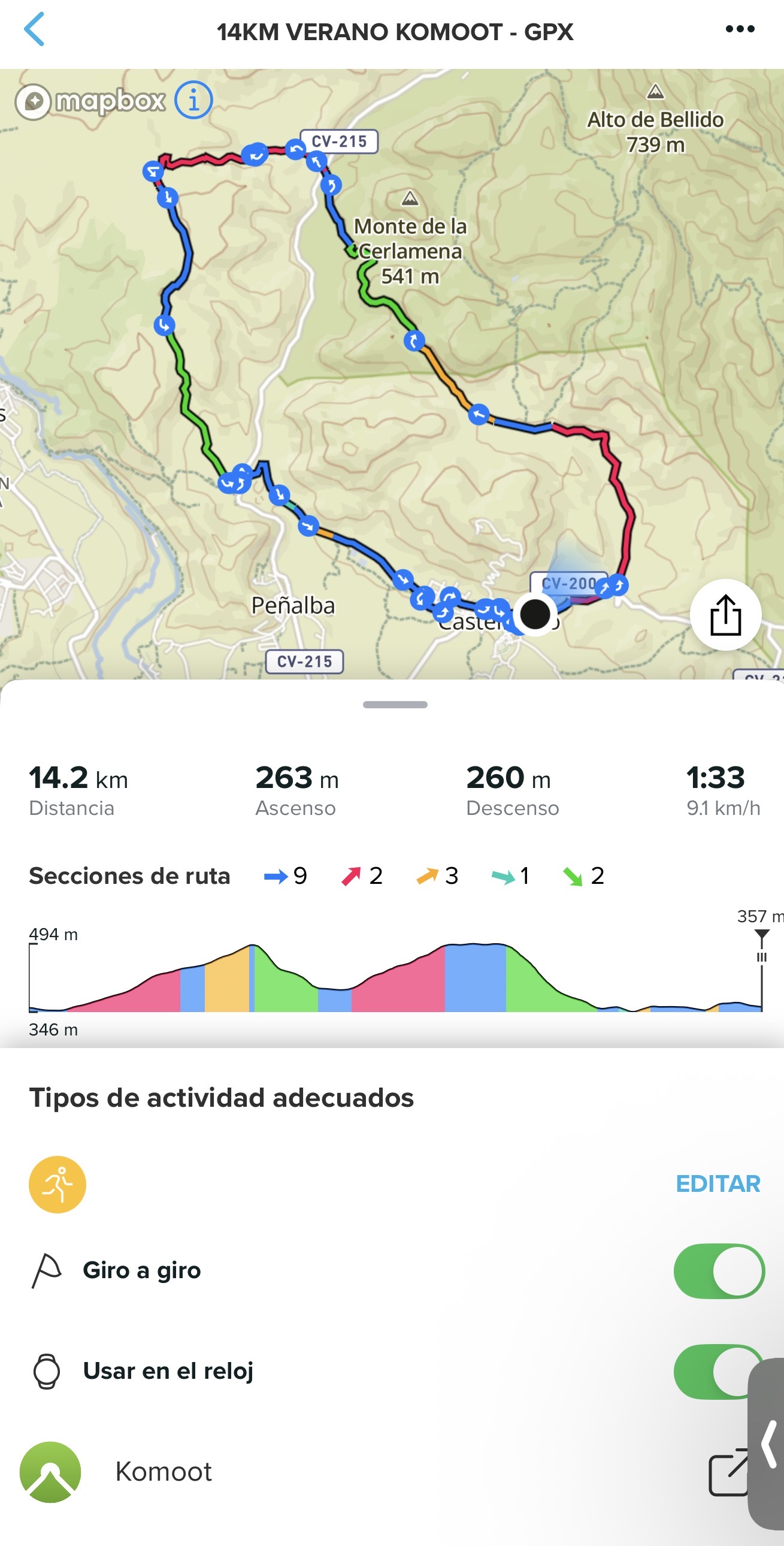 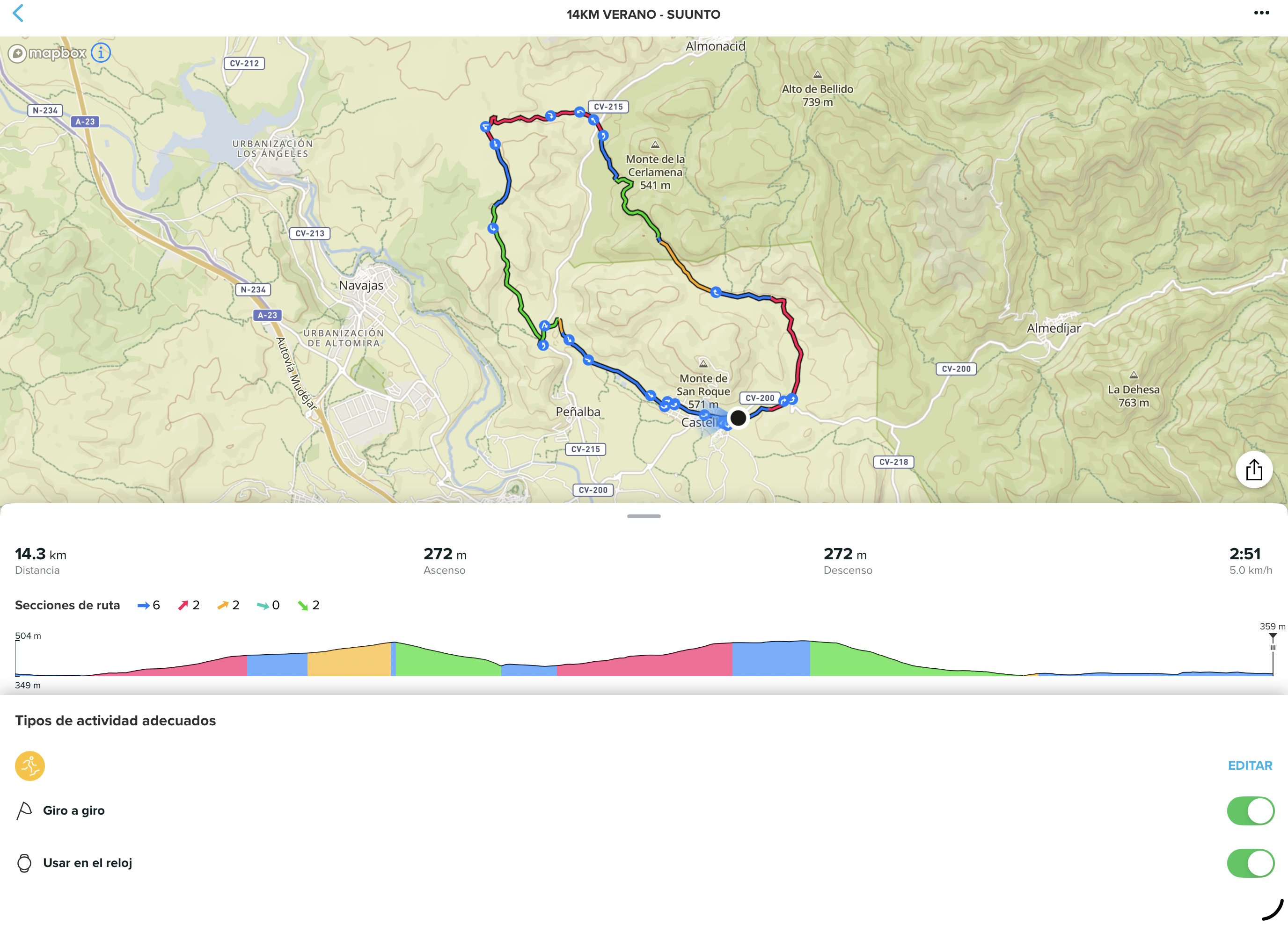
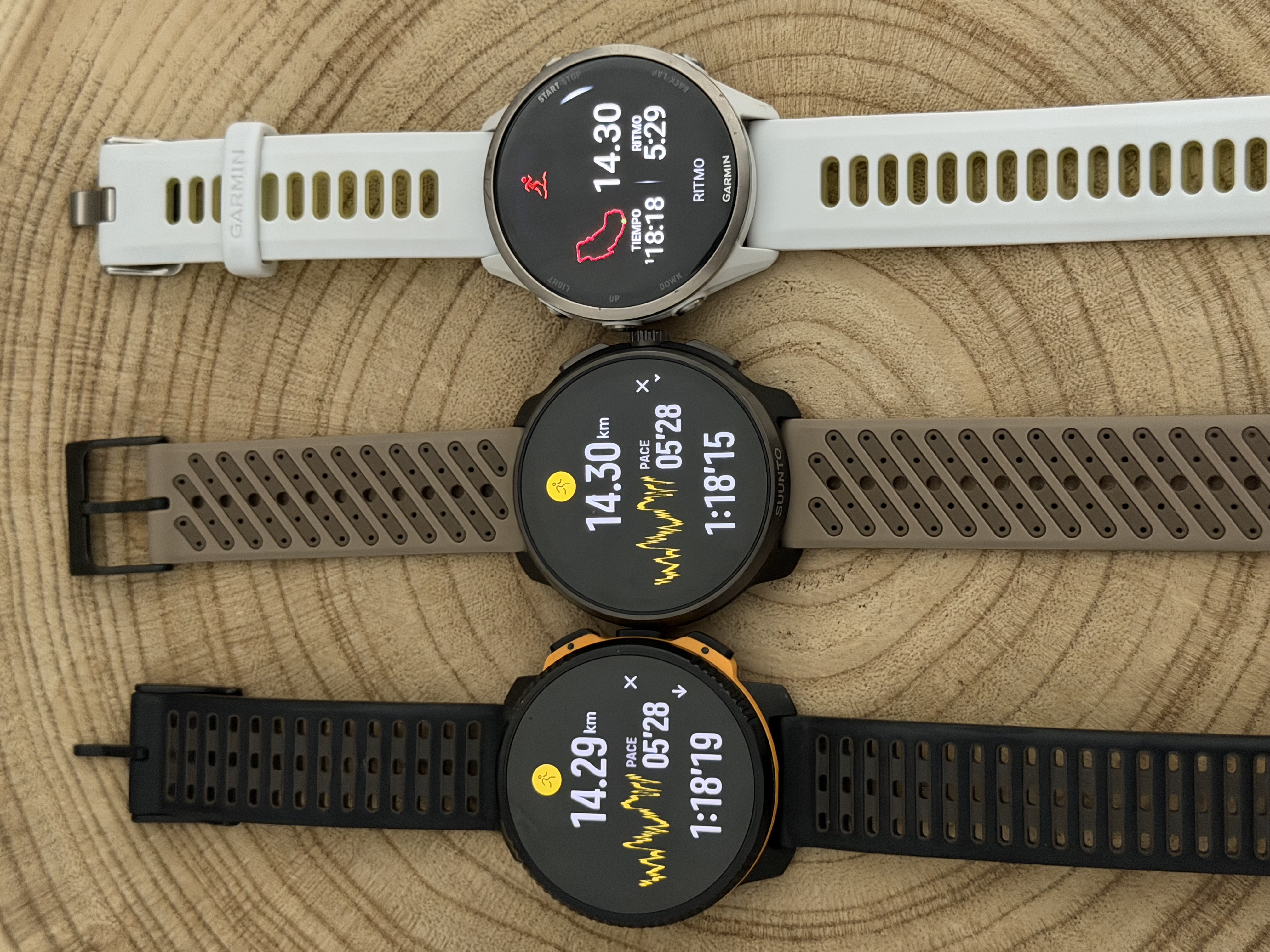
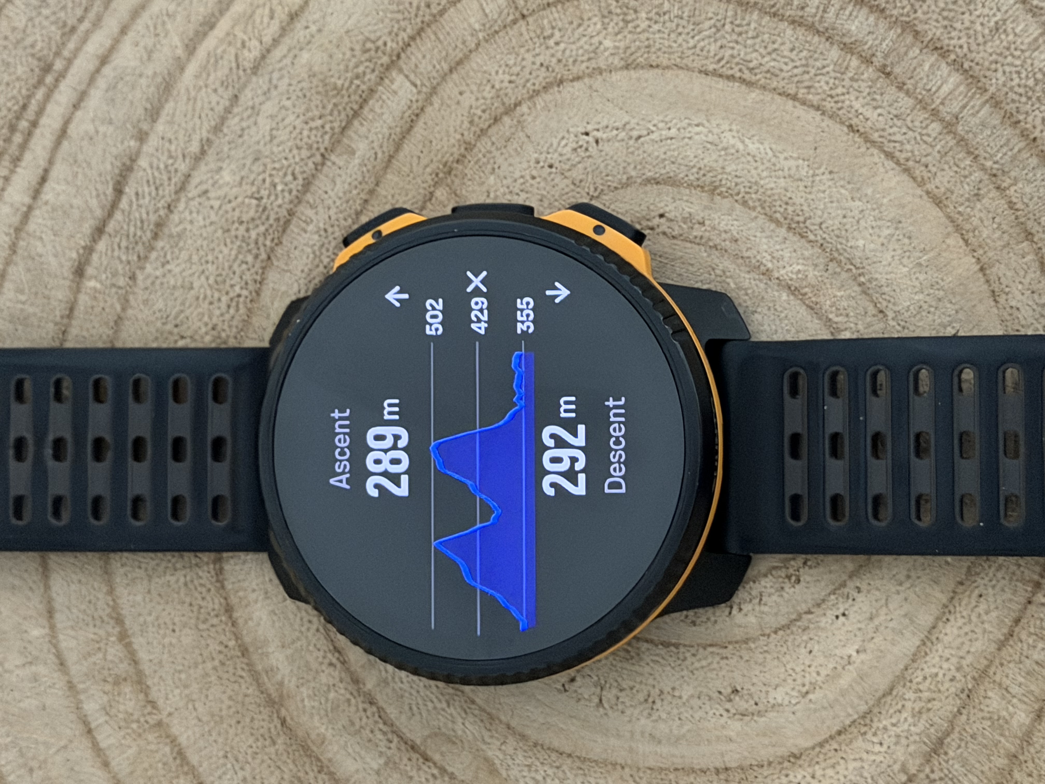
However, after testing both side by side, I found several serious issues that should be addressed, especially considering that Komoot’s core business is route creation and reliable turn-by-turn navigation for sports watches. In this case, Suunto cannot really do anything because the problem originates from Komoot’s route and elevation data itself.RACE 2: SUUNTO APP
VERTUCAL 2 : KOMOOT- Distance and elevation discrepancies
The route generated in Komoot shows a shorter total distance compared to the same route created in Suunto App, which appears significantly more realistic and accurate.
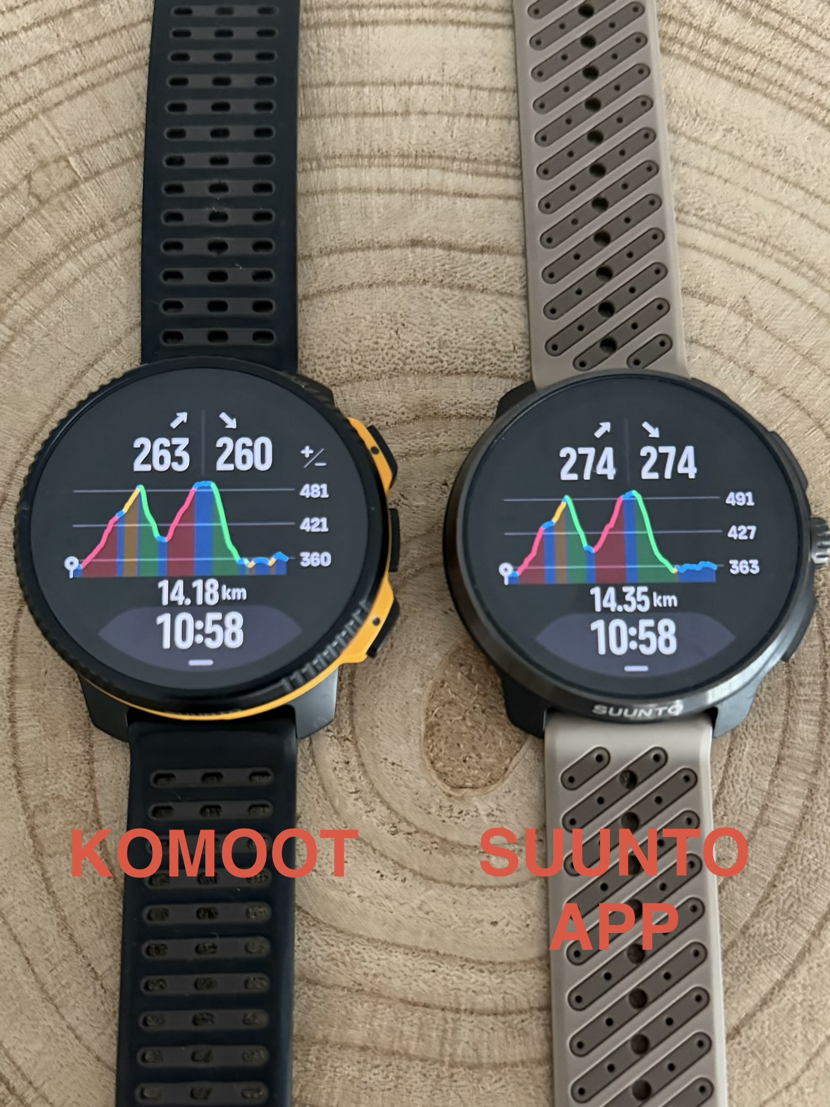
- Komoot: 14.2 km / 263 m ascent
- Suunto App: 14.3 km / 272 m ascent
This difference may seem small on a short route, but in ultra-distance activities these accumulated discrepancies could become a significant issue.
- DEM elevation data quality and Climb Guidance accuracy
The biggest problem is clearly related to the DEM (Digital Elevation Model) data used by Komoot.
The elevation profile generated by Komoot appears to use a much lower-resolution DEM source. This affects:
- Total ascent/descent calculations
- Elevation precision
- Turn-by-turn climb segmentation
- Climb Guidance accuracy on watches
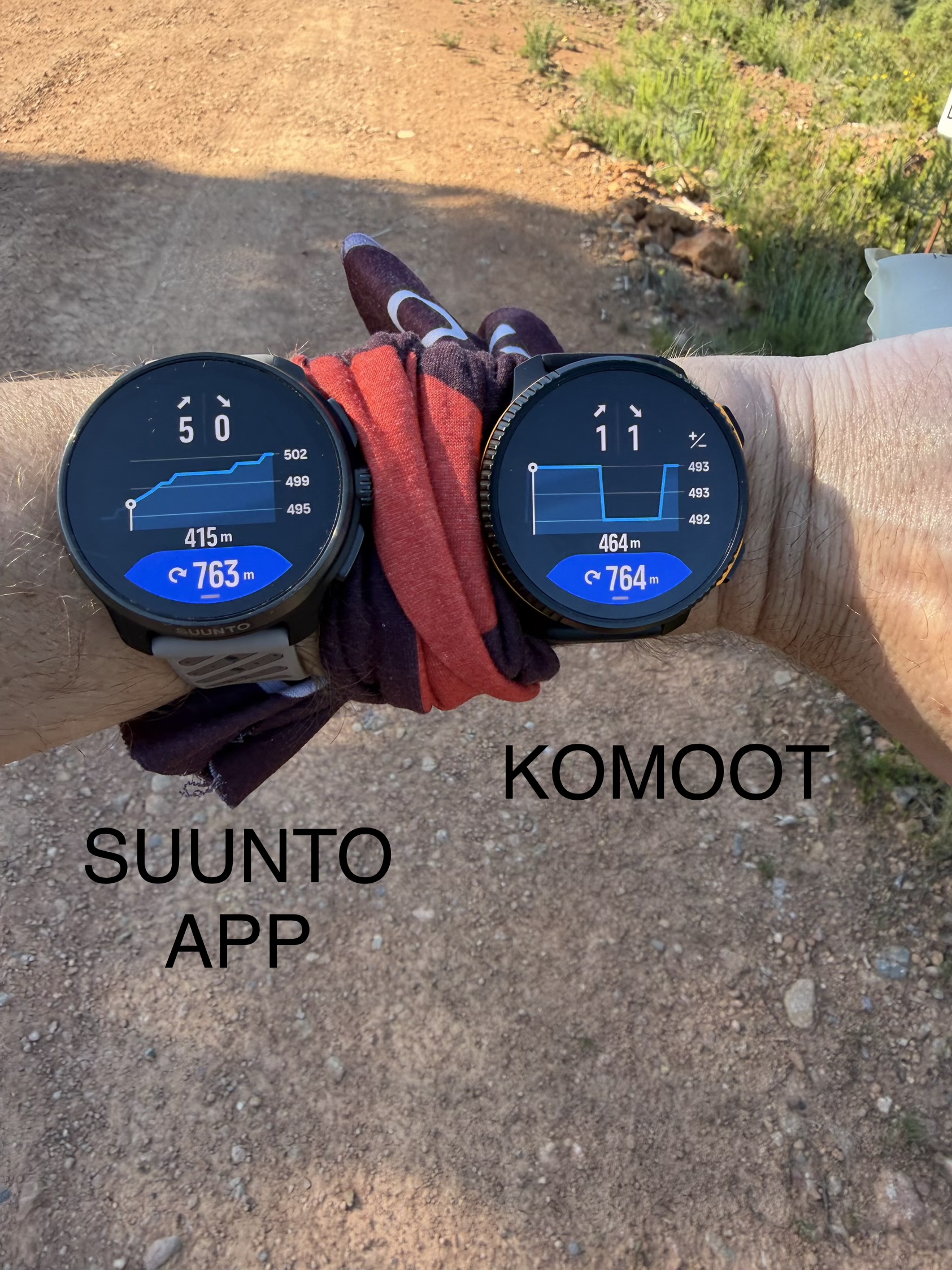
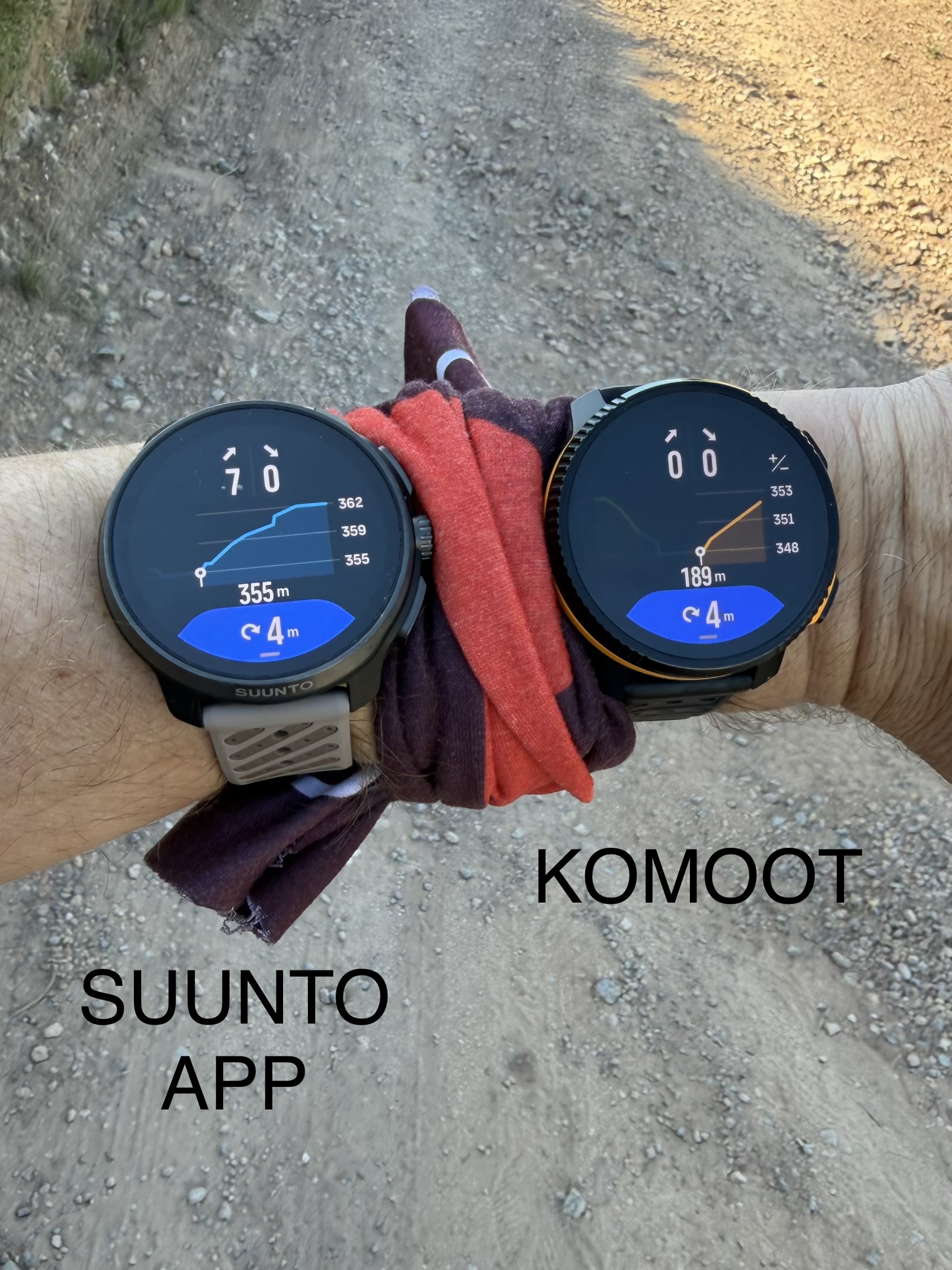
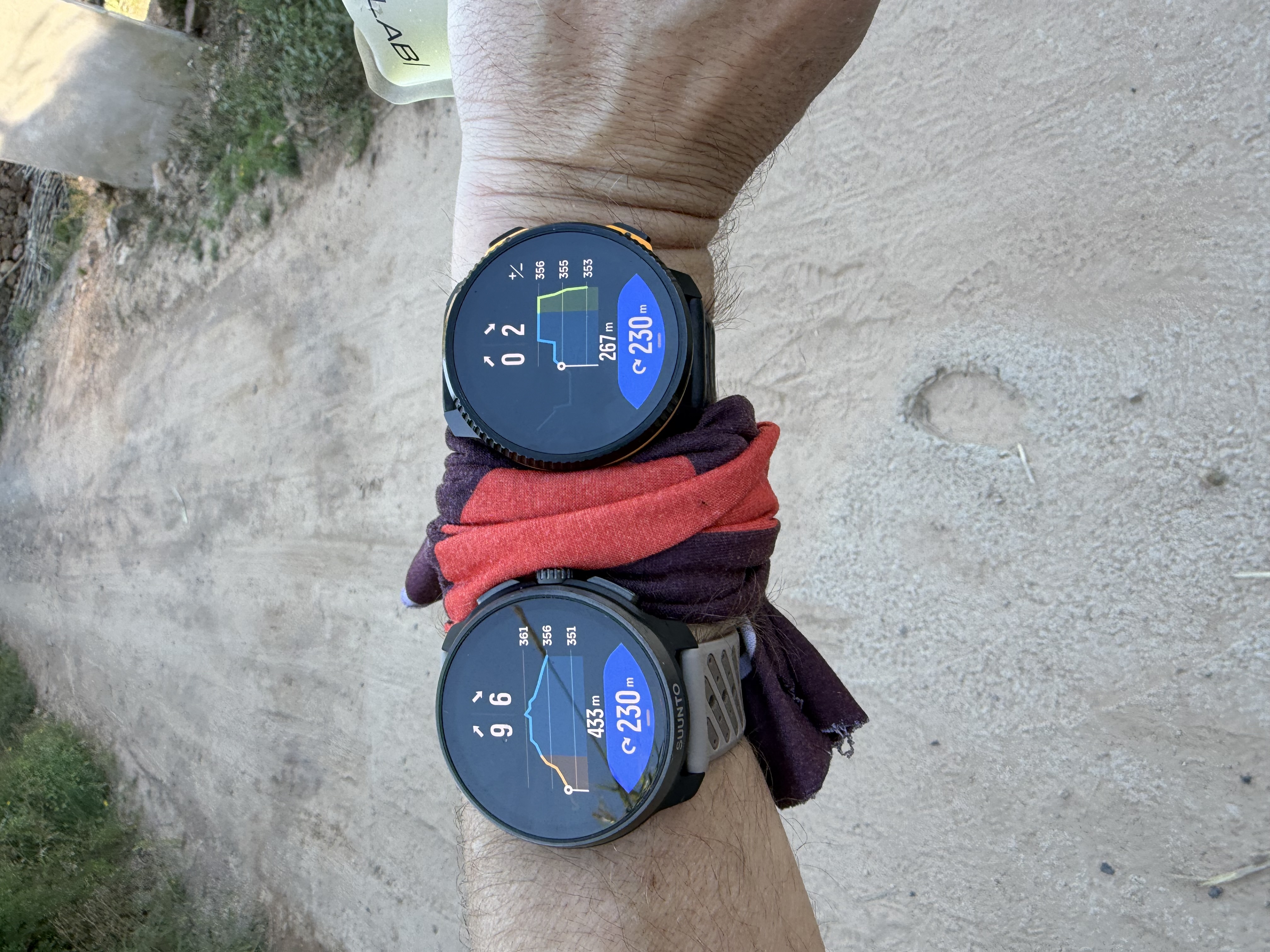
At first glance, the overall elevation profile may look acceptable, but when analyzing the route in smaller sections (around 500 m), it becomes obvious that Komoot simplifies the terrain excessively and often represents elevation changes as straight lines.
Because of this:
- Flat sections are sometimes shown as climbs
- Climbs can appear smoother or shorter than they really are
- Small terrain variations completely disappear
- The resulting climb profile becomes much less detailed and less accurate
This creates the false impression that Suunto Climb Guidance is inaccurate, when in reality the issue comes from the DEM data and elevation processing provided by Komoot.
The attached photos clearly show these inconsistencies:
- Different ascent/descent totals between both platforms
- Simplified elevation graphs in Komoot
- More realistic and detailed terrain representation in Suunto App
- Incorrect micro-profile interpretation during navigation
For a platform whose primary purpose is route planning and navigation for outdoor sports, this level of DEM simplification is a major weakness that directly impacts the user experience on connected watches.
Technical & Product Specialist – Suunto Iberia
-
@dreamer_ continue
- Turn notification inconsistencies
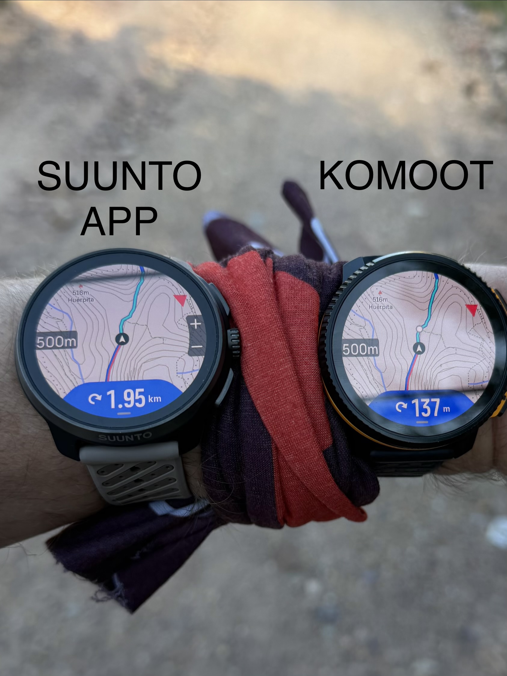
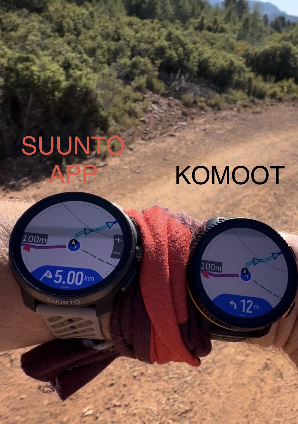
Most turn notifications matched correctly between both routes, but I detected several situations where Komoot-generated navigation prompts arrived noticeably later.
What makes this particularly interesting is that:
- Distance-to-turn was often almost identical
- Turn coordinates were effectively the same
- GPS positioning on the watches was correct
However, the cumulative distance from the route start was consistently shorter in the Komoot route.
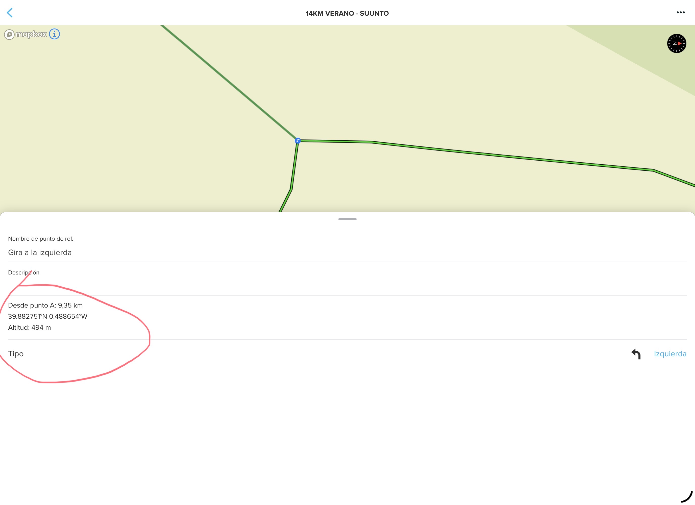
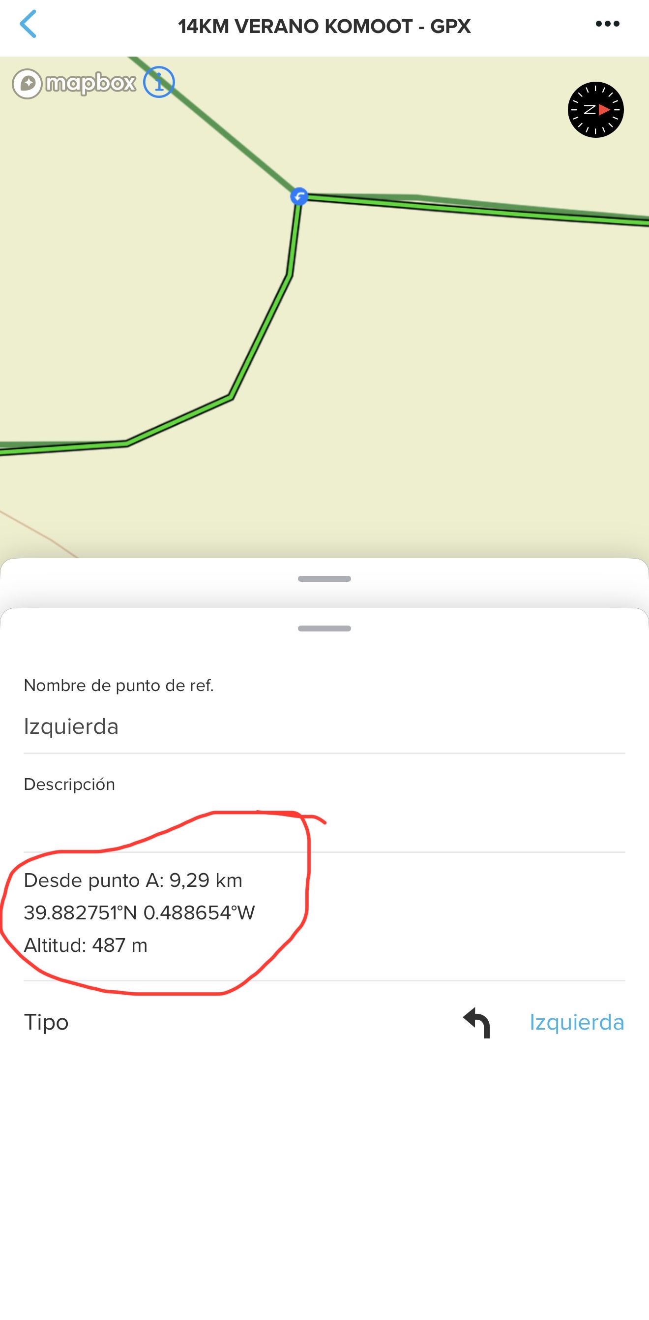
Example from the screenshots:
Same turn coordinates:
- 39.882751ºN 0.488654ºW
But different cumulative route distances:
- Komoot: 9.29 km
- Suunto App: 9.35 km
This strongly suggests there may be inaccuracies in how Komoot calculates cumulative route distance between navigation points.
Additionally, the Komoot route geometry itself appears more simplified, with fewer intermediate track points and straighter path interpolation.
That simplification may explain why some turn notifications feel delayed despite the physical turn location being correct.
Additionally, it also creates some unnecessary turns, since if I go straight ahead on the same route, there’s no need for a “go straight ahead” notification.
Overall, after recreating and testing the exact same route in both ecosystems, the main problems I found in Komoot can be summarized as follows:
- Less accurate total distance calculation
- Lower-quality DEM elevation data
- Simplified elevation profiles with loss of terrain detail
- Inconsistent ascent/descent calculations
- Less precise climb segmentation
- Reduced Climb Guidance accuracy
- Oversimplified route geometry with fewer intermediate points
- Delayed turn-by-turn notifications in some situations
- Inconsistent cumulative distance calculations between navigation points
- Navigation behavior that feels less precise on the watch despite correct GPS positioning
The most important conclusion is that many of the perceived navigation or Climb Guidance inaccuracies on the watch are not actually caused by the watch itself, but rather by the quality of the route, geometry, and elevation data generated by Komoot.
Technical & Product Specialist – Suunto Iberia
-
@Joaquin said in Several navigation issues (feedback):
The route generated in Komoot shows a shorter total distance compared to the same route created in Suunto App
I suppose this applies to Suunto’s online route planner as well, right?
-
@Joaquin I’m really loving your answers. This is really very good work. You took a lot of time and effort for this. Thank you so much for all of this.
About the delay of the TBT notifications, I think it’s even more noticeable in a round-trip scenario but when you repeat the same way-out and way-back. And Climb Guidance is also very affected with bad performance because of Komoot’s, and as you are already pointing very well.
In fact, I had very clear from the very first moment that the issue is caused by Komoot and not Suunto (that’s the reason I opened that case to Komoot). But the thing is we have an issue here, and this is important since we are using Komoot to import tracks provided by others and have TBT indications.As I was also explaining, my routes are also sorter in Komoot. When zooming, I’m finding inaccuracies in Komoot, things that are not happening in Route Planner and others. There’s some kind of pre-post/processing in Komoot that is not good and that is affecting to the offset of the TBT I was talking about, but also clearly to Climb Guidance notifications and even the auto-reverse. So the affectation is very important.
But, as said, the thing is we do have an issue here (caused by Komoot) but there’s an issue. When you are uploading a GPX track provided by others (I.E: a race organization), you are not recreating the track but using Komoot for importing the GPX. So hence the problem…
In my opinion, we should start forgetting Komoot. We cannot control Komoot and Route Planner is a fantastic opportunity that should grow for things like the TBT in tracks provided by others, and for making everything much better. I perfectly know things are not that easy to do (to be very honest, I don’t really have a clue about routing internals but I’m a computer science engineer and I’m used to imagine about the implications of what I’m asking). A lot of new work will be involved but having everything under your umbrella is the key at the end (not only now we know about this issue but to have this solved for the future)
Thank you so much again. These are very high quality posts, the very best I have ever seen

-
@dreamer_ totally agree, I doing push for tbt with gpx BUT we need to make sure we implement this properly, because this can’t work like other platforms that simply interpret sharp curves as turns. Doing it right requires significant engine work, since the entire route would need to be reconstructed and map-matched.
On top of that, GPX files contain a limited number of points, which creates another layer of complexity. In many cases, tracks don’t perfectly align with the actual roads or trails, meaning some turns wouldn’t even be detected after retracing the route.
The problem is far more complex than it initially appears. Interpreting curves as turns is easy, but that would create an unreliable navigation experienc, and I don’t think that’s what either of us wants.
-
Be careful not to chase perfection and in the end nothing is completed.
The komoot route is a bit cumbersome and komoot is far from perfect (even if I tell komoot to not change the route, the route on my suunto race s is different than on my wife’s apple watch.) The garmin/wahoo way (select a gpx file and use the open with app) would be an improvement, even if not all tbt alerts are perfect.
My first gps watch (a ambit 3 sport) only had breadcrumb navigation. Did I ever got lost? No.
My watch after that, a forerunner 935, had breadcrumb and tbt alerts. (Which didn’t work well. A route could only have 50 navigation alerts and if you did your route reversed you lost all tbt alerts). Did I ever got lost? No.
My first watch with maps (a forerunner 965) and having some context is nice. Eventually garmin fixed the 50 alert limit, but not the reverse problem and they introduced a timing bug (up to 10k the alerts are before a corner, after 20k alerts are in a corner, or after). And yes, on a twisty road you get alerts for every corner. Did I ever get lost? No.
Now I have a suunto. Komoot is fine, but could be better. Autodetect of going reverse is good. No problem if I do a round route and the end is detected before the start (garmin has problems with this. Navigations stops when you reach the goal, which could be before you actually started). Autozoom actually works as one would except (garmin had autozoom, but that doesn’t work, or not as one should expect). But do I get lost ever? No.In the end, all are equally good in the “do not get lost” requirement.
Is everything perfect? No. But don”t wait until everything is perfect. Release small steps. Get feedback. Improve some more.


Hello! It looks like you're interested in this conversation, but you don't have an account yet.
Getting fed up of having to scroll through the same posts each visit? When you register for an account, you'll always come back to exactly where you were before, and choose to be notified of new replies (either via email, or push notification). You'll also be able to save bookmarks and upvote posts to show your appreciation to other community members.
With your input, this post could be even better 💗
Register Login