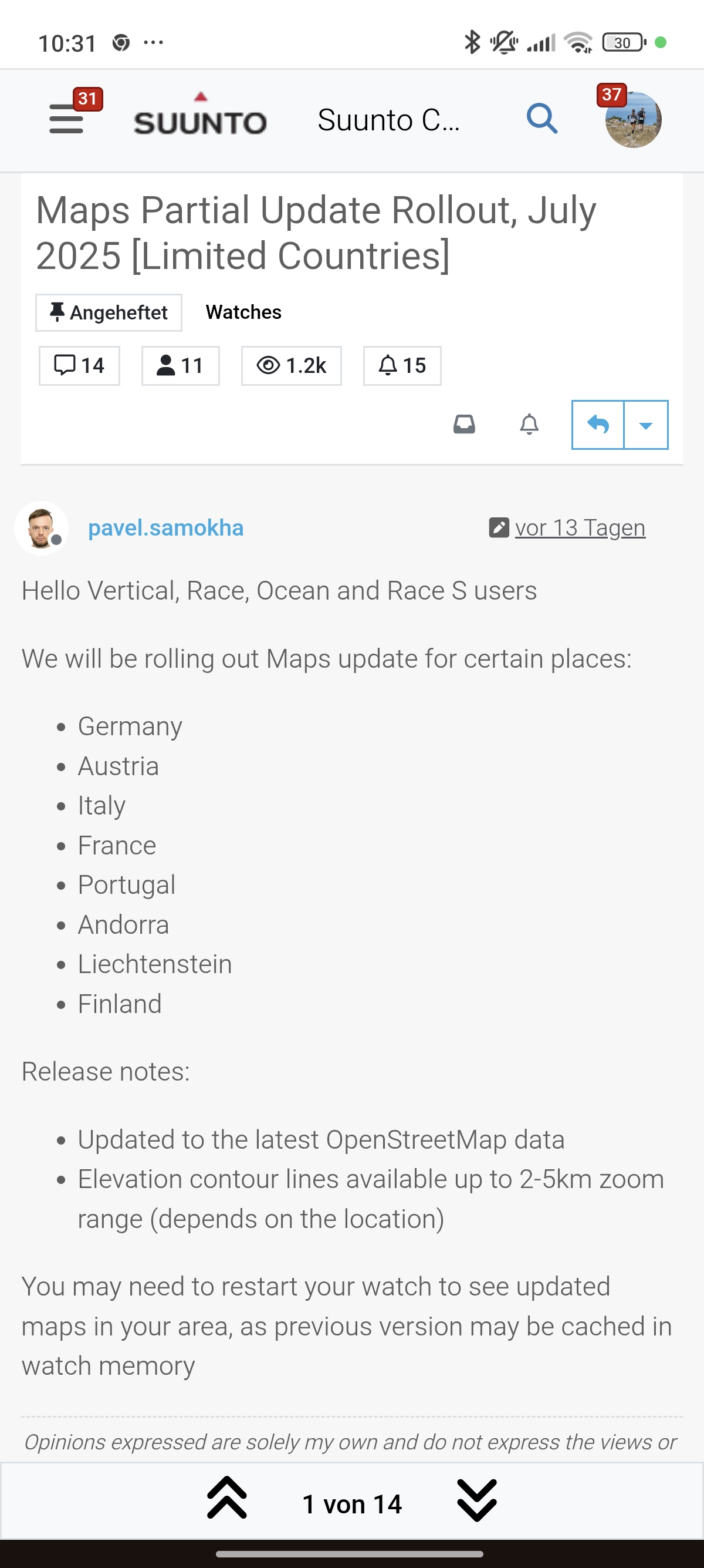
Maps Partial Update Rollout, July 2025 [Limited Countries]
-
Hello, it’s been 7 months since the last update for the french maps on m’y vertical.
I can’t see any new updates. I live in South France.
Is it normal? -
-
@GiPFELKiND
 Thanks…I can read.
We are the 19th of July and some french users had already the map update. -
@Kramble I live in Türkiye. The current map doesn’t even show the main street in front of my house
") So I don’t have any hope for the update.
So I don’t have any hope for the update. -
The selection of map sections is still a challenge. In Germany, I can’t download any of the federal states in their entirety, and the divisions within the federal states are completely arbitrary and incomprehensible.
Why not download 100 km around the current location or a selected point on the map? Or draw a rectangle and download the covered area? There are simply better solutions than the current one.
https://www.instagram.com/moves.are.life/
Suunto Vertical Black Lime
Suunto 9 Peak Pro Black
Suunto Spartan Ultra Stealth Titanium -
Yes, it’s a shame because one of the major advantages of OpenStreetMap vector maps is that updates can be automated. However, it seems that Suunto does it manually

-
@pilleus totally agree, it is OK if you are in your home region (for me anyway) but when you travel it is so hard to work out which maps… I’m of to Scandinavia for my summer holidays and it isn’t easy working out which maps I need! Hopefully I have them all…
On the plus side the maps are super responsive.
-
@Audaxjoe you have so much space in your watch, so you can load füll scandinavianemaps. Then you are sure you have all.
-
@GiPFELKiND I more or less have
I went across Spain early this year and missed one region and ended up with a black map 

 ️ Trying to make sure I don’t make the same mistake again.
But there must be a better way of selecting region… A map you can just click regions on maybe.
However in the grand scheme of things I can see why it isn’t prioritised.
-
@pilleus yes, you can download the federal state of Sachsen in a whole.
Very easy.
But otherwise I agree and Suunto is currently looking at different ways to select the maps to load. -
@pilleus the circle around the location seems nice-ish … but as I prepare my vacation at home it does not help me that much … so I had to learn a lot about the naming convention if some European nations.
The German maps are mostly downloadable as compelt federal states, which is rather easy for a german (most probably not for non-germans who won’t know the difference between Saarland and Schleswig-Holstein). Only a few regions are aub-divided, probably because of the terrain etc. But I think, too, that a graphical selection on a map would be helpful … for each nation. -
@pilleus said in Maps Partial Update Rollout, July 2025 [Limited Countries]:
The selection of map sections is still a challenge. In Germany, I can’t download any of the federal states in their entirety.
The truth is that you can download 13 of the 16 federal states in their entirety… Only Baden-Württemberg, Nordrhein-Westfalen and Bayern are divided in smaller parts…
-
The problem is that it’s a challenge to find the maps in an unknown area or country. Why is there no possibility to search for a city? Or to download the area the cursor is set on a map? Or the GPS is located?
For me it’s a poor solution to handle the administration of needed maps.
-
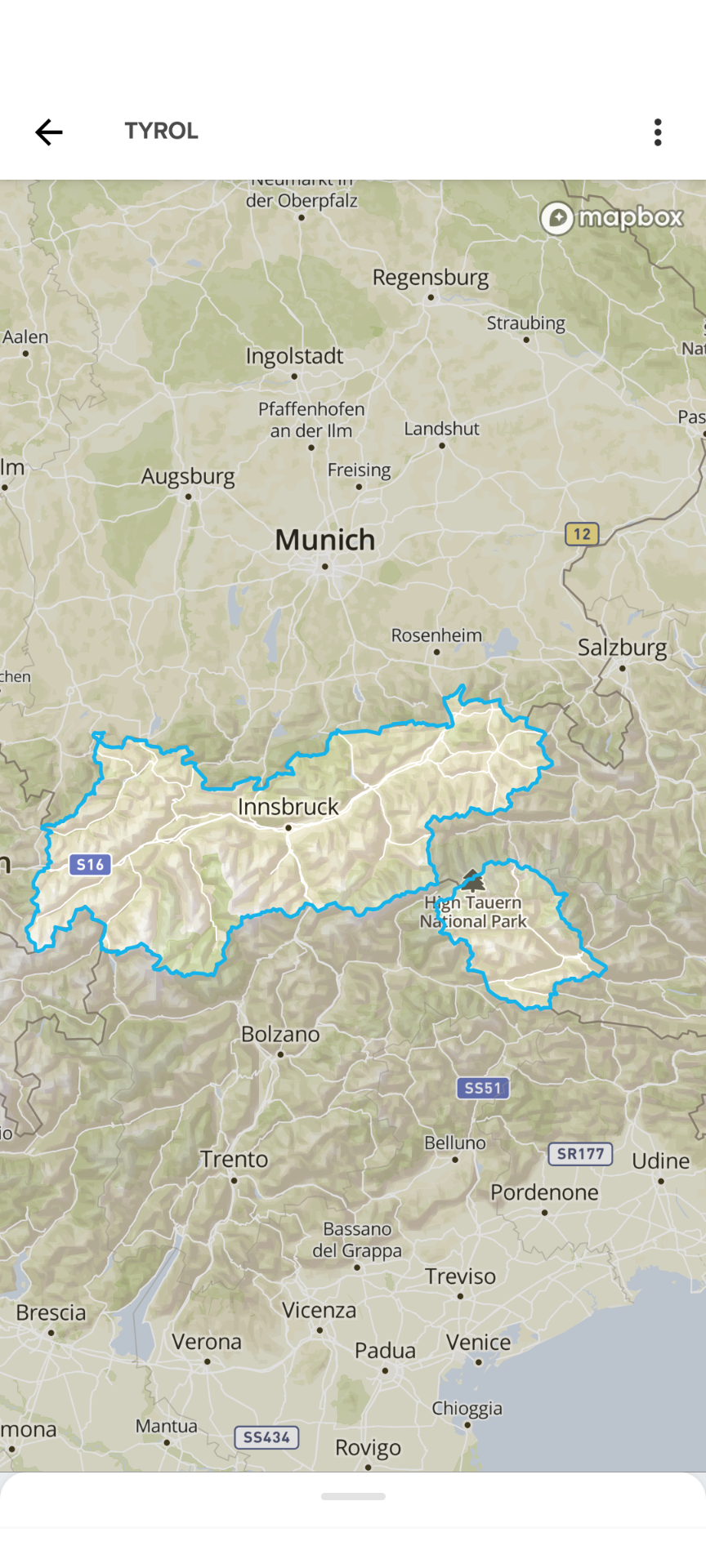
My bike tour is planned from Regensburg via Salzburg, Innsbruck, Reschensee, Meran, Gardasee, Verona to Venedig.
The total area is shown on the map I attached out of Suunto app.
Tyrol (if I choose it) is shown as a part of the route. Why not the names of all needed parts of the map around Tyrol so that I can download these maps without searching for the correct names? These parts are provided by Suunto, but I need to search and find out the correct names to download.
Or just the option to download all needed parts of the map shown on the screenshot?
-
@pilleus yes, there are different ways to define map regions to download.
Tiles, circles, rectangles on a map, maps needed for a planned route and others.As written above: Suunto is currently working on this.
t6, S6, Elementum Terra, Ambit 3 Sapphire, Spartan Ultra Copper, Traverse Alpha, S7 Graphite LE, S9B Ambassador, S9P Titanium, S9PP Titanium, Vertical All Black, Race Titanium Charcoal, Race S Titanium Courtney, Run Lime, Race 2, Vertical 2 Titanium
-
@pilleus Why are you telling me all this? I just pointed out that the mentioned part of your post was totally wrong.
-
@Egika said in Maps Partial Update Rollout, July 2025 [Limited Countries]:
Suunto is currently working on this.
I don’t meant to be boring, but hope that someone is also working on checking the map accuracy.
As already reported, the SA seems to be using a layer of OSM that contains a lot of artefacts:
SA on left and, OSM with “Cycle map” layer on the centre (showing both the same wrong feature), and the OSM with “Tracestrack Topo” on the right, which shows the correct topography: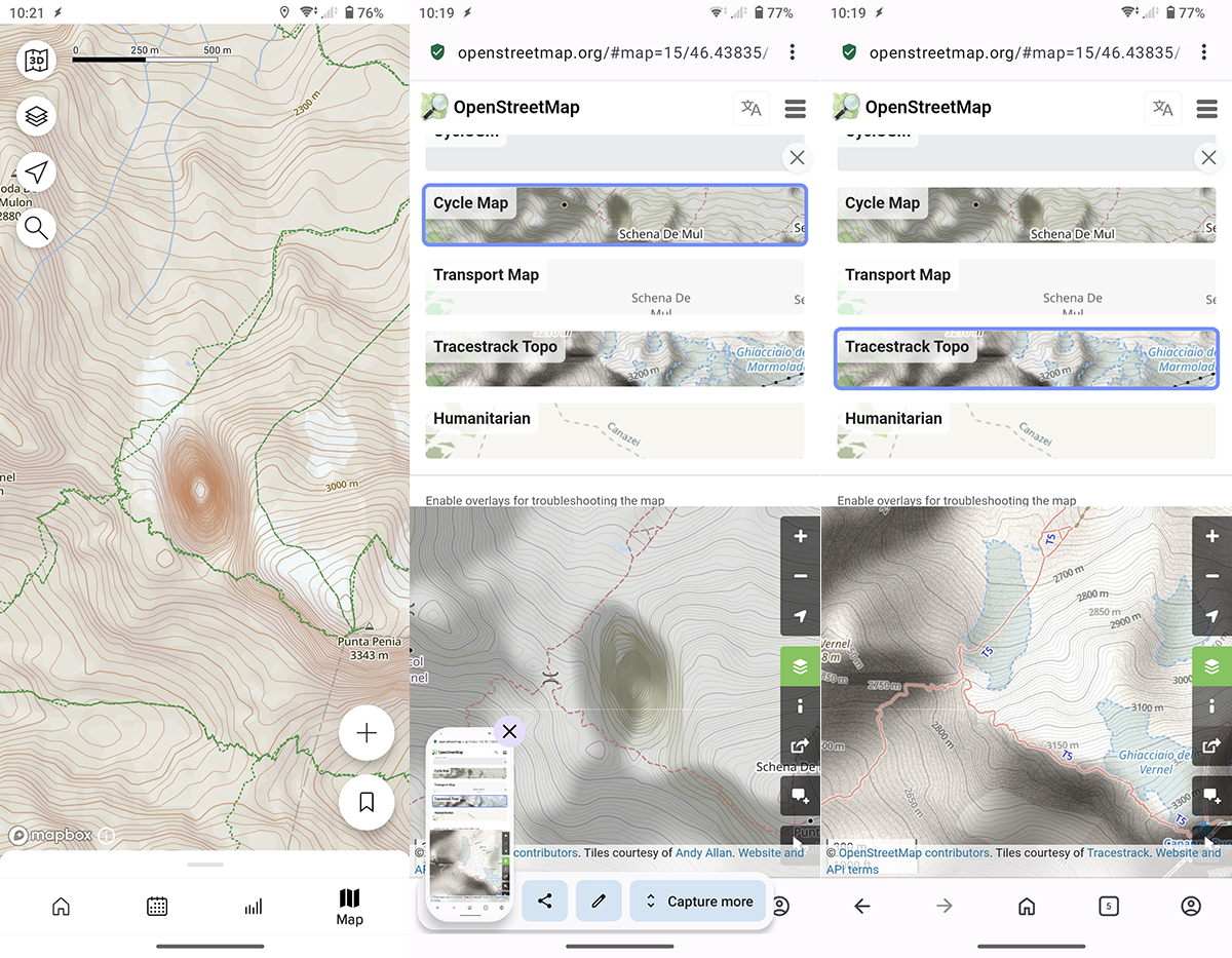
The Dolomite area is full of this kind of errors (read: fake depressions), which are present only on the “Cycle Map” OSM layer. In some places these artefacts completely distort the real topography, causing the maps shown by SA to be wildly inaccurate.
-
I’ll quickly comment on some raised issues, but if you want to continue discussion on any of it - please create separate topic.
- Limited update schedule. Due to cost/resource/validation reasons. Known and should be improved in the future.
- Inconvenience of region selection for some countries, especially as a destination. Known, hopefully will have graphical way to select in the future.
- Elevation contours is not perfect in some places? This is a complex subject. Suunto uses globally available digital elevation models (DEM) for watch maps, Suunto App uses Mapbox data (no idea what exact elevation model do they use, but anyway it’s not related to watch maps updates). While improving elevation model (specifically for route building) is important topic we’re unlikely to have resources to verify and fix specific places everywhere in the world.
Again, please here comments only related to the update. If you have any suggestions or issues you want to report - it should be in the dedicated topic, existing or new.
Opinions expressed are solely my own and do not express the views or opinions of my employer
-
Sorry for capturing your thread with this discussion. May be you can move it to a new topic. 🫣
-
@pavel.samokha said in Maps Partial Update Rollout, July 2025 [Limited Countries]:
This is a complex subject. Suunto uses globally available digital elevation models (DEM) for watch maps, Suunto App uses Mapbox data (no idea what exact elevation model do they use, but anyway it’s not related to watch maps updates).
it is definitely odd for me that watch and SA have different map sources, since they are parts of the same ecosystem: a Suunto user draw a route in SA and then send it to the watch, but nobody can tell if the maps shown by the two (watch and SA) are the same in that area … WOW(1)!
While improving elevation model (specifically for route building) is important topic we’re unlikely to have resources to verify and fix specific places everywhere in the world.
none at Suunto cares if thousand of his costumers by opening the SA will find wrong maps in one of the most frequented area along the Alps … WOW(2)!
I don’t think that this is good for the Suunto’s reputation, but if this the policy of the company I surrender, will no more bother the forum about that.
Sorry for the OT.
Hello! It looks like you're interested in this conversation, but you don't have an account yet.
Getting fed up of having to scroll through the same posts each visit? When you register for an account, you'll always come back to exactly where you were before, and choose to be notified of new replies (either via email, or push notification). You'll also be able to save bookmarks and upvote posts to show your appreciation to other community members.
With your input, this post could be even better 💗
Register Login