Software Update 2.43.8/.12 (2025 Q2)
-
@Artus-Diver (@ or anyone else swimming a lot) Can anyone who uses their watch for swimming confirm if there are any improvements to the swim distance / style detection algorithm? And how the swim drills app works?
-
@kriskus @Artus-Diver
I’m also very interested in this, as I won’t be able to get into the pool until next week. I’m mainly interested in whether it calculates the pool lengths correctly breastrokes. Ďakujeme -
Did I read somewhere that there were going to be new watch faces coming out soon not attached to the update, but following soon after?
Suunto Vertical, Race, Race 2, Race S and Run. Rocking the Vertical 2 Titanium at the moment.
Garmin: Fenix 7X, Epix Pro 51mm, Forerunner 265.
Coros: Pace Pro, Apex 4 -
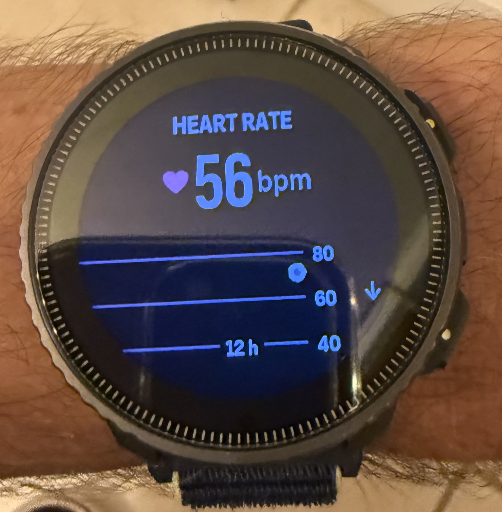
I’m seeing the issue with the HR graph not working in the watch also. Data sent to the app seems fine but the watch only shows current HR.
-
@ElectronBadger said in Software Update 2.43.8/.12 (2025 Q2):
@pavel.samokha said in Software Update 2.43.8/.12 (2025 Q2):
@TrailEyes yes, hotfix should come. 2.43.12 probably
Installed 2.43.12 on my SV. The problem with manual laps not being displayed properly is still there

My mistake, sorry. After installing the update, settings for activities got reset to defaults and autolapse became active. When I disabled autolapse for the activity, manual lapses are displayed correctly.
-
@duffman19 said in Software Update 2.43.8/.12 (2025 Q2):
On the current software, trails (footpaths, sidewalks, etc.) disappear at the 500m level. Service roads (driveways, parking lanes, alleyways, etc.) disappear at the 1.00km level. And residential roads disappear at the 2.00km level.
It is even worse in imperial units as trails disappear at the 0.2 mile level, which is just 320 meters.
@Dimitrios-Kanellopoulos, I apologize that I let some of my frustration through, but nevertheless this should have been caught during beta testing.
Since I keep finding issues, maybe I should apply to be a beta tester. I am a very experienced software developer myself with keen attention to details. I’ve noticed this issue the very first time I used maps on a trail run. I have two Suunto watches (Race and Race S). I offer to use one of them for early beta testing. Please sign me in or let me know how to apply!
Suunto: Ambit, Ambit 3 Peak, 9 Baro, Race S, Race Ti, Vertical 2 Ti
Garmin: Forerunner 210, Forerunner 610, Fenix 6X, Fenix 7X Ti -
No problems with either update on my Suunto Vertical. Lots of hiking with it of planned routes. Sleep data good. Anyway. Appreciated these regular updates from Suunto.
-
It seems to me that something has changed on the altitude measurement.
for similar paths and knows tracks, i get lower altitude measurements despite having similar elevation gain (ascent descent is quite ok). At ±600m altitude with 170m ascent I still get similarish ascent but with significantly lower altitude measurements! the map lines indicate that previous measurements where right , but the recent ones are not (see below)
current shows
map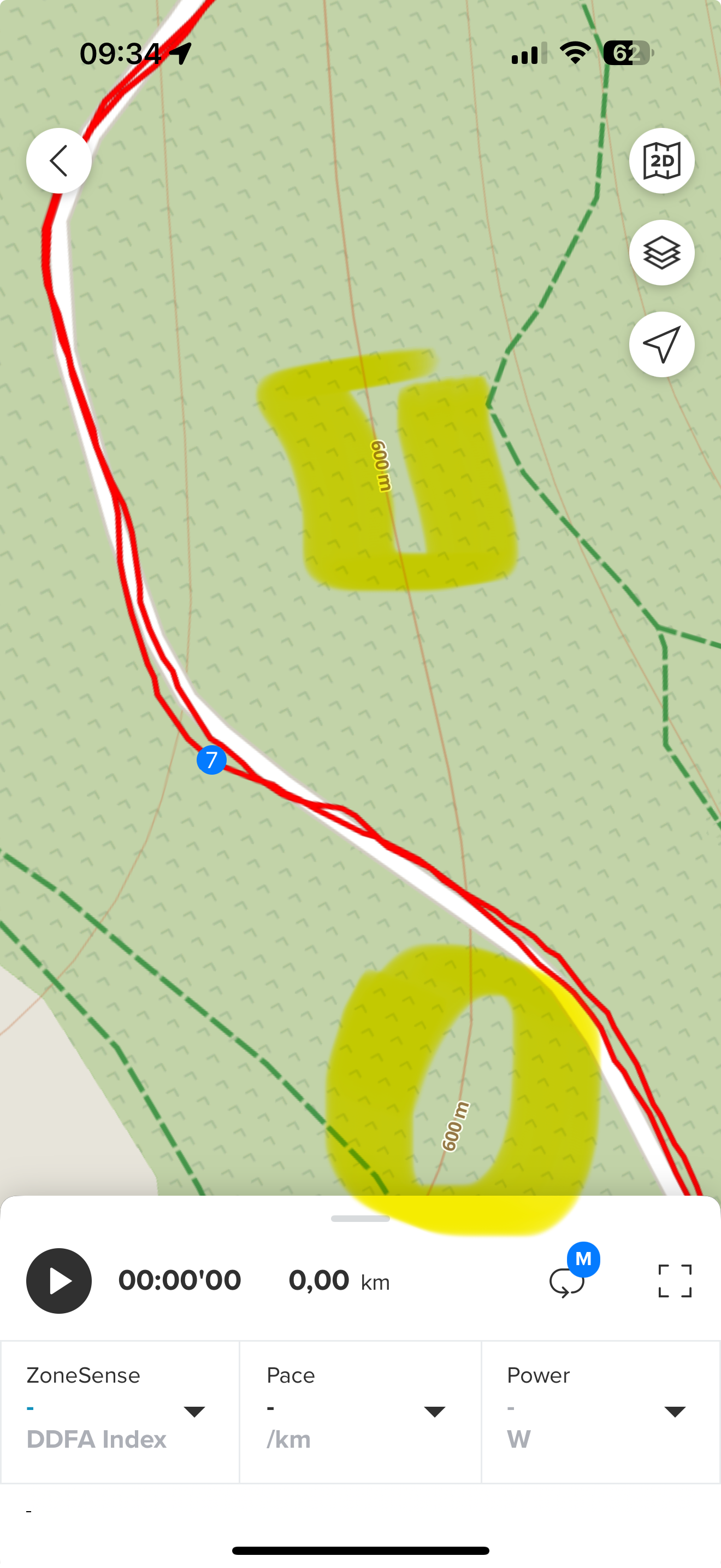
-
After updating, you must calibrate the altimeter.
Previous calibrations are lost when updating… -
@larrybbaker I had to soft reset watch. It solved issue.
-
@sky-runner as you already see in this thread, not everyone is unhappy with the levels of detail in the map zoom levels.
So it’s down to perspective.
I understand that you don’t like it - which does not make it a bug.
Whenever there is change, some people are disappointed, while others are fine or happy.
Remember the change from revolving complications to fully customizable but fixed?t6, S6, Elementum Terra, Ambit 3 Sapphire, Spartan Ultra Copper, Traverse Alpha, S7 Graphite LE, S9B Ambassador, S9P Titanium, S9PP Titanium, Vertical All Black, Race Titanium Charcoal, Race S Titanium Courtney, Run Lime, Race 2, Vertical 2 Titanium
-
@Jordi-C said in Software Update 2.43.8/.12 (2025 Q2):
After updating, you must calibrate the altimeter.
Previous calibrations are lost when updating…I think it is automatically adjusted after 5-10min after the exercise is started
-
@VoiGAS a drill mode that allows for manual entry of distance would solve most all problems with swim-tracking
-
@sky-runner no worries. As I said I agree with you. And I understand.
-
@SailingP I noticed that now also. Thanks. Will
See if it is fully resolved now. -
@Egika said in Software Update 2.43.8/.12 (2025 Q2):
I understand that you don’t like it - which does not make it a bug.
I agree that it doesn’t make it a bug. But this shift in rendering makes maps less usable when running in wilderness on trails. When trails disappear after zooming out as little as 500m in metric or 0.2mi in imperial, there is pretty much nothing left of the map. What’s the point then? Suunto is one of the major sponsors for UTMB, so I thought Suunto sees trails runners as one of their core user groups. The design of packaging for their watches conveys the same message - that this is an adventure watch for exploring trails.
Let’s hope this was not intentional and will be fixed soon.
Also, I wanted to use this opportunity to mention that I am also unhappy with the choices of colors on all maps, including the high contrast one. Trails aren’t contrast enough, like dark green on green in the light map or grey on black in high contrast one. Even when trails are still visible, for example at 500ft or 200m scales, they are nearly invisible to my eye due to their width and poor contrast. So with this change, I can still see trails well only at the 200ft scale that covers at best only about 20-30 seconds of running.
Suunto: Ambit, Ambit 3 Peak, 9 Baro, Race S, Race Ti, Vertical 2 Ti
Garmin: Forerunner 210, Forerunner 610, Fenix 6X, Fenix 7X Ti -
@sky-runner I agree with your statement. I always found it very useful to see trails when in unknown terrain to orient myself. I hope they are fixing it with the next update. And maybe an option to adjust how many feet it meters turn by turn gives a warning. It really makes a difference when biking vs running.
-
Is my understanding correct that with the new ZoneSense data fields it is not required to use the SuuntoPlus app now?
-
Any info on why the 9PP is not getting the update?
-
Coming back to the altitude measurements issue
- leaving the watch idle , it should NOT change either altitude nor the barometric pressure … at the moment a storm (which should have triggered the alarm ) changed both the altitude measurement and the barometric pressure , but that way both indicators were somehow wrong
Hello! It looks like you're interested in this conversation, but you don't have an account yet.
Getting fed up of having to scroll through the same posts each visit? When you register for an account, you'll always come back to exactly where you were before, and choose to be notified of new replies (either via email, or push notification). You'll also be able to save bookmarks and upvote posts to show your appreciation to other community members.
With your input, this post could be even better 💗
Register Login