Let's talk about the climb guidance feature or often the lack of thereof
-
“Suunto’s Climb Guidance prepares you for the terrain ahead” proclaims this article on suunto.com. Well, based on my experience I have to disagree. I wanted to discuss it in this thread.
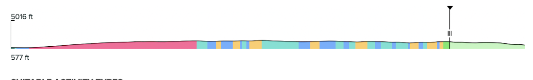
At the top of the article there is screenshot of Suunto App that shows climbs during the planing phases in the app that looks like this:
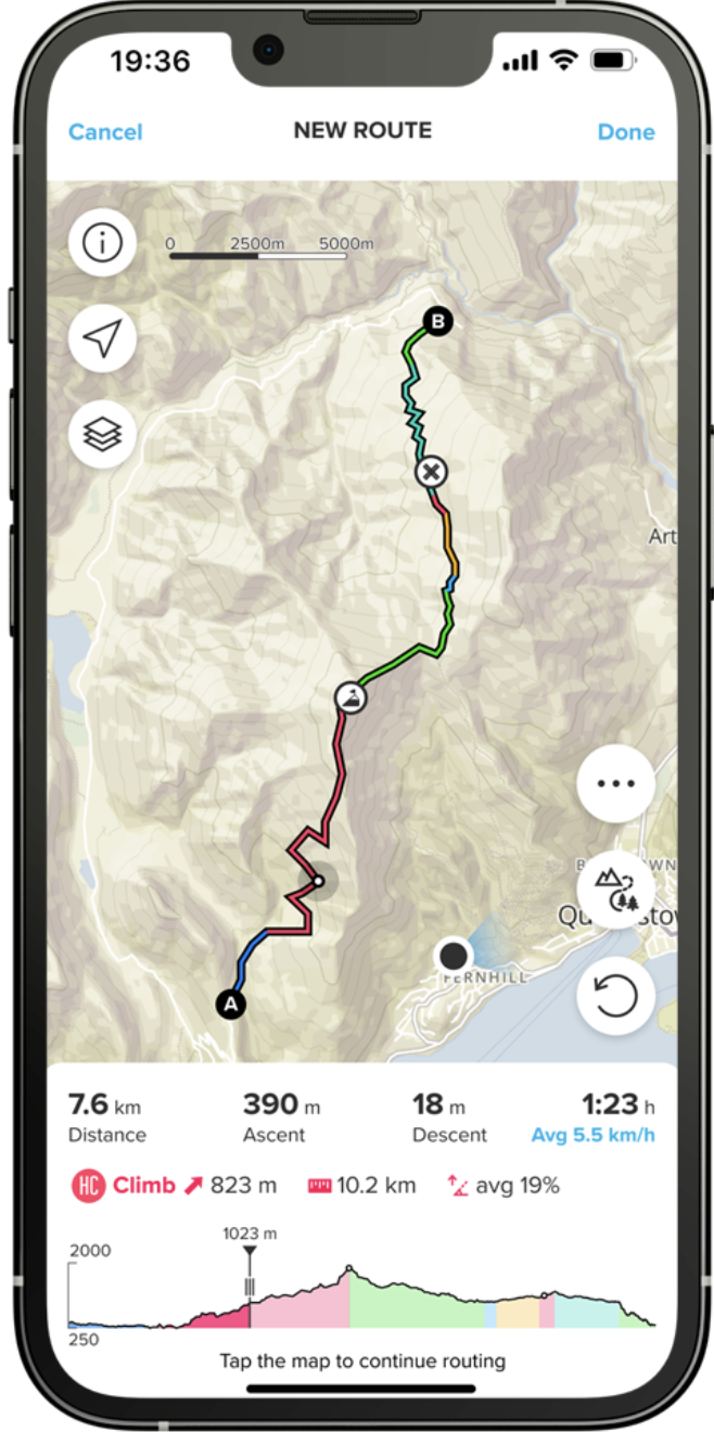
Please note how clean the profile looks with just a few very distinct phases - a long climb followed by a long descent, then some slight uphill, and finally a downhill. Perhaps that is fine for a very short 7.6km run. Looking at numbers in the screenshot the terrain seems to be rather steep, and the climb guidance feature works decently well on a very steep terrain.
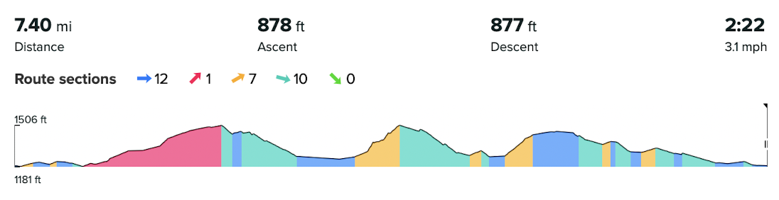
But let’s take a looks at what users like me may encounter in reality. Here is a profile from my recent 100K race - note that the projected total ascent is 11079 feet:
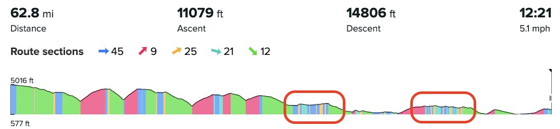
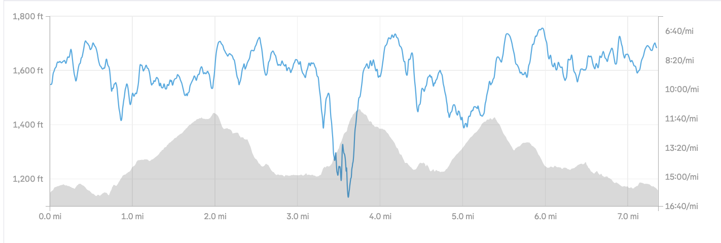
Here is what the actual elevation profile was after finishing the race - the actual total ascent was was 13055 ft, which is 18% more than projected:
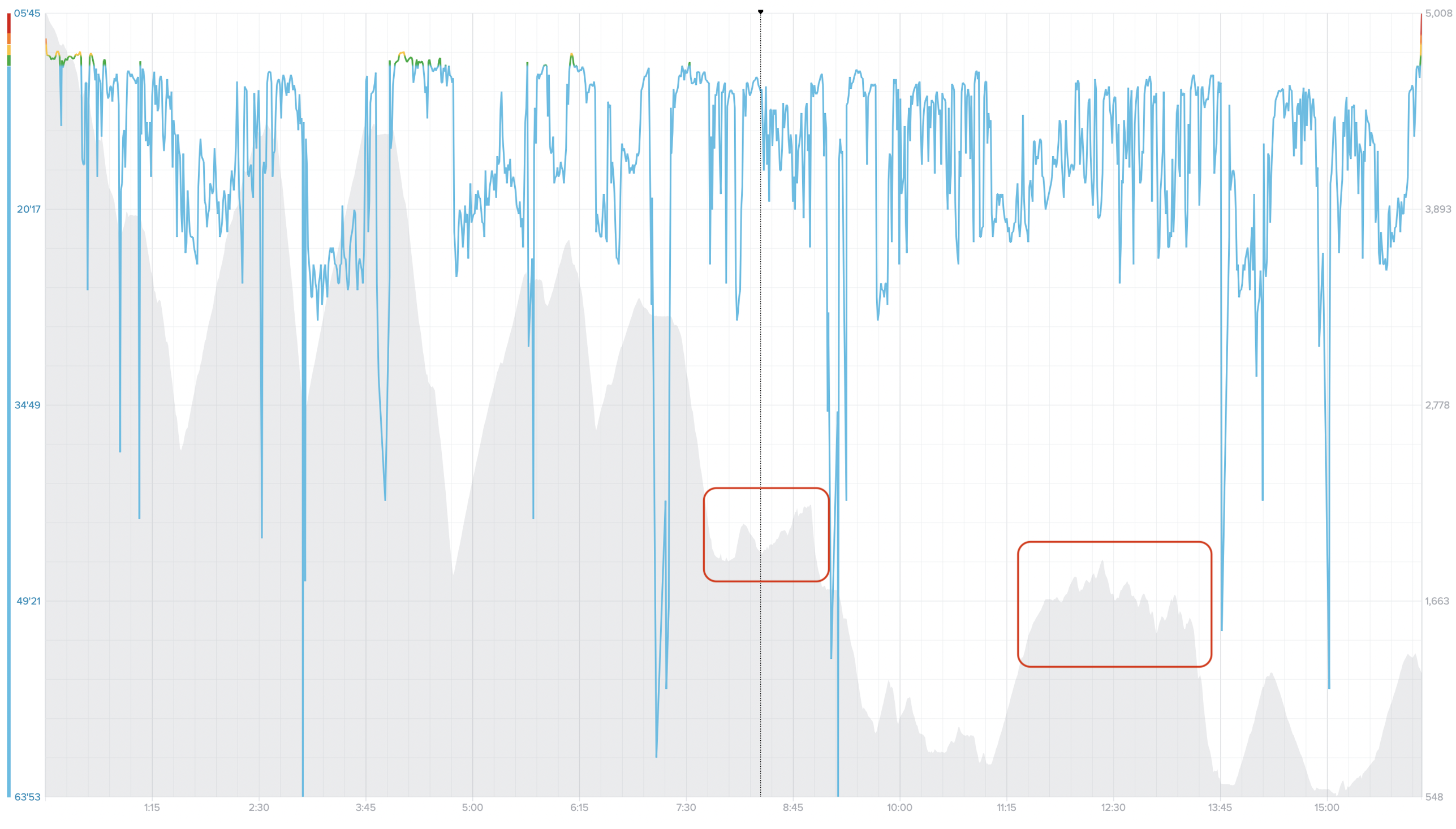
Now let’s zoom into the two segments where I had the most frustrating experience with the climb guidance vs. what I actually experienced - they both are highlighted on the pictures above.
[1]:
[2]:
What we see in this zoomed in climb guidance profiles from the app and what I have experienced during the run is that it tends to break the elevation profile into sections based on average grade rather than the actual lowest and highest points in the route. What that means is that:
- Every climb always start a bit too late - usually I am already climbing for 1-2 minutes before the climb starts in the climb guidance, and that is worse on rolling terrain. That is probably because it takes some time for the average grade to change.
- Similarly, every descent ends too early. Often it tells me I have reached the end of the climb, but in reality I may still be halfway through the climb, perhaps with a bit less steep part of it ahead of me.
- It has a tendency of breaking long climbs into seemingly arbitrary sections. For example it may tell me a tiny 27 feet climb is coming. But then when it ends it immediately shows another tiny climb, then another, even though they all a part of a longer climb. It may arbitrarily break a longer climb into multiple fairly short sections of steep climb, less steep climb, a flat section which is in reality continues climbing, then another less steep climb, etc.
All of the above is quite frustrating when you are already multiple hours into an ultramarathon race. Consider the following. I don’t care whether a 5% uphill climb section changes to a 10% uphill - I don’t need this broken up. I need to know further ahead - when the overall climb ends. I need to know, for example, whether to retrieve and my hiking poles or to stash them - that takes some time and effort. I need to know how to time my nutrition to the climb. I need to have a real guidance to know what’s further ahead rather than just 0.2 mile ahead. I’d rather have my watch showing me a 3 mile rolling terrain section with general uphill trend then a bunch of tiny climbs, flat sections, and descents.
This is especially visible in the first highlighted section. You can see on the actual profile that that was 2 fairly distinct climbs, but according to my watch it looked like a mostly “flat” section with just a few very short gradual low grade uphills. Wrong! The second highlighted section is perhaps trickier, but even in that case there are some clear uphill and downhill trends. For example, the first small climb was in reality a continuation of the previous big climb as the flat section between them was fairly short. There is absolutely no reason to break that part of the profile into 30 (!) distinct segments - that’s not useful at all! Some of those segments were so short that the watch didn’t even notify me about them and they just got skipped! Because of that, for example, I observed, a gradual climb segment ending and being immediately replaced with another gradual climb!
Furthermore, the overall elevation profile for the entire race was completely unusable on the watch at this scale. It lacked details so much that even the last two larger climbs that are nearly 1000 feet each were nearly invisible on it. But at the same time, breaking it into sections doesn’t help because it is impossible to scroll forward to see what’s coming next.
To summarize, what would really improve the experience is the following:
- to have a bit of a bigger picture where you can see clearly what’s coming next with useful details. This can be achieved by a combination of zooming and panning of the profile similarly to how we can zoom and pan the map. Or perhaps we should be able to scroll through individual segments in the climb guidance.
- When in an ultramarathon on foot, a specific grade of a climb less important than knowing where the overall climb starts and ends because the race execution strategy depends on that. Perhaps, how exactly the overall profile is broken into segments should be proportional to the overall distance, and it should reflect the trends rather than tiny changes in the grade. Then furthermore, each climb section may use multiple colors to convey the grade within that bigger climb - that’s what Garmin does and that works much better. If if there is a small downhill within a much larger climbs, Garmin doesn’t break it into two separate climbs but shows flat or downhill section within a larger climb using color coding.
I’d like to hear what experience others have had with the climb guidance feature. Do you think the current implementation needs some further improvements?
Suunto: Ambit, Ambit 3 Peak, 9 Baro, Race S, Race Ti, Vertical 2 Ti
Garmin: Forerunner 210, Forerunner 610, Fenix 6X, Fenix 7X Ti -
@sky-runner Must be terrain dependent as I have somewhat the opposite experience. My long and steep climbs are often interspersed with somewhat flatter sections but show one long climb in guidance. I have not experienced late or delayed notifications.
-
I have already reported and noticed that i suspect that climb guidance is based on « distance from start » of the route instead of « current gps position ».
My feeling is that if I start a climbing section witch start at 25km from start of the route, and if the watch has already mesures 25km few meters before the gps point where the climb was supposed to start, then the climb guidance for this climb willl start at the 25km point mesured by the watch.
From my experience the further you are in the route, the most is guidance « delayed ».
But I have never take time to really verify that feeling, I may be wrong (@isazi i remember you said to me that I was mistaken about the behaviour). -
A few more details / questions I wanted to add to this discussion.
Here is the route profile from my today’s run - as planned:
Here is how it actually was recorded and shown in Strava - I ran the route exactly as planned:
What I don’t find right:
-
Why does the second climb show as yellow (uphill) vs. the first climb shown as red (a true climb)? I thought that was based on the grade! But the second climb is clearly more steep and we can see that in Strava’s screenshot. The app shows the first one as being 4% (321 ft in 1.4 miles). The app doesn’t even show the grade for the second one because it is a mere uphill, but in reality it is about 11-12% (248 ft in 0.4 miles according to Suunto App route shown above). If that is based on the distance or some other criteria, I find that arbitrary.
-
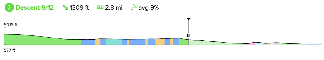
Why the third climb is so different between Suunto App and what was actually there. During the run, the yellow uphill segment had finished about halfway through the climb, and then it showed the rest as a “flat” blue segment, but in reality I continued running uphill, although it was a bit less steep. The shape of the profile looks quite different too between Suunto App and Strava. But what I really want to see in the climb guidance is an entire climb being included - from the lowest point to the highest point. If the grade changes during the climb, that can be shown with the color the way that is done in the overall profile. In other words, I think the 3rd climb should be shown on the watch as something like this:

Similarly, the first downhill should be shown as this:
Suunto: Ambit, Ambit 3 Peak, 9 Baro, Race S, Race Ti, Vertical 2 Ti
Garmin: Forerunner 210, Forerunner 610, Fenix 6X, Fenix 7X Ti -
-
@sky-runner Is think a short uphill shouldn’t be a climb but a uphill section. So the second climb might be steeper but it is short. Only my opinion of course.
Funny last year I cycled 2500km across Europe with a couple of friends. We had Suunto, Garmin and Wahoos in the group.
I found the Suunto easily the best as it didn’t keep saying every uphill section was a climb, but possibly for less experienced riders it might be a bit harsh. If Suunto said it was a climb you remember it!
Wahoo seemed to have everything as a climb!
Garmin in the middle.
Checking in the morning before leaving for the day the Sunnto might show 3 climbs, Garmin 10 and Wahoo 30! But for me the Suunto was the most useful.
I did think for a lot of people the way Garmin and Wahoo report climbs would be more appreciated but I only wanted to know if it would be a proper sustained uphill section.
The Wahoo is pretty good at making one long climb with a flat/downhill section one climb. The Suunto is inclined to split the climb. I can’t remember how the Garmin got on.
-
@sky-runner If you don’t mind sharing, where are you running? I’m in North America and I’ve found the background elevation data in the Suunto App to be pretty poor. It doesn’t feel as granular as other apps I’ve used, often giving me straight line elevation changes where there should be obvious rolling hills.
However, I planned some routes in the UK last summer and was surprised by how much more accurate the elevation data was for that area. Perhaps sub-par elevation data is partly to blame for our experience with CG?
Further, climb guidance just doesn’t feel as though it was designed for the terrain I run on - rolling hills with often short, steep climbs. In the valley where I live, the steepest climbs are 10-12% over 0.5-0.75 mile. These certainly feel like climbs to me, but I’ve yet to have Suunto label one as such on any route in my area.
I agree with almost all of your assessments regarding CG. Seems it was designed for more mountainous terrain with longer climbs and descents. I haven’t found it useful in my area and simply don’t use it anymore. I think Garmin still has the edge here.
Vertical Ti / S9PP Ti / S9P Ti
-
@duffman19 I mostly run in the Seattle area. We can some proper mountains here, but I also run a lot on rolling terrain.
My first example in the beginning of this thread was from UTMB Canyons 100k race in California. The course partially overlaps with the Western States course. It is worth mentioning that Suunto is one of the main UTMB sponsors. While the climb guidance was useful in the first part of the race, which is more more mountainous, my experience using it in the second part of the race was quite frustrating as I described above.
My second example is from Cougar Mountain in the Seattle suburbs which is one of the most popular areas for the local trail runners.
As a trail runner, I don’t find the current Suunto’s Climb Guidance implementation particularly helpful. It is better than nothing but in many cases it doesn’t feel right. Breaking the overall profile into differently colored segments based on the grade is a nice touch, but one climb or one descent doesn’t have to be exactly one colored segment. With that, the color should represent only the grade and not other arbitrary criteria like the distance or amount of elevation gain. That is basically what Garmin does, and in my opinion that is much more helpful than Suunto’s version.
-
@duffman19 I did a bit more reading, and I am now fairly certain that Suunto categorizes the climbs using cycling climb categories, as mentioned here:
https://us.suunto.com/blogs/blog/suunto-s-climb-guidance-prepares-you-for-the-terrain-aheadThe climb categories are explained here:
https://climbfinder.com/en/climb-categoriesThe climb points are calculated by breaking the distance into 100 mile segments than then adding together the grades. That’s why short climbs aren’t categorized by Suunto as “red” even if they are very steep. To show an uphill as a climb it needs to be at least category 4 according to Suunto article, which means it needs to be at least 75 points. But 75 points is at least 500 meters at 15% grade or 750 meters at 10%. That is quite difficult for running.
Using cycling climb difficulties for running is misguided approach in my opinion.
-
@sky-runner sounds good. Thank you very much for information. Hopefully suunto will change this for trailrunning and hiking.

Hello! It looks like you're interested in this conversation, but you don't have an account yet.
Getting fed up of having to scroll through the same posts each visit? When you register for an account, you'll always come back to exactly where you were before, and choose to be notified of new replies (either via email, or push notification). You'll also be able to save bookmarks and upvote posts to show your appreciation to other community members.
With your input, this post could be even better 💗
Register Login