Navigation on an in and out trail starts at the wrong end
-
I tried using the new climbing guidance on an in and out trail I did and it didn’t work at all. It started me on the end of the trail instead of at the beginning. So waypoints became pointless. Then it started the descent guidance when I was still climbing upwards. And then it just stopped tracking the anything on the map as it didn’t see it as me reaching the summit and going back down even though I went back where I had mapped it. One one trail where I start in the middle then do peak A, go back almost to the start and then to peak B and then back to the start it showed me starting in the middle and going up the descent on peak A on the elevation plot. The weird thing was that the arrows on the map showed everything the right way. I had also mapped everything in the order I ran it but that didn’t help. I contacted support and they didn’t help at all just saying it’s a known issue. I don’t understand how suunto keeps releasing such untested software. Every update I’ve gotten had made the watch worse. It seems like a feature that doesn’t work what so ever if the trail isn’t a straight point to point trail.
-
@Niclas-Brundell There could be problems with your route, I would re-create it. I have done many routes in testing this firmware and not seen your issue.
-
@Niclas-Brundell a fix for this issue should be available soon, as far as I heard
-
@isazi Hotfix time?

-
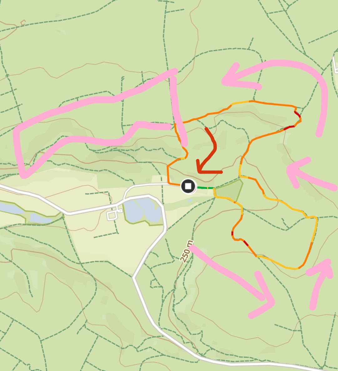
Today i did my first trailrun with the new Suunto climb Guidance. In my case i planned a route and follow this route. I was tired so i didnt follow the extra loop from my course and run the last 2 km in my route. This part is a Downhill and the Guidance didnt change to the Downhill Part. Cause in the original route i had still 5km to go. And i decided to Run not the extra loop. At this point the climb Guidance was completely false.
Let me explain with my Screenshot. The orange part was the tour i Run, this part was planned in Suunto App plus the pink part on the left Side. At the red line i go in the Downhill and run not the extra loop with the pink Line, why the Suunto climb Guidance was at this time fully false? Cause i didnt finish my route like planned? The red arrow line shows the Part (orange) i Run, and this was the ending part from my planned course. The navigation was correct and know that i make not the bigger Tour. But climb Guidance didnt work in this segment.

-
@surfboomerang as usual, I do not work for Suunto, but there may be a hotfix for some issues (including this one) coming soon. Plus, one new feature (let’s call it this way)

-
@isazi thanks! I used it on a point to point trail yesterday and it worked pretty well. Though I have noticed that whatever map suunto uses for elevation profile often shows a lower elevation than reality, and than what the map shows. Even though the map shows a peak marked as 2348m the climb assist shows max elevation at 2300 on the climb. I’ve noticed that on basically every climb. And I do think the map is more correct as the verticals altitude is always spot on with it. There’s also been a few times where climb assist will think the climb is over when it mellow out, and sometimes that I’m starting to go downhill even though it’s still going up
-
@Niclas-Brundell There are definitely some issues with out-and-back routes. I posted my observations here - https://forum.suunto.com/post/148013
It’s cool that the watch can reverse directions on a route automatically, but this seems to cause all kinds of problems when the route overlaps or starts and ends at the same location.
@Niclas-Brundell said in Navigation on an in and out trail starts at the wrong end:
There’s also been a few times where climb assist will think the climb is over when it mellow out
This has been an issue for me as well. I don’t live near mountains, but have lots of brief, intense climbs in and out of a valley (200-300ft gain over 0.5-1mi). I can’t even get Climb Guidance to admit these are climbs (always just “uphills”) even though there are sections with 20-25% grade. I think the issue is the background elevation data that SA is using. It’s just not accurate for my area. Garmin’s ClimbPro is scary accurate, though, and usually nails the apex of my climbs, whereas Suunto will think the “uphill” is over even though I’ve got another 50-100ft. ascent to go.
-
@duffman19 yeah I definitely think their background elevation data is pretty off. It doesn’t line up with the elevation markings on their own topo maps. The top elevation on the climbing guidance is always below that their own topo map says, and what my verticals barometer says when I’m there. Which makes it kind of useless if you don’t know that the climb is actually 100meters or more than the climbing guidance says