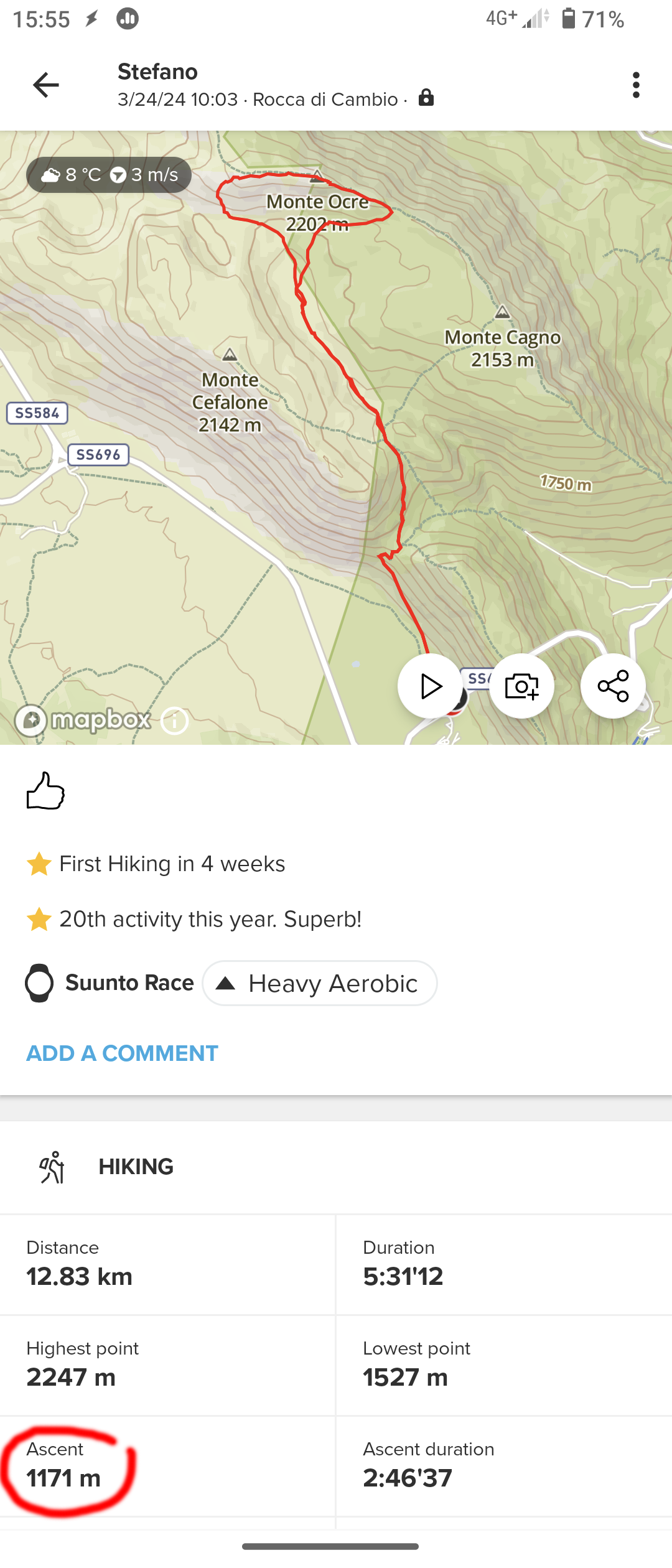
Wrong total Ascent/Descent values in Hiking Sport Mode
-
@SteM64 if you zoom in you may see a ton of small spikes, probably created by the wind pushing air into the baro sensor
-
the altitude is recorded only by the barometer?
Apart from spikes due to the wind, along an hiking day atmospheric pressure can vary a lot, this means that altitude and related values reported by the Race are unreliable(?), that’s bad! -
@SteM64 the altitude is recorded only by the barometer, but it uses the GPS to recalibrate in case the two reported values (from the two different sources) start diverging too much. This does not fix very short spikes unfortunately, only weather and uncalibrated starting altitude.
-
@isazi many thanks for the clarification!
However, I wonder why the Race doesn’t record the altitude from the GPS, which is in any case interrogated to get the position, instead form the barometer, it seems illogical to me. Maybe this saves battery? An option to let the user to switch between GPS and barometric altitude measurements would be great. -
@SteM64 recording altitude exclusively by GPS is inaccurate and far worse than the Race. What you have is wind affected barometer readings, which has happened to me and a few others as well. it must be very windy and a temporary solution is to cover the watch with a buff or jacket.
-
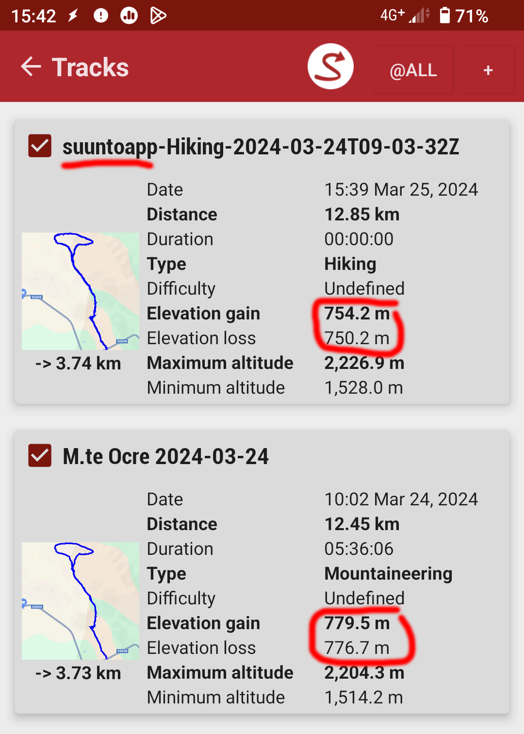
@Brad_Olwin Hi, I had the Race covered by two piles and a light windproof jacket, and I wore gloves too. In any case, by inspecting the altitude peaks near to top I estimated they can sum up to an altitude difference of few tens of meters. By exporting the GPX workout into Oruxmaps or an online GPX viewer (as gpx.studio) I get coherent Ascent/Descent values between about 730m and 765m, that is about 400m less that the 1’170m reported by the Suunto app. Maybe they use some running average/smoothing filters to eliminate spurious altitude variations? I guess the problem could be caused by the high sampling rate of the Race while operating in Performance mode: the GPX data show a 2s / 3s sampling rate, which is way too high for hiking/mountaineering, small errors in the altitude readings would sum up to hundred of meters at the end of the trip, if not correctly filtered away. Suunto should improve the data analysis for hiking/mountaineering sport modes, where correct altitudes are important.
-
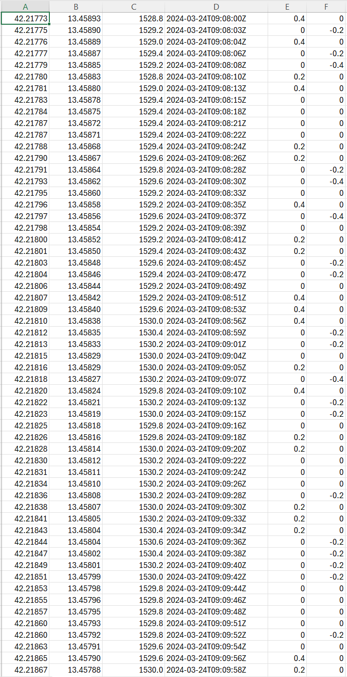
OK, I analyzed the problem in more details by importing the GPX data into a spreadsheet (Excel) and found some interesting things:
a) the altitude is given with a 0.2 accuracy, that is 20cm(!)
b) sampling rate is usually 2s
c) by summing all the positive/negative differences I get 1’417m for Ascent and 1’413m for Descent, that is TWICE the expected values(!)Is the barometric sensor of the Race so good to give an altitude reading with a 20cm precision? A variation of atmospheric pressure of 1 hPa (1 mbar) should corresponds to roughly 10m, so to evaluate 20cm a 0.02 hPa accuracy is needed, which is quite high.
In any case, since people move their arms up and down while walking, such “precision” is completely useless. By using hiking poles (as many people do) every step the wrist can easily move up and down for about 40 or even 60cm, depending on how much you push on the poles.
By averaging the altitude data over 1 minute, I get 776m for Ascent and 772m for Descent, values that are close the the expected ones.
Sampling rate and “accuracy” are both too high and cause an overestimation of total ascent and descent values. -
@SteM64
your mentioned arm movement is “filtered” by a threshold (not sure anymore about the value, but it’s reasonable…).
you will not see arm movement, pointing with fingers to mountain peaks, taking lunch out of your backpack nor will you count ascent by doing jumping jacks
-
@SteM64 I have already written in another thread that without some filtering of results, in sports such as hiking and mountaineering, the current results of ascents and descents in 9PP, Vertical and Race do not make any sense.
A little of strong wind and you can have an error of several hundred percent. -
@freeheeler said in Wrong total Ascent/Descent values in Hiking Sport Mode:
@SteM64
your mentioned arm movement is “filtered” by a threshold (not sure anymore about the value, but it’s reasonable…).
GPX files store altitude values every 2 or 3 seconds, with a resolution of 20cm, how can the software distinguish if I lift my hand to the sky for a while, or if walk up and down a big stone along the path?
The attached screenshot shows the altitude variations (last 2 columns) over 2 minutes, while walking from 1’528.8m to 1530.0m (+1.2m), positive and negative readings alternate often cancelling them out: the sum of positive differences is +6m, of negatives -4.6m, while the average over 2 minutes is just +1.4m.
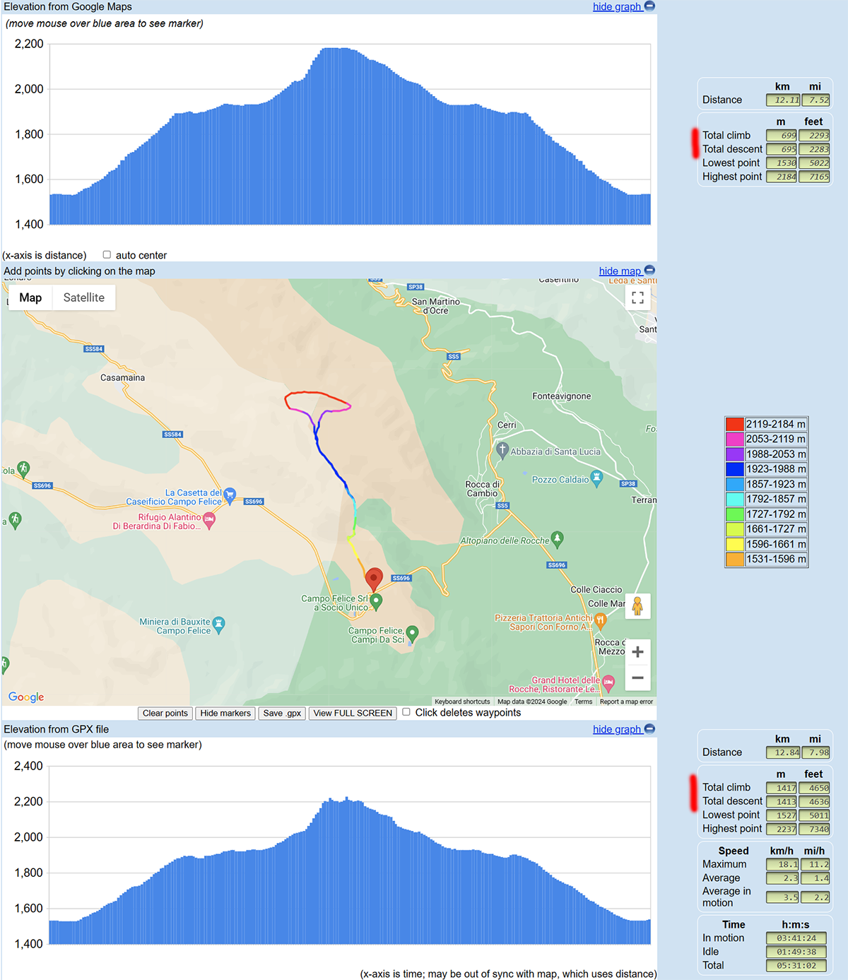
I suggest anyone who is curious to check to load their GPX file in: www.maplorer.com/view_gpx.html
that web page compares the elevations as derived from Google Maps (on the top), and the ones computed from the GPX file (bottom).
I will try to do a “slow” jumping jack when back at home and let you know what happens ;^)
-
@SteM64 Same problem for me. Watch sent to Suunto for repair explaining the problem, returned without doing anything writing that there is no problem.
On a short hike, without stopping and at a high speed, the data is correct, but as soon as my speed is low and I take breaks (normal on a hike), it’s nonsense. I find myself like you with double the ascent and descent values, notably permanent variations when stopped and bad altitude data.On a simple walk, stopping to chat with a neighbor, the altimeter varies, even though I am not moving. This walk gains around 45m, but the Race records 70m.
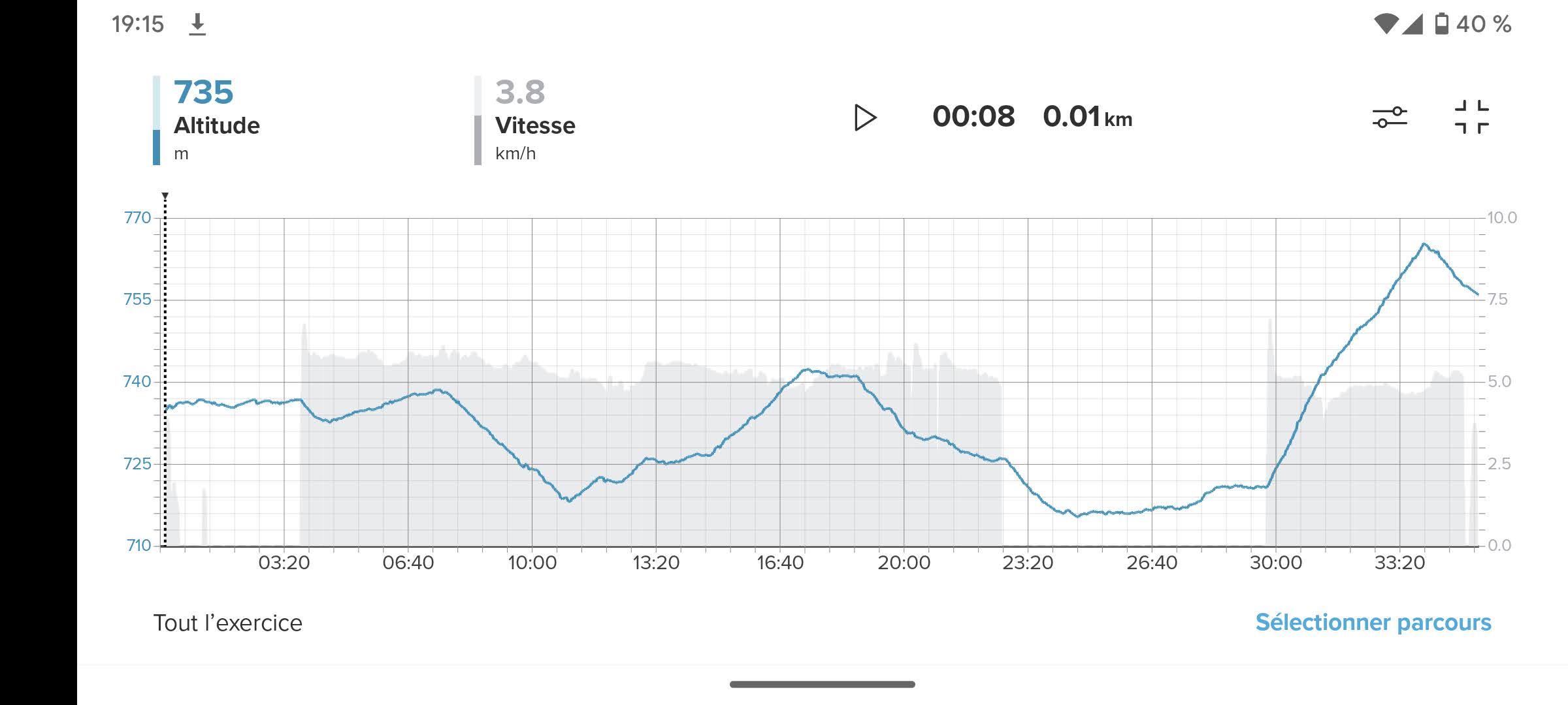
It’s even more obvious in this example. It’s a hike of 740 m of climbs, and Suunto gives me over 1200 m
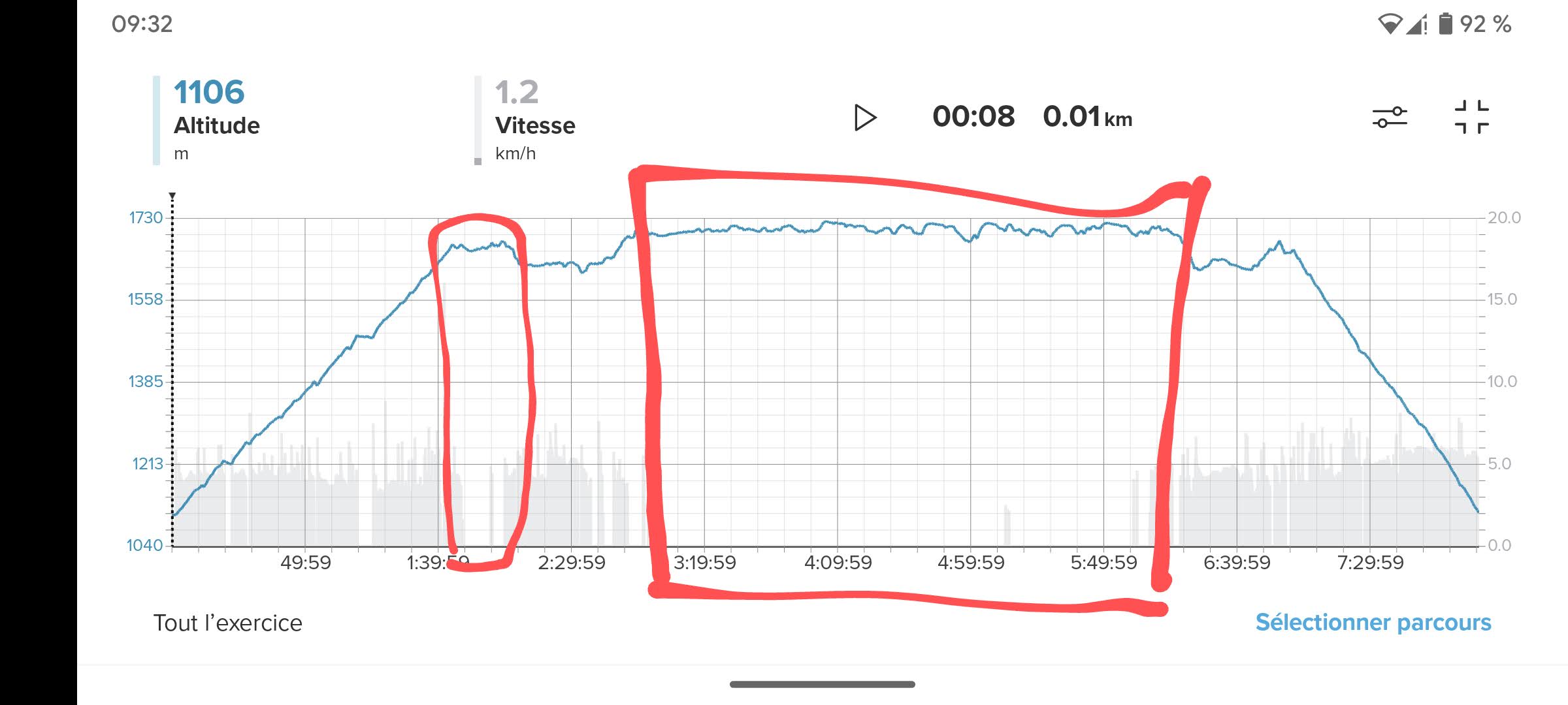
I will check with Suunto again to find a solution. Even having sent it for repair, I have to use my old 9 baro to get good data
-
@SteM64 I found this hike. 737 m according to Google maps, 750 with the 9 peak pro. The Race displays 1060m. It’s especially at a standstill that it does anything, what do you have on your altitude curve?
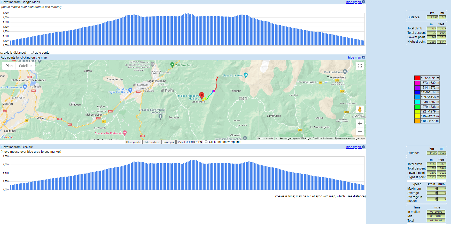
Youhou Suunto we need help and your after-sales service does nothing !!
-
@Clément-Lavabre said in Wrong total Ascent/Descent values in Hiking Sport Mode:
It’s especially at a standstill that it does anything, what do you have on your altitude curve?
sorry, I miss what you mean
-
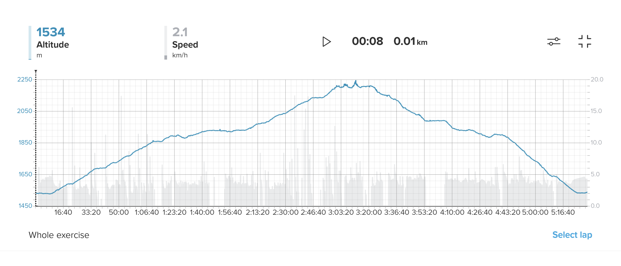
@SteM64 On the Suunto app, if you display the altitude curve and the speed curve, what does that look like? Does it make you feel like on my post above, permanent variations when stopped?
-
@Clément-Lavabre said in Wrong total Ascent/Descent values in Hiking Sport Mode:
Does it make you feel like on my post above, permanent variations when stopped?
ah! ok, no I don’t have that fluctuations, on the other hand I walked for most of the time, with just some short stops …
-
@SteM64
yes please. -
This weekend I made some other hikes in the same area, it was quite windy sometime but not as much as the week before. The total ascent/descent now agree well with the expected values, with just a 10-20m of difference, for all the hikes. I updated the firmware before the weekend, don’t know if this could have solved the issue, or if all the mess was just caused by the strong wind…
-
@SteM64 strong wind is one source of wrong ascent.
Please read Q6 for other possibilities (like your mentioned windproof jacket):
https://forum.suunto.com/topic/9960/more-faq -
 S Stefano M64 referenced this topic on
