Maps with no contours (can anyone from Germany, Finland on Spain confirm?)
-
@GiPFELKiND I doubt it, the new maps will be the default. Your only choice is to charge the watch sufficiently short times that the new maps cannot download. As I said before, yes this might be a bit of a problem short term but I do not use my maps at 1km or 2 km much while I am out running or skiing, they just are not that useful as there is insufficient detail. If I need the overview I use a map on the phone.
Vector/T6c/Vertical 2 Ti
-
@Brad_Olwin disabling “wireless network” in the watch settings should also ensure the maps don’t update to this new version without contours, right?
-
@Brad_Olwin said in Maps with no contours (can anyone from Germany, Finland on Spain confirm?):
@GiPFELKiND If I need the overview I use a map on the phone.
So why have maps on your watch if they will be useless and you will have to use your phone? So why buy and use such a watch at all?
In the mountains, contour lines are the most important navigation tools. And it is at the 500-2000m magnification that they are most needed.
I understand there are some technical problems (hopefully only temporary), but your words are completely absurd.
-
@maszop said in Maps with no contours (can anyone from Germany, Finland on Spain confirm?):
In the mountains, contour lines are the most important navigation tools. And it is at the 500-2000m magnification that they are most needed.
I understand there are some technical problems (hopefully only temporary), but your words are completely absurd.
Nothing more to comment
 hope for fast next map Update
 -
@maszop said in Maps with no contours (can anyone from Germany, Finland on Spain confirm?):
@Brad_Olwin said in Maps with no contours (can anyone from Germany, Finland on Spain confirm?):
@GiPFELKiND If I need the overview I use a map on the phone.
So why have maps on your watch if they will be useless and you will have to use your phone? So why buy and use such a watch at all?
I don’t know your use case, but to answer this question - here’s mine:
I am often out in the woods hiking or mountainbiking. Other use case is ski touring.
I usually plan my routes ahead and sync them to the watch. Now with watches that don’t show maps, it is often difficult to follow the route if there are trail forks. I have been walking or riding into the wrong branch quite often before. Now with maps I get the trail network and know where to go right away.
While ski touring, I don’t care for trails. The altitude profile lets me estimate the remaining ascent and also the profile itself, while the map tells me if I deviate from the planned route.I almost never feel the need to use the tiny watch screen like I use the map. This includes re-planning if I need to deviate from the plan and want to reach the summit on a different route. To get the bigger picture it would not work for me on the watch even with contour lines. I always have a printed map with me in the mountains (that I rarely pull out) and a phone as well, that I use sometimes as well…
In the mountains, contour lines are the most important navigation tools. And it is at the 500-2000m magnification that they are most needed.
While I fully agree to this in theory, it just not the way I personally use it. But anyway…
I understand there are some technical problems (hopefully only temporary), but your words are completely absurd.
Absurd maybe a bit harsh regarding the fact that other people have different use cases. I tried to explain mine.
Let’s wait for the higher zoom level contour lines to come back soon.Plus - again: The current situation is not the desired one. It was a tradeoff between having black tiles and grey parts of the maps in places, or the disadvantage of the contour lines at >=500m zoom. You might understand that a black tiled or grey map is far less usable than one with missing contours at high zoom levels.
-
@Egika
Maybe a bit harsh, but I guess it’s not surprising when someone writes that it’s such a strange decision to remove contours from the topographic map because everyone can check it on their phone anyway.
This decision itself is a great idea, but only for April Fool’s Day
I have never seen mountain topographic maps without contour lines in my life.
I will write again, in the mountains, contour lines are often the only thing visible on the map. Without these lines, the maps look the same as in the 9 Baro watch
The reactions are quite harsh, because this is not the first, seemingly obvious function that Suunto has (unfortunately forever) removed from outdoor watches.
I hope this gets fixed soon, otherwise these maps and Suunto watches in general will be useless in the mountains.
-
@maszop It is stated clearly that the current situation is a temporary one. So I think from here on we are going in circles now…
-
@maszop I and @Egika have both explained this situation. As far as we are concerned it does not make the maps useless in the mountains. I live in the mountains. Neither Egika nor I use the map on the watch much at the low zoom levels, 1km or 2km. These are our opinions not Suuntos and you are welcome to disagree. In fact, I would prefer the contour lines there as well but I would like to have some detail on the maps, names for example and trails at 500m is a great addition.
The forum is a place where we attempt to help, it is a forum of users and neither Egika nor I are employed by Suunto.
As stated before the change is temporary and is part of ongoing improvements in maps.
The reason they were removed is not because someone can use a phone. I hope after three responses this is clear for you. Perhaps you could use a tone in your responses that is less rude.Vector/T6c/Vertical 2 Ti
-
@maszop contour lines are important on topo map but if you got breadcrumb experiences, you should know you still can navigate without contour lines. so this map is still useful. contour lines is just a convenient tool for our navigation use.
-
@Brad_Olwin and @Egika Thank you all. I agree that the point has been made and let’s wait now. Each usecase is different. There was only one last thing that got lost in the discussion that I’d like to clarify. You both mention “>500m” and “1k and 2k” zoom levels. That would imply contours are visible at the 500m zoom. But from the annoucement I got the impression they are only at 200m and below. Not at 500m. Can you please let me know if they are at 500m zoom level or not?
Thank you. I honestly value your help here.
-
@Honza 500m in the updated maps currently have no contour lines.
I will edit my post to say >=500m -
@Honza No, the new addition to the maps are trails at 500m view, which were absent before. This is quite helpful. The contour lines will come back and hopefully more detail as well. I suspect map improvements will be ongoing and there may be temporary removal of certain features to rebuild additional ones. Maps are new for Suunto and I know that map responsiveness is a critical concern for them. From what I know Suunto is unwilling to reduce map responsiveness with too much detail.
I don’t know if you have ever tried to use a Garmin map on a Garmin watch while moving but for me it was nearly unusable.
-
@Brad_Olwin @Egika Thank you both. Honestly, respnsiveness is something I value a lot. As well as the paths at 500m zoom. That will be quite helpful once I’m willing to update
I have seen garmin only in videos or at home and looked good (but I still much prefer Suunto UI and aesthetics). I have also seen Coros Maps and those seemed really laggy, killing the experience.
So as I mentioned, I understand the direction and the need for this tradeoff. It’s frustrating for me, to be honest, that there was no better way, but it is what it is. For now, I have disabled wifi and will see how the situation develops. Excetied for the updates and hope they will come reasonably soon
Thanks again for the clarity
-
@Honza We are here to help and if you have a problem or a concern I do fieldtest for Suunto and I can forward those issues.
-
@Egika I just realized one thing as you described your usecase. Let me add that for more context, just fyi. No need to respond :). The main difference between us, I think, is the use of a predefined track. I use that only for long or complex outings where the navigation is tricky or when I move fast. In such cases, I actually use the watch in a very similar manner as you and would prefer paths over contours. But in my case, I don’t bother with making the track beforehand most of the time. I know where I’m going or I follow a simple path. In such cases, the watch provides the essential context of where I am, how far the summit is etc. Without the track, I don’t have the elevation profile and without the countours, I can’t use the map at those higher zoom levels to understand my position with regards to my planned route that’s in my head
-
@Honza thank you for sharing - and it totally makes sense to me!
-
@Honza I’m in the same use case than you.
But as French maps updates have been released, I want to see if the corrections I’ve made on OSM around my place are there now. [edit : my modifications are here !
 ]
]I still hope we will get contours again at 500m zoom level (or higher?)
But most of all I want the maps into my SV to remain as smooth as they are today.
-
Hi everyone, are these new features reported somewhere by Suunto? If they add the trail name to 500m, does Suunto write it down somewhere or do we have to check the forum? I don’t think it’s practical for users, many people may never find out about some features. We need at least a ‘log’ with all changes for every update, not only of the firmware, but also of the maps if there are substantial changes.
-
This locked https://forum.suunto.com/topic/9955/maps-update-rollout-december-2023/42 thread explains how contour lines are no longer available in zoom 500m+.
That was my expectation, so I was (very pleasantly) surprised to see that my SV actually shows contour lines even at 2km zoom level:
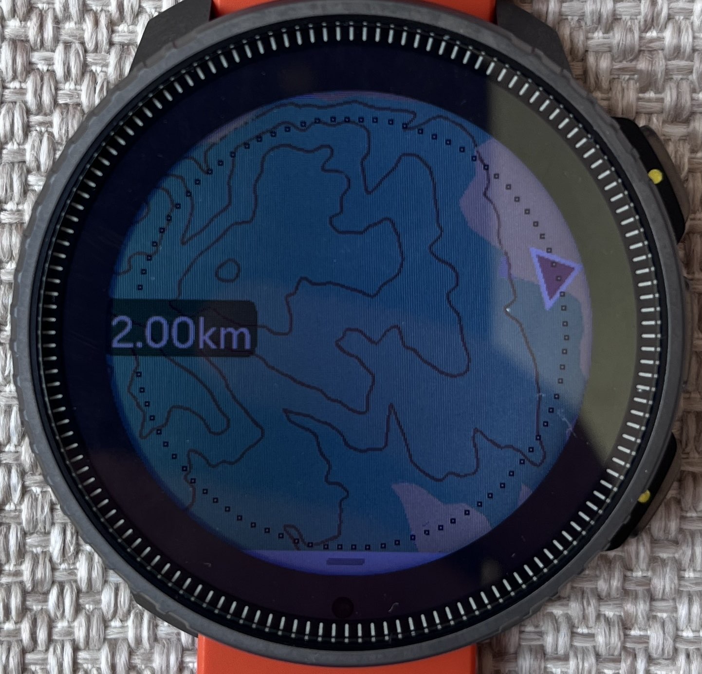
Was this fixed already?
 Or is something else going on?
 -
@slurpnik You simply have old maps from before the contour lines were removed.
Hello! It looks like you're interested in this conversation, but you don't have an account yet.
Getting fed up of having to scroll through the same posts each visit? When you register for an account, you'll always come back to exactly where you were before, and choose to be notified of new replies (either via email, or push notification). You'll also be able to save bookmarks and upvote posts to show your appreciation to other community members.
With your input, this post could be even better 💗
Register Login