NO GOOD DATA ASCENT (AND DESCENT)
-
@isazi I try to senso It. Hiking_2022-06-19T02_32_03.fit
-
@matteo-zambenedetti also, does it measure more or less than you expect?
-
@isazi much more. In this track the real ascent is about 1500 MT, 9 Baro says about 3000 MT…this morning, real about 500, 9 Baro about 650
-
@matteo-zambenedetti
and the graph doesn’t match the topographie of the recorded track if I’m not completely wrong. but it doesn’t exactly look like the sensor was covered.
did you calibrate the altitude manually just before the activity? -
@freeheeler yes, both times. Do I have to reset It?
-
@matteo-zambenedetti
no… next time: don’t touch it if alti is completely wrong, just start your activity. FusedAlti will calibrate it for you and will do it also throughout the activity when it compares to gps alti and detects it’s shifting
 -
@freeheeler OK I will do. A question: Does Fusedalti start automatically when I start my Activity?
-
@matteo-zambenedetti yes, during the first 15 minutes.
-
Good morning everyone,
I return to the subject to post some files to better explain my problem.
First of all, I don’t understand why SUUNTO does not provide software for pc but only apps for android (or mac) …
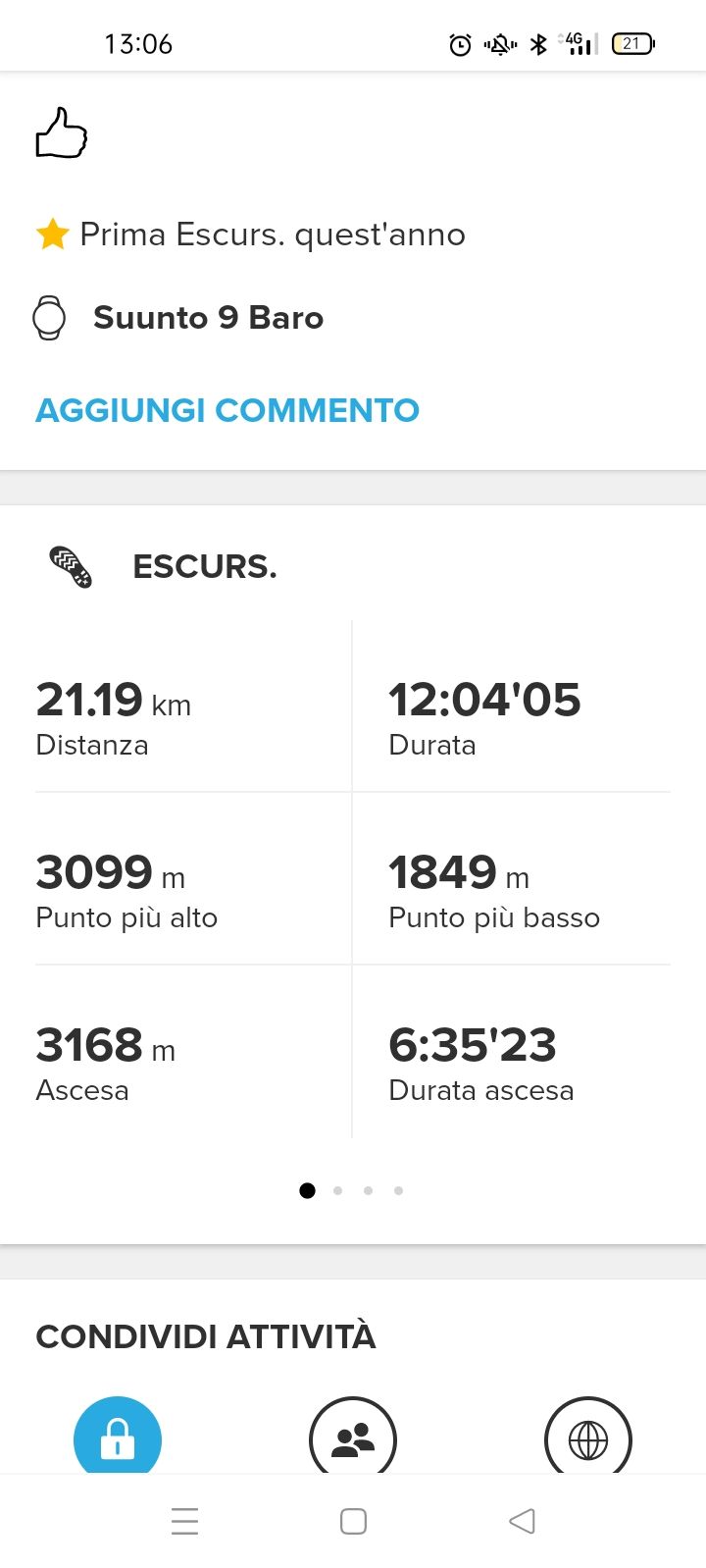
So, this is the screenshot of my hike according to the data of my 9 Baro and the app Suunto in my phone
ASCENT 3168MT!!! UNREALISTIC!!!
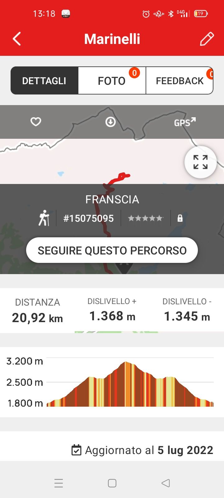
and this is the screenshot of the same track but downloaded on Openrunner software

ASCENT 1368MT!!! REALISTIC!!!
and this is the track.gpssuuntoapp-Hiking-2022-06-19T00-32-03Z-track.gpx
can anyone help me to understand and solve the problem?
what is the exact procedure to follow before starting a hike or a bike ride?I apologize if I can’t answer right away but I’m working and I don’t have much time
-
@matteo-zambenedetti what is the problem?
If you start higher than 1800m, and climb till 3200…at least roughly: 3200-1800=1400.
You have some other climbs on the graph, but also, you start higher than1800, so I can’t understand where is the issue. -
@matteo-zambenedetti Can you also share the ascent graph in the Suunto phone app?
-
the problem that openrunnere says I climbed 1368 meters (correct) while summarized says that I climbed 3168 meters (wrong)
-
the .gps track that posted before cannot be opened?
-
@matteo-zambenedetti I understand that the watch says the same than the Suunto app, am I right?
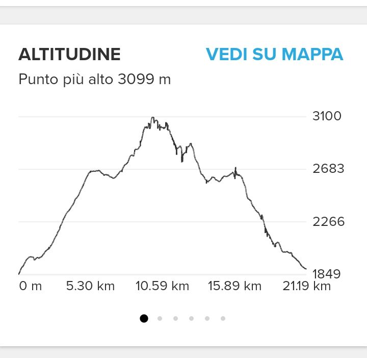
I want to see if the ascent graph from the watch has spikes, so it means that for some reason the baro sensor has been blocked (skin, jacket, wind,…) and for that reason you have higher ascent than expected.
-
@cosme-costa I understand what you mean. I therefore report the profile of my excursion: you will notice that there are no peaks.
However, if there were, Openrunner would have had to show me the same rise as Suunto. My problem is why was my 9 baro wrong?

-
@matteo-zambenedetti
because of several small spikes that I can already see without zooming in… maybe the other platform filters it by default? Strava filters by request -
@freeheeler Does your 9b the same?
-
@matteo-zambenedetti
yes, when the wrist strap is too tight and baro holes seal on wet skin, it catches wind gusts or wet garment is covering the baro holes…
check with your next activity and a bit looser wrist strap
-
@freeheeler Ok thanks, I will try this week-end.
-
@matteo-zambenedetti As @freeheeler says, you can see the small spikes that are adding ascent. The shape of the profile is quite correct as it is the min and max height, but during the activity it has been adding small ascent. And as it has been said probably because the baro sensor has been blocked.
I only have had this situation once and it was because it was raining and I was wearing the watch over my membrane jacket and the jacket blocked intermittently the baro sensor.
BTW, in which hand were you wearing the watch? Did you use poles? I ask this because this could increase the chances of blocking the sensor.