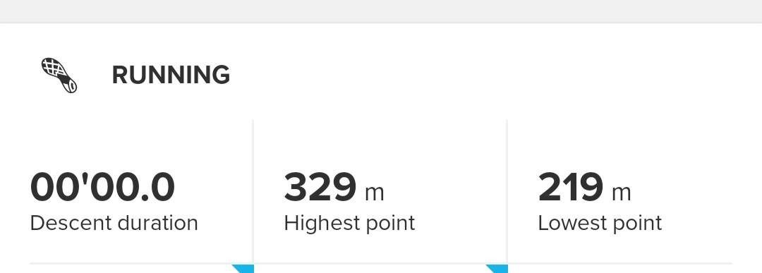
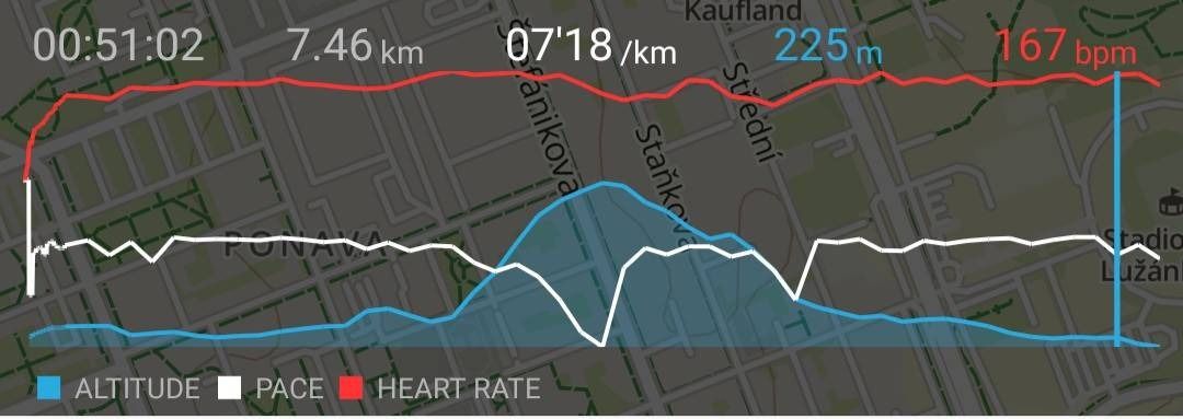
Elevation totally wrong
-
@arny14 aren’t you using other GPS modes than Performance (green)? S5 won’t show you ascent / descent if on Endurance (yellow). Also, when you’re using Endurance but have ETA/ETE on one of workout screens, watch will switch to Performance but software wise it’ll interpret the workout as if using Endurance.
-
@łukasz-szmigiel , thanks for your reply. For running, I am using the default ‘Running Basic’ exercise, which has ‘Battery mode’ set to Performance by default, which I never change manually. Unfortunately, I don’t know the color of the GPS arrow, but the GPX file, I am referring to, has a record every second, so I believe it proves that it was recorded in a Performance mode. Am I right?
For hiking, I am using the default ‘Trekking Basic’ exercise which has the Performance ‘Battery mode’ by default. Again, I never change it manually. But I will check the hiking GPX files to confirm that there is a record every second.And AFAIK, default ‘Running Basic’ and ‘Trekking Basic’ both don’t display ETA/ETE on any screens (turned on both now and don’t see ETA/ETE on any screen).
Edit: Hiking example. Suunto app: Ascent - 562m, Descent: 654m. GPX imported to mapy.cz: Ascent - 801m, Descent - 816m. Ascent error: 30%. Descent error: 20%.
Distance: 12,2km. Avg. speed: 2.2kmh (super heavy backpacks, multi-days trek…)Edit 2: Extreme example. Via ferrata. Sunnto app: Ascent - 395m, Descent - 729m. GPX imported to mapy.cz: Ascent - 861m, Descent - 819m. Ascent error: 55% (quite funny, ehm, not really…), Descent error: 11%.
-
But the most interesting part is, that the Suunto app displays the Lowest point 219m and the Highest point 329m (referring to my initial post), so it knows these data from GPX. And it even displays the altitude curve right. So it must be something strange in the algorithm how Suunto counts Ascent/Descent. Any information how it works would be appreciated.


-
@arny14 in S5 ascent / descent is calculated after you cross 14 m up/down (it’s for noise filtering as S5 doesn’t have a barometer). However, the only case where I’ve observed actual 1s fix with elevation data present but no ascent / descent is when the watch is set on different GPS mode than best, but the watch is using 1s fix regardless (i.e. ETA/ETE is present).
I don’t use default running or hiking profiles, so I’m not sure if ETA/ETE is present there. But you can easily test if it’s going to report ascent/descent with custom profile: Simply create a custom running profile and make sure there’s no ETA/ETE present. Prior to running, make sure you’re using Performance battery mode (green). During the run make sure you’re going to ascend at last 14 m.
-
As for the different ascent / descent reporting in SA vs mapy.cz - I suspect that mapy.cz calculates the values from the map itself and discards the GPX. It overlays the track on the map and takes data from there. And SA will show you ascent / descent calculated with 14 m filtering I’ve mentioned before, so rolling hills will be 0. Lowest and highest point should be roughly the same (+/- 30 m) but overall ascent / descent might differ a lot.
-
@łukasz-szmigiel, thanks for pointing to the “noise filtering” feature. Yesterday, I’ve created a custom running mode, just to be sure, without ETA/ETE. Suunto lowest point 215m, highest point 325m, running from the same point to the same point. Suunto ascent 85m, descent 92m. Mapy.cz Ascent/Descent 110m. If Suunto used the most primitive method, subtract the lowest point from the highest, it would get the exact ascent/descent value of 110m. Instead it uses “advanced” feature like noise filtering, which causes exactly the opposite -> 23% ascent error, 17% descent error (which is anyway still better than 30-50% error when hiking or on via-ferrata).
In my opinion, it would make sense to use the “noise filtering” feature only when there is a weak GPS signal and Suunto does definitely know the signal strength.But the most important question and then we can close this thread. What can I do to make the ascent/descent more precise, except from buying a new watches with baro?
-
@arny14 the signal should definitely be worse when doing a via ferrata, since you’re so close to a rock wall.
Additionally, I suspect that the movement speed plays a crucial role in terms of altitude gain accuracy. Meaning, the watch suspects small and slow altitude changes as noise and filters them out. Since via ferrata is probably way slower than hiking up the mountain, I’d suspect it can be one of the contributing factors to the bad date afterwards.
In any case, I prefer to edit elevation after the activity by double checking with the map. Hopefully, someday autocorrection will be implemented into suunto app to ease the process. -
@arny14 there’s not much you can do right now, I’m afraid. The filtering is built into firmware (although I agree that the algo could be dynamic as the information about VDOP is there, every second). So far only S9P offers 1 m ascent / descent calculation (even S9B is limited to 3 m as far as I know).
I can only recommend testing GLONASS and Galileo and waiting a little longer (~ 30 seconds) before hitting the start for GPS to normalize (especially to avoid absurd drops in height during the start).
-
Maybe the algorithm will improve soon enough… Anyway a baroless device will always (unless gnss technology improves a lot) have issues in hilly terrain, while doing well enough with long climbs.
And if Suunto removed the filter, you would climb hundreds of meters on totally flat terrain. I’ve tested that

-
@dmytro, I can support that the movement speed plays an important role. When running fast, the ascent/descent error is about 20%, when walking slowly it’s 30-40%, on via ferrata 55%. Thanks for an advice for editing the activity manually, I forgot that I can do it manually in the app.
@łukasz-szmigiel, thanks, I will be playing with Glonass vs Galileo vs Beidou, but the information about the elevation information is in the GPX itself, Suunto just “filters” it out.
@isazi, if this is the best the Suunto can get from GPS altitude data regarding the ascent/descent, I am quite disappointed, as I suppose any random cheap gps+baro watches will be getting much more accurate measurements. The filtering should be used in a more fine way. In a situation described by you, it helps. In my situations, it makes the data less accurate.
-
I bought Suunto 5 Peak a few weeks ago. I previously had Suunto 3 and one on my motives to buy a new watch was to be able to see the ascent / descent information on the exercises.
Using Suunto 3 this data was not available. I was not very happy because I bought the watch, gained some features but also lost feature that I had using only cellphone. I had contacted Suunto about this as the data is available using only cellphone without sports watch on Sports Tracker also. Their explanation was that Suunto 3 with bluetooth + cellphone GPS is not accurate enough to have this feature.
Using Suunto 5 the elevation data is completely useless. The app shows even negative elevations and over hundred meters of difference in ascent/descent on an hour or two of running/cycling with same start and stop point. Seems I bought the new watch for no gain. I’m even less happy now.
-
@Hekemon The 5 Peak uses GPS for altitude and will not be as accurate as a watch with a barometric sensor. Can you show or link to some of the examples that are a problem?