Elevation without baro but with track navigation
-
@Egika would it make any sense to use track data when available? I wonder if it’s possible with current hardware. It could be useful for trail running or general outdoor exploration when following track. Of course with certain, sane threshold.
-
@Łukasz-Szmigiel I was thinking about this after typing my response - because I like the idea!
Cons:
- In other threads we just found, that the DEM is of questionable quality on some regions…
- would not work for something like paragliding, where you are on track just at a different height (ok, this is not the home of S5 anyway…)
- difficult to handle situation if you leave the route. You can’t store the whole surrounding, so have to stay on the path. If you leave it there could be jumps in the data…
So it comes down to the questions if that data would be of higher spatial resolution than the GPS with low pass filter delivers…
-
Data wise this could also be a very complicated. Meaning it should work like the S7 predownloading an area.
-
Yeah, it’s challenging to implement and to do it right.
I think it could be done if S5/S9 (non-baro) OS can read elevation from track data. It shouldn’t require any extra data apart from XYZ coordinates.
As for cons that @Egika specified:
- I don’t know about the elevation data quality but generally GPX are being sent through SA anyway so the data could always be normalized to OSM. This can be ok if the elevation data provided by OSM is of good quality everywhere (which I assume isn’t). Perhaps there can be a flag in GPX which is sent to watch that stored elevation quality is good enough to use it for elevation.
- It wouldn’t work for paragliding and many other sport types but it’s easy to filter through in-watch sport types. Just enable it for some and disable for others.
- In order for it to be useful it would require some sort of threshold and smoothing so it could activate / deactivate dynamically when going off-path. It shouldn’t be a problem with poor GPS reception and poor VDOP as the main idea about this implementation is to counter the effect of poor VDOP - the watch should prefer elevation data from track instead of GPS if VDOP is poor.
- It could also be a user-preference in watch in activity preparation screen (the same way OHR on/off works). Just tell users what are pros and cons and let them decide.
@Dimitrios-Kanellopoulos what you’re proposing is more like creating a 2D mesh of points (predownloaded) in case the user goes off-path but I don’t think it’s necessary as it could work dynamically (GPS based when off-path and track-based when on path with some sane threshold to filter out absurd readings).
-
Would be great but as @Egika mentioned the altitude data isn’t always correct in a region as I recently found out: https://forum.suunto.com/topic/5234/route-altitude-bug?_=1601934285515
-
@surfboomerang shame. It would be a great addition for gps only watches.
-
Hi all, sorry to revive this topic back to live.
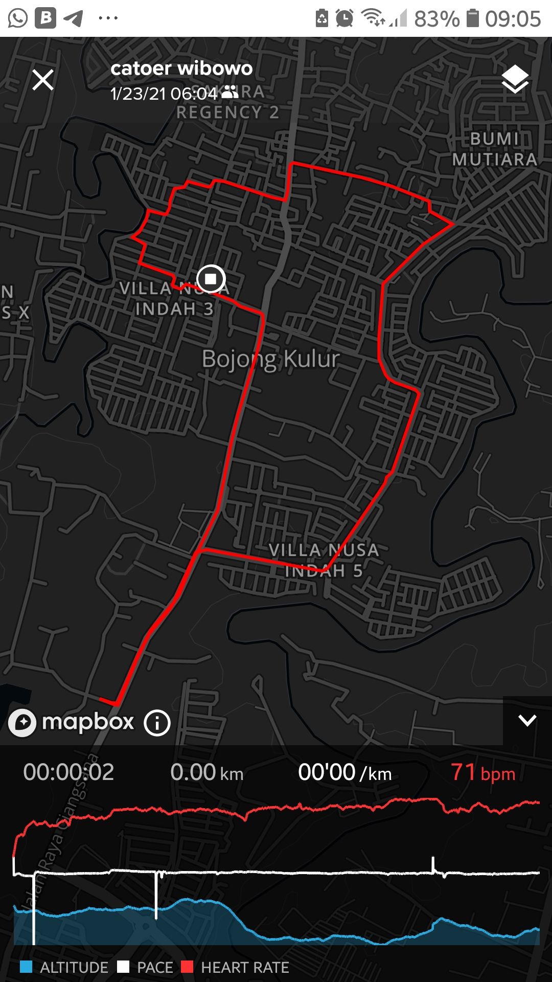
by the way, I just give myself an S5 as a present. But since it does not have any barometer, the GPS reading of the elevation can’t be considered good especially at start point. I observed this when I do a loop (run or bike) by starting and finishing at the same point. the elevation of the finish point is much lower than the starting point despite it is the same spot or at least same area. When the activity is transferred to strava, it shows better elevation, but when you see it in the suunto app the start point always shows much higher elevation. this always happens in the past runs/bikes and i tried to lock the GPS as long as possible (circa 2 minutes) before I press start of the activity. But it did not make any change. Anything I can do to improve the situation? (pictures attached). Thank you all. Stay safe and healthy.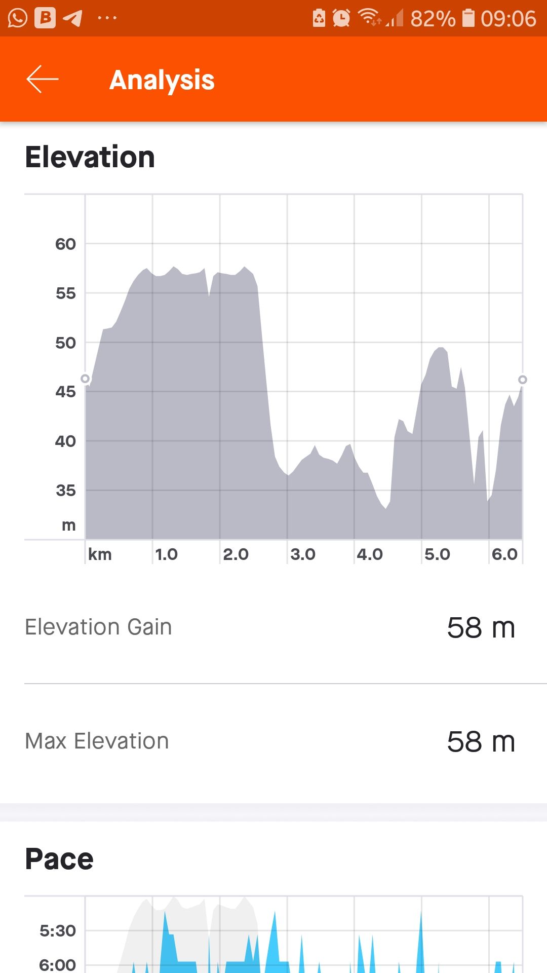
Suunto Spartan Trainer Wrist HR (traded in with S5)
Suunto 5 -
@catoer-wibowo
Strava uses known altitude maps to correct your data. So it is normal that same point will have same altitude.
Watch uses only GPS and at start and end measurement, precision of GPS, even at same point may give other value.
If difference is less than 20/30m, I think you can’t do more.
What is start/end difference in SuuntoApp altitude?SSU (retired), SV1, SV2
Wife : S9PP
SA: Always the latest beta :)
Android + Galaxy S205G -
@catoer-wibowo you can always try using second GNSS, like Beidou which can (but doesn’t have to) improve vertical accuracy.
However with GPS based elevation, 30m error is pretty much normal.
S9PP 2.50.28
-
@mff73 said in Elevation without baro but with track navigation:
@catoer-wibowo
Strava uses known altitude maps to correct your data. So it is normal that same point will have same altitude.
Watch uses only GPS and at start and end measurement, precision of GPS, even at same point may give other value.
If difference is less than 20/30m, I think you can’t do more.
What is start/end difference in SuuntoApp altitude?hi @Mff73 the difference is around 15 meters. So this is fine then. I dont have to do anything. But I will try to sync my watch before activities outdoor. Hoping the difference can be less than 15 m. thank you…
-
@łukasz-szmigiel said in Elevation without baro but with track navigation:
@catoer-wibowo you can always try using second GNSS, like Beidou which can (but doesn’t have to) improve vertical accuracy.
However with GPS based elevation, 30m error is pretty much normal.
yes, I did use other GNSS. the basic is GPS and QZSS and currently I add Galileo because reading from some articles Galileo gives better accuracy compared to Glonass or Beidou. But it may work better in Europe ya? I dont know. Maybe I will just try the same track with different GNSS combination to see which one is closest to Strava. anyway thanks a lot for the inputs. I dont have to worry now…
")