S9 Baro Pre-purchase questions - navigation and displayed data
-
Hello good folks,
I’m going to buy a watch and I’m hesitating between the S9 Baro and Garmin, what pulls me towards the S9 is FusedAlti because I really care about an accurate altimeter.
How will I use the watch - I do not care about daily tracking (I will not wear it on a daily basis), I do not run. I want to take it for trekking / climbing for 5-7 days, sometimes longer.
The most important things I expect are accurate route tracking, altitude profile and navigation (but navigation not to follow the route, but to display the remaining distance, ETA/ETE and how much ascent/descent is left).
I did my homework and read the manual carefully on the Suunto website and watched various reviews and so far I know that I should use AP without MC. I downloaded the application, I did the test, it is possible to upload the route both via sportstracker (automatic synchronization) and gpx file, all ok so I will not ask about it.
So after this introduction and outlining expectations, I have the following questions for you if you do not mind:- Can navigation along a predetermined route be started at any time while recording activity (according to the instructions yes) and the watch will recognize that I have already walked part of the route and recalculate the altitude profile, ETA/ETE and the remaining distance?
- Are the above-mentioned data displayed during the activity (I saw a screenshot with the altitude profile in the manual, it looked great, but I did not see the remaining distance and ETA/ETE)?
- Can the watch be synchronized with the application if the phone does not have internet access?
- How much memory does the watch have, or rather how many activities can be registered before it runs out of space?
Thank you very much for your answers and help with the purchase.
-
s9 is a great watch for your requeriments
1-. YES
2-. YES
3-. YES
4-. maybe @Dimitrios-Kanellopoulos knows -
Memory wise:
15 routes max each route simplified to 1000points
Storage is on hours and depends on the data frequency.
That means and ensures: 40h on 1s recording at leastCommunity Manager / Admin @Suunto
Creator of quantified-self.io - sync Garmin and COROS activities to Suunto, import Suunto routes, deliver Suunto routes to Garmin courses, and analyze training data in one private dashboard. -
@jorgefd78 thank you very much Sir
")
@Dimitrios-Kanellopoulos I must say these are rather low values…
Can I keep any number of saved routes in SA and, if desired, upload / delete them from the watch at any time?
Will synchronizing the watch with SA (when the phone is offline) remove activity from the watch memory and free up memory space? I often go trekking for about 12-14 hours a day for several days in a row and that would mean that I would not have enough space before the end of the trip … -
@kabzior
I currently still have in my SSU logbook (not S9 though, but i can’t imagine SSU have more memory) :
55 workouts
91h of recording with HR + GPS at bestAnd yes, you can sync your watch offline when you want after each activity.
then the memory will not be freed but old activities will be “erased” to let new ones when needed. -
Thank you very much guys, it probably dispels all my doubts before buying (maybe except for the software, because wherever I ask about Suunto, a lot of people keep saying that hardware is rock solid, but complaining that something is constantly not working for them, but I will have to find out for myself
") )
) -
You can toggle the routes no problem being offline.
However you cannot create new routes. That needs internet afaik. But. You can import a gpx on offline mode (just tested and made sure). If another app can work offline and create a gpx based eg in predownloaded topo etc maps that should work. I think gaia gps does this. I might be wrong but I am confident (have not used it the last 6 months referring to gaia)
So for example you can use the app as a depot for 300 routes and choose which 15 you carry on the watch.
Personal remark.
I typically select to have about 5 on the watch so it doesn’t get crowded.
Community Manager / Admin @Suunto
Creator of quantified-self.io - sync Garmin and COROS activities to Suunto, import Suunto routes, deliver Suunto routes to Garmin courses, and analyze training data in one private dashboard. -
@Dimitrios-Kanellopoulos said in S9 Baro Pre-purchase questions - navigation and displayed data:
If another app can work offline and create a gpx based eg in predownloaded topo etc maps that should work. I think gaia gps does this
Locus maps can do it with Brouter integrated.
-
@DavorP
It works great -
@Dimitrios-Kanellopoulos How many hours-worth of storage on the other data freq settings, please? Hiking for 5-7 days, the OP might not need/prefer 1s recording. (And I wouldn’t mind knowing.) Is there a convenient table for the various recording settings?
-
@Dimitrios-Kanellopoulos said in S9 Baro Pre-purchase questions - navigation and displayed data:
However you cannot create new routes. That needs internet afaik. But. You can import a gpx on offline mode (just tested and made sure). If another app can work offline and create a gpx based eg in predownloaded topo etc maps that should work. I think gaia gps does this. I might be wrong but I am confident (have not used it the last 6 months referring to gaia)
OK, I get it, thanks for that, it makes sense since SA does not have offline maps.
However I mainly use site called mapy.cz/en for creating routes (there is an outdoor version of map), I find it to be extremely accurate in terms of even the smallest pathways deep in the woods (at least in Europe). They offer phone app with offline maps and gpx export, and everything is 100% free. So I already tested that creating a route offline and exporting it as gpx file to SA works like a charm, at least on iPhone (that is why I do not use Locus).
I must say this is a huge advantage over Garmin as I was said that Connect App will not work at all when phone is off the Internet.Anyways, just pulled the trigger on Suunto 9 Baro White, so I guess you will be seeing me here in the future, praising or complaining, time will tell
@Fenr1r said in S9 Baro Pre-purchase questions - navigation and displayed data:
How many hours-worth of storage on the other data freq settings, please? Hiking for 5-7 days, the OP might not need/prefer 1s recording. (And I wouldn’t mind knowing.
I prefer 1s since all I care about is accurate tracking and altitude, but I also wouldn’t mind knowing, just out of curiosity (and maybe I will turn off HR to save some space if it makes a difference).
-
@Fenr1r said in S9 Baro Pre-purchase questions - navigation and displayed data:
Hiking for 5-7 days
I doubt about the storage on 1s if you record 7*18=126h. Here is the deal if I am correct.
When you use the ultra (or any non-1s gps based mode) I think it still records at 1s things like HR , Altitude and other internal stuff (abs pressure etc). Then depending also if you use a RR (Belt = more storage needed) etc can easily max out the capacity.
Perhaps a suggestion, is to sync offline with the app 1nce per 2 days and go “worries free”
Unfortunately I have not the ability to know the exact numbers, and I am asking this for you
Community Manager / Admin @Suunto
Creator of quantified-self.io - sync Garmin and COROS activities to Suunto, import Suunto routes, deliver Suunto routes to Garmin courses, and analyze training data in one private dashboard. -
@Dimitrios-Kanellopoulos said in S9 Baro Pre-purchase questions - navigation and displayed data:
Unfortunately I have not the ability to know the exact numbers, and I am asking this for you
Thanks. The OP seems happy with the answer on 1s and that’s the important bit. As for my curiosity, should we try to get @Brad_Olwin to ask? He seems to have the magic touch in obtaining storage vs settings stats.
-
@kabzior said in S9 Baro Pre-purchase questions - navigation and displayed data:
- Can navigation along a predetermined route be started at any time while recording activity (according to the instructions yes) and the watch will recognize that I have already walked part of the route and recalculate the altitude profile, ETA/ETE and the remaining distance?
- Are the above-mentioned data displayed during the activity (I saw a screenshot with the altitude profile in the manual, it looked great, but I did not see the remaining distance and ETA/ETE)?
- Can the watch be synchronized with the application if the phone does not have internet access?
- How much memory does the watch have, or rather how many activities can be registered before it runs out of space?
1 Yes. You can change routes as you go and you can even create a route on the app and sync it to the watch while recording an activity.
Altitude, ETA and ETE (I use them a lot), provided your pace is constant, are very accurate and reliable to calculate exactly when you’ll reach a mountain hut or some other waypoints along the way.
2 Yes. You can display 7 fields of data (plus the real time) in each watchface, and how many watchfaces you want. If you hike or trek even the 7 fields watchface is big enough to be readable.
3 Yes, but some functions are limited.I use my S9 Baro mainly for trekking, hiking and alpinism.
After hundreds of activities completed I can tell you that my main pro for the S9 is reliability. My watch has endured temperatures ranging from -30 degrees celsius to 45 degrees celsius, has been used in rainy and snowy days and never failed or turned off. -
@General_Witt said in S9 Baro Pre-purchase questions - navigation and displayed data:
I use my S9 Baro mainly for trekking, hiking and alpinism.
After hundreds of activities completed I can tell you that my main pro for the S9 is reliability. My watch has endured temperatures ranging from -30 degrees celsius to 45 degrees celsius, has been used in rainy and snowy days and never failed or turned off.Thank you very much for sharing, this is exactly the same scenario in which I am going to use the device, therefore your opinion is extremely valuable to me.
By the way, a few additional questions if you don’t mind:- I see in the manual that “Sport modes have their own alti-baro profile setting. You can change this setting in our online account. The options are automatic, barometer only, or altimeter only.” Which option would you recommend for mountaineering?
- How does FusedAlti perform in cold winter in high mountains? Under a jacket, under gloves, does this affect the barometer readings?
I am already preparing the routes, waiting for the purchased S9B to arrive and I noticed that after creating the route in SA it can no longer be edited, it’s a pity. Especially that I didn’t add any waypoints on the routes, only start -> end. And now I wonder whether to create them from scratch with points added, because you mentioned this:
Altitude, ETA and ETE (I use them a lot), provided your pace is constant, are very accurate and reliable to calculate exactly when you’ll reach a mountain hut or some other waypoints along the way.
so, I am thinking - is it possible to display on the navigation simultaneously (not necessarily on the same screen) ETA/ETE/distance to the next waypoint and to the end of the route simultaneously? Because I think it would be nice to know when I’ll get to the mountain hut for tea, but not at the expense of information how much until the end of the route
Anyway, your experiences and what you wrote confirm that I made the right choice, thank you once again.
-
@kabzior said in S9 Baro Pre-purchase questions - navigation and displayed data:
I see in the manual that “Sport modes have their own alti-baro profile setting. You can change this setting in our online account. The options are automatic, barometer only, or altimeter only.” Which option would you recommend for mountaineering?
This is automaGically managed by the watch now. This option was available when Movescount was used
Someone miss it, someone doesn’t.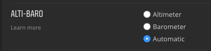
How does FusedAlti perform in cold winter in high mountains? Under a jacket, under gloves, does this affect the barometer readings?
Usually it works well, but of course, as the sensor is “insulated” it could be a bit off sometimes, depending on how you wear the watch (sensor holes closed). There is a topic about this , search for it
so, I am thinking - is it possible to display on the navigation simultaneously (not necessarily on the same screen) ETA/ETE/distance to the next waypoint and to the end of the route simultaneously?
Yes it is. You have several “distance” fields you can add to the screen
I have a screen with ETA / ETA next WP / time / sunset time … really useful on log hikes or when the sh*t starts hitting the fan
-
@sartoric said in S9 Baro Pre-purchase questions - navigation and displayed data:
Usually it works well, but of course, as the sensor is “insulated” it could be a bit off sometimes, depending on how you wear the watch (sensor holes closed). There is a topic about this , search for it
I will, thank you. To be honest last few days has been like doing nothing else than reading this forum
And does the temperature affect battery life significantly? Since I do not care so much about HR (in opposite to alti) maybe it would be better to wear it on jacket. On the other hand winds in winter are quite strong and this also affects alti as I read here on forum, I guess I will have to check it myself.Yes it is. You have several “distance” fields you can add to the screen
I have a screen with ETA / ETA next WP / time / sunset time … really useful on log hikes or when the sh*t starts hitting the fanWOW, damn, this gear is getting better and better every day… And they haven’t even sent the watch yet
It’s like a hikers dream come true - you get functions that are absolutely essential, even though you didn’t even know they existed in the first place
ps - and to think I was so close to buying the Garmin Instinct …
-
@kabzior said in S9 Baro Pre-purchase questions - navigation and displayed data:
- I see in the manual that “Sport modes have their own alti-baro profile setting. You can change this setting in our online account. The options are automatic, barometer only, or altimeter only.” Which option would you recommend for mountaineering?
- How does FusedAlti perform in cold winter in high mountains? Under a jacket, under gloves, does this affect the barometer readings?
1 It’s all automatic and “invisible” now.
2 I always wear the watch under a pair of thick jackets during winter (e.g while skiing) and almost never had any issue with the GPS and the barometer.
This watch had terrible altitude inaccuracies when launched, but firmware after firmware it is now very accurate.
I haven’t noticed any battery duration reductions in cold weathers.And now I wonder whether to create them from scratch with points added, because you mentioned this
It depends on the route. I use waypoints a lot to highlight a cave, shelter of any type, drinkable water and other useful locations during my activities.
is it possible to display on the navigation simultaneously (not necessarily on the same screen) ETA/ETE/distance to the next waypoint and to the end of the route simultaneously?
It is possible and I show them in the same watchface to get all the “time” informations I need in the same place.
I’ll show you a photo of what I use during mountaneering and hiking.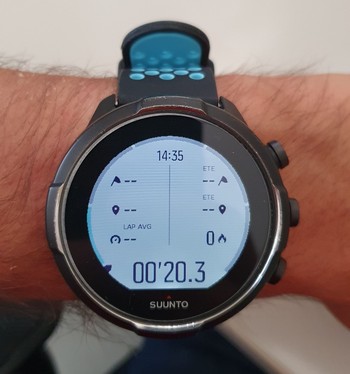
-
@kabzior said in S9 Baro Pre-purchase questions - navigation and displayed data:
ps - and to think I was so close to buying the Garmin Instinct …
Garmin Fenix has some pros like the pulse oximeter, that you don’t really need for mountains lower than 5K meters, and colored maps on the watch, useful when you want to deviate your original route for a new path and you don’t want to put your phone out to read the map. Both not a deal breaker, at least for me.
The Garmin software on the other hand, while better than Suunto because is richer and has way more infos at your disposal, it’s also extremely confusing and somewhat clunky to use. -
@General_Witt said in S9 Baro Pre-purchase questions - navigation and displayed data:
This watch had terrible altitude inaccuracies when launched, but firmware after firmware it is now very accurate.
So it is true that one should by a hiking watch no sooner than one year after it is released…
I’ll show you a photo of what I use during mountaneering and hiking.
WOW, that is outstanding! This will be really useful for me, thanks.
And if you have more points on your track, the watch shows the time/distance to the closest one, and then after reaching it, it switches to the next point?
It is a really PITA that one can not import a route with points in it or edit the route that is already in SA
Garmin Fenix has some pros like the pulse oximeter, that you don’t really need for mountains lower than 5K meters, and colored maps on the watch, useful when you want to deviate your original route for a new path and you don’t want to put your phone out to read the map. Both not a deal breaker, at least for me.
I considered Fenix at the beginning, but firstly I already have a house mortgage
(and I managed to buy S9B for 1/3 of the Fenix’s price), secondly, I always, absolutely always have a paper map with me, and additionally a phone with an offilne map, so I really don’t need the maps on my watch. I wanted the altitude profile and the remaining distance, hence the decision to buy Garmin Instinct and not Fenix. But Instinct has a lot of problems with the altimeter (and bad barometer placement), and Suunto has that FusedAlti that blows out of the water other watches (like DC Rainmaker’s review, he took S9B to Stelvio pass which is 2760m and log showed recorded elevation… 2760,1m… jawdrop).At first everyone advised me against Suunto - something still is not working, software problems, general mess … In many reviews too, poor application, not everything is as obvious and simple as with Garmin etc. So I was looking for Garmin. But when I saw this FusedAlti I started to take a closer look. I read the forum, downloaded SA even though I didn’t have a watch, I checked how it would suit my needs. And it turned out that what I wanted works great. Maybe not as natively and immediately as with Garmin (I create a route in Komoot, it syncs with the Connect app and the web version and that’s it), but the gpx import works without any problems (both from komoot and from mapy.cz), creating a route in the application is much better in SA than in Connect, and on the computer for years now I watch everything on Strava anyways (plus I discovered SQ just now). So by putting in a little effort, I got what I think is a much better product that meets my expectations.
Hello! It looks like you're interested in this conversation, but you don't have an account yet.
Getting fed up of having to scroll through the same posts each visit? When you register for an account, you'll always come back to exactly where you were before, and choose to be notified of new replies (either via email, or push notification). You'll also be able to save bookmarks and upvote posts to show your appreciation to other community members.
With your input, this post could be even better 💗
Register Login