Suunto app Forum Suunto Community Forum
    • Recent
    • Tags
    • Popular
    • Users
    • Groups
    • Register
    • Login

    Doubt about Suunto 9 Baro altimeter/barometer calibration

    Scheduled Pinned Locked Moved Suunto app and other software services
    104 Posts 14 Posters 22.7k Views 17 Watching
    Loading More Posts
    • Oldest to Newest
    • Newest to Oldest
    • Most Votes
    Reply
    • Reply as topic
    Log in to reply
    This topic has been deleted. Only users with topic management privileges can see it.
    • J Offline
      johann.fuehrer Bronze Member @freeheeler
      last edited by johann.fuehrer

      @TELE-HO Is it possible for you to merge this one and the recorded one in to one graph? Maybe quantified.io is helpful? I did nor use it yet, but have seen a lot of such stuff is done in there by others…

      Dimitrios KanellopoulosD 1 Reply Last reply Reply Quote 0
      • Dimitrios KanellopoulosD Offline
        Dimitrios Kanellopoulos Community Manager @johann.fuehrer
        last edited by

        @johann-fuehrer Jup that is possible

        Community Manager / Admin @Suunto
        Creator of quantified-self.io - sync Garmin and COROS activities to Suunto, import Suunto routes, deliver Suunto routes to Garmin courses, and analyze training data in one private dashboard.

        1 Reply Last reply Reply Quote 0
        • freeheelerF Offline
          freeheeler @mario_b
          last edited by

          @mario_b
          yes I am aware that you switch off fused alti when manual calibrating during an activity recording.
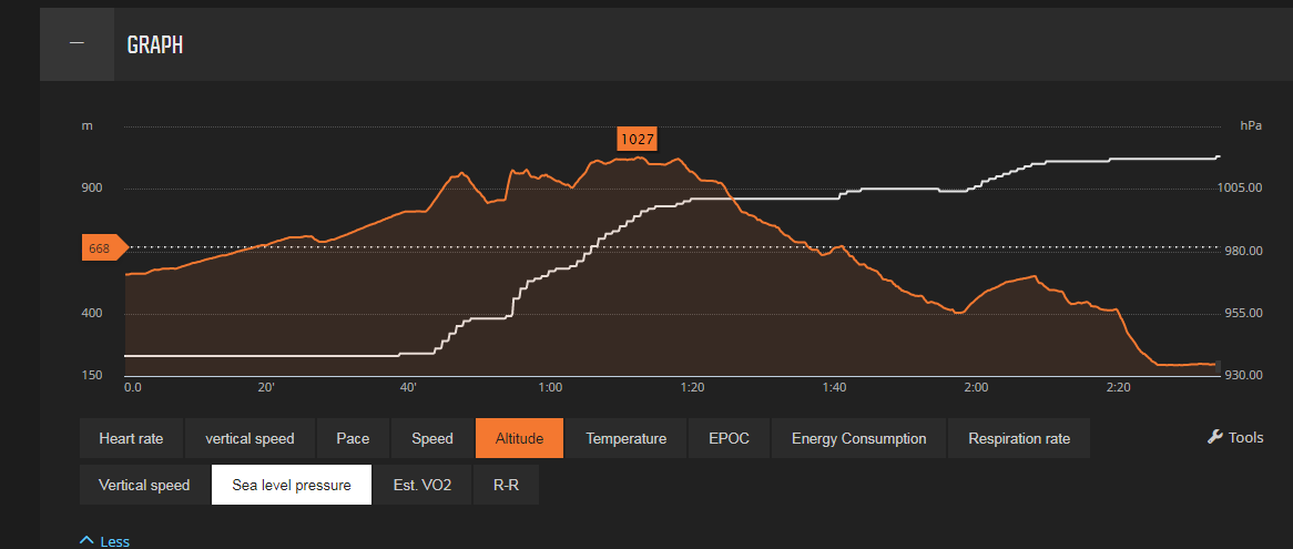
          Here’s the sea level pressure with the altitude profile.

          @Dimitrios-Kanellopoulos
          I don’t know who to do an overlay… but if I do an overlay, it would be necessary to have it almost idential from the drawn to the recorded track to have the best comparison, right?
          6414a92e-187c-478b-9d3c-00e2324642f5-image.png

          living sideways

          Dimitrios KanellopoulosD J mario_bM 3 Replies Last reply Reply Quote 0
          • Dimitrios KanellopoulosD Offline
            Dimitrios Kanellopoulos Community Manager @freeheeler
            last edited by

            @TELE-HO update 2 activiteis / routes to QS.
            Select them on the table
            Press merge
            Use the distance axis when viewing

            Community Manager / Admin @Suunto
            Creator of quantified-self.io - sync Garmin and COROS activities to Suunto, import Suunto routes, deliver Suunto routes to Garmin courses, and analyze training data in one private dashboard.

            1 Reply Last reply Reply Quote 0
            • J Offline
              johann.fuehrer Bronze Member @freeheeler
              last edited by

              @TELE-HO for a GPX track you can get “real” altitude information here i.e. https://www.gpsvisualizer.com/elevation but I do not know how exact that is…

              J 1 Reply Last reply Reply Quote 0
              • J Offline
                johann.fuehrer Bronze Member @johann.fuehrer
                last edited by

                @johann-fuehrer … it’s a 30m x 30m grid SRTM1

                1 Reply Last reply Reply Quote 0
                • Dimitrios KanellopoulosD Offline
                  Dimitrios Kanellopoulos Community Manager
                  last edited by

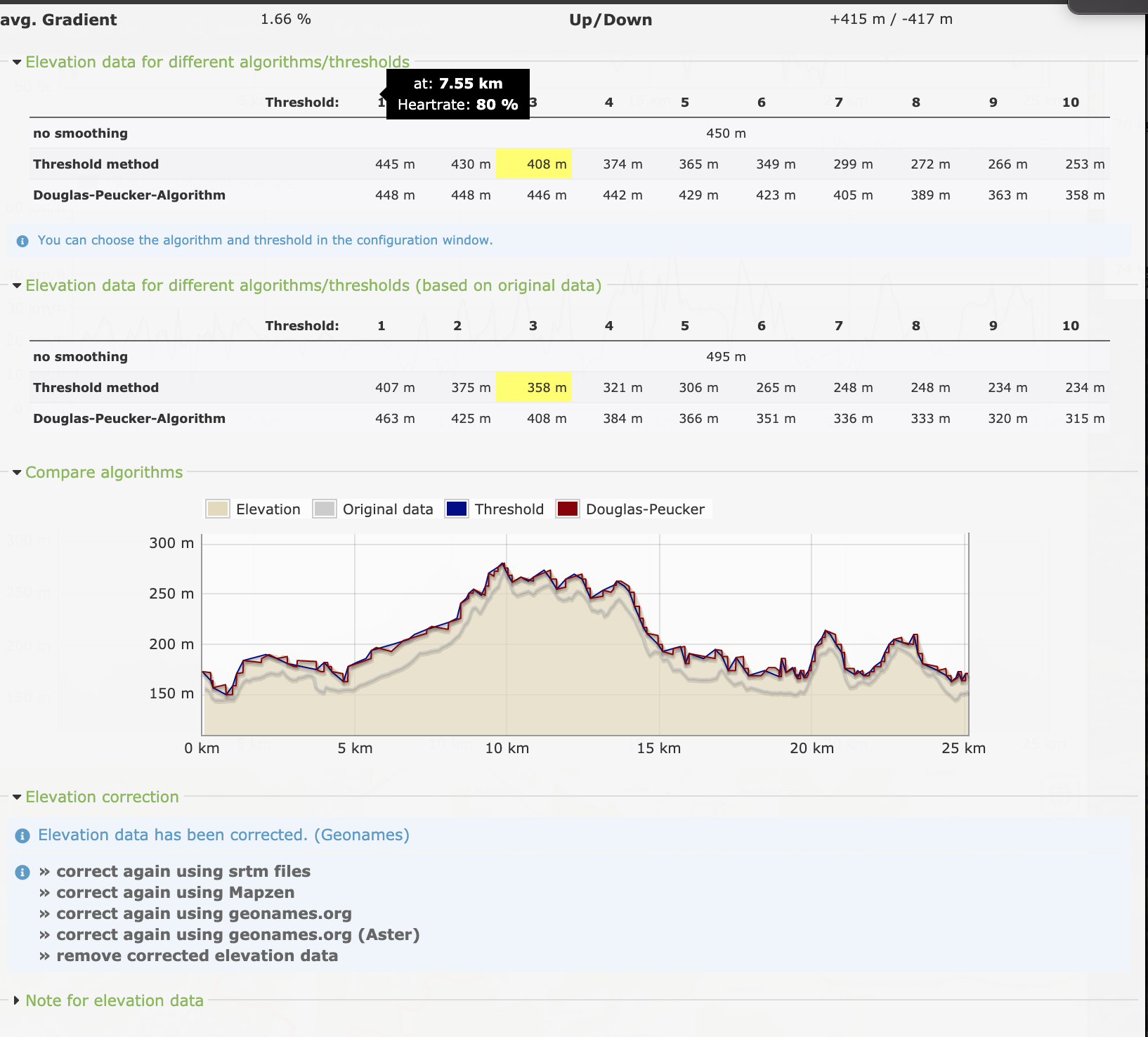
                  Runanalyze!

                  Screenshot 2019-08-19 at 15.13.47.png

                  Community Manager / Admin @Suunto
                  Creator of quantified-self.io - sync Garmin and COROS activities to Suunto, import Suunto routes, deliver Suunto routes to Garmin courses, and analyze training data in one private dashboard.

                  1 Reply Last reply Reply Quote 1
                  • mario_bM Offline
                    mario_b @freeheeler
                    last edited by

                    @TELE-HO perfect. i think you’ve being right, as you said, that i could be, because you calibrated it on the gondola.
                    as you can see, fused-alti is correcting the altitude all the time on the activity to a higher altitude. is the altitude value on the end of the activity nearly correct?

                    freeheelerF 1 Reply Last reply Reply Quote 0
                    • freeheelerF Offline
                      freeheeler @mario_b
                      last edited by

                      @mario_b
                      yes, it is absolutely correct at the end.

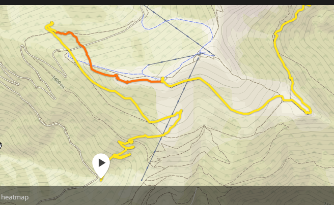
                      I just noticed that I’ve had a GPS precision issue for the first 35minutes of this activity anyway. I wanted to redraw the exact route but saw that the signal was off track at the beginning… it does not make sense to overlay my recorded move with a drawn route I think.
                      c02a811e-6f7e-4a16-9ca7-9966aefad5ea-image.png

                      living sideways

                      mario_bM 1 Reply Last reply Reply Quote 0
                      • mario_bM Offline
                        mario_b @freeheeler
                        last edited by

                        @TELE-HO so i would say, there is nothing wrong with your watch. looking at the ambient pressure at around 930 (which is not anough for the swiss the last weekend) i think it was only a faulty calibration at start. then fused alti kicked in, and corrected the altitude until it was nearly correct. (>1005 hpa at the end sound more possible too). 🙂 👍

                        J 1 Reply Last reply Reply Quote 1
                        • J Offline
                          johann.fuehrer Bronze Member @mario_b
                          last edited by johann.fuehrer

                          @mario_b same opinion. Somewhere at 1 h 15 mins after start it started to look ok.

                          1 Reply Last reply Reply Quote 0
                          • ? Offline
                            A Former User @Dimitrios Kanellopoulos
                            last edited by

                            @Dimitrios-Kanellopoulos Thanks 👍 . Again, sounds logic.
                            After my test that I described below I have this doubt: you know with which frequency the S9B take samples of the barometer to calculate and show the altitude? or which is the frequency that update the altitude displayed?

                            I made a simple test using the S9B, Mobile with barometer and Samsung Gear Frontier. I went downstairs one floor (~4m difference).

                            1st try: S9B not show differences even after ~20sec or a bit more. Mobile and Gear displays the -4m variation instantly, the altitude on these both devices is continuing updating almost on each step that I do down.
                            I went up. Mobile and Gear displays the variation of +4m. S9B again no differences. After around 5 minutes, I see that the S9B display me a -4m difference (wrong), looks like displays me the value from when I was down, but do not register that I went up again.

                            2nd try: Mobile & Gear again displays correct results instantly and continuously. S9B: I decide give more time waiting on each floor. After few seconds or minute waiting on the lower floor, start to display me a variation of -3m, after few minutes I get the -4m. I went up again, +4m after few seconds or almost a minute.

                            Results: Mobile & Gear displayed correct value all the times and instantly. S9B worked tricky. One time showed me a correct result but maintained the difference error created on 1st try. 2nd try was perfect, but need sometime to show me the correct values.

                            J mario_bM 2 Replies Last reply Reply Quote 0
                            • J Offline
                              johann.fuehrer Bronze Member @Guest
                              last edited by

                              @flypg I have read about some threshold value which must be reached until an altitude change is recognized by the watch, I think it was about 3m or somewhere in that range. Maybe this kicks in as well …

                              ? 1 Reply Last reply Reply Quote 0
                              • ? Offline
                                A Former User @johann.fuehrer
                                last edited by

                                @johann-fuehrer Thanks, yes, this is why I would like know with precision to understand a bit more the watch. I think that also exist some timelapse to process this or display this and this results in the “delay” that I see to display the information.

                                1 Reply Last reply Reply Quote 0
                                • mario_bM Offline
                                  mario_b @Guest
                                  last edited by

                                  @flypg if it’s the same algorythm that is used in the ambit3 peak for automatic mode then:
                                  When in watch mode, it messures every 10 sec. if you move up/down more then 5 meters in elevation (around 0,6hpa) in 3 minutes, it switches to alti-mode. when your are moving less then 5 meters in 12 minutes the watch switches back to baro-mode

                                  ? 1 Reply Last reply Reply Quote 1
                                  • ? Offline
                                    A Former User @mario_b
                                    last edited by A Former User

                                    Thanks @mario_b! Now I can understand for what on 1st try the reaction not was immediately and I got better results on 2nd try.

                                    it messures every 10 sec

                                    Wow, I imagined that should be a lower value, by this I expected a faster response in the update of the altitude readings. But really not need a faster update in watch mode, because for this I have the Sport Modes.
                                    Thanks to everyone again!

                                    Dimitrios KanellopoulosD 1 Reply Last reply Reply Quote 1
                                    • Dimitrios KanellopoulosD Offline
                                      Dimitrios Kanellopoulos Community Manager @Guest
                                      last edited by

                                      @flypg it counts higher than 3-5m variations in 12 minutes. If you would go a bit more low then both devices should react the same.

                                      That is to wipe out pressure changes as we talked before

                                      Community Manager / Admin @Suunto
                                      Creator of quantified-self.io - sync Garmin and COROS activities to Suunto, import Suunto routes, deliver Suunto routes to Garmin courses, and analyze training data in one private dashboard.

                                      1 Reply Last reply Reply Quote 0
                                      • Dimitrios KanellopoulosD Offline
                                        Dimitrios Kanellopoulos Community Manager
                                        last edited by

                                        https://www.suunto.com/en-gb/Support/Product-support/suunto_9/suunto_9/valid-for-barometer-version-only/outdoor-insight/

                                        If you are at a constant altitude (less than 5 meters of vertical movement within 12 minutes), your watch interprets air pressure changes as weather changes and adjusts the barometer graph accordingly.

                                        Community Manager / Admin @Suunto
                                        Creator of quantified-self.io - sync Garmin and COROS activities to Suunto, import Suunto routes, deliver Suunto routes to Garmin courses, and analyze training data in one private dashboard.

                                        J 1 Reply Last reply Reply Quote 1
                                        • ? Offline
                                          A Former User
                                          last edited by

                                          Thanks again to everyone!

                                          Yes @Dimitrios-Kanellopoulos, this explains that on all my attempts I generated a altitude variation > 30m in less than 12 minutes (because I went up and down several times more than the 2 tests).
                                          The only that is not totally clear is the variation of 1st try that the S9B not registered this +4 of when I went up.

                                          1 Reply Last reply Reply Quote 0
                                          • J Offline
                                            johann.fuehrer Bronze Member @Dimitrios Kanellopoulos
                                            last edited by

                                            @Dimitrios-Kanellopoulos I have a Spartan Ultra: I’m sitting at the moment in my office at 214m above sea level. I know from the weather station on my altitude just some 2km away, that we have 2015.4 hPa at 30 C temperature. My watch shows me 2021 hPa. If I like to have a correct pressure reading, I would have to change the altitude to 165m. SO how can I bring this together to see correct altitude AND correct pressure?

                                            Dimitrios KanellopoulosD 1 Reply Last reply Reply Quote 0

                                            Hello! It looks like you're interested in this conversation, but you don't have an account yet.

                                            Getting fed up of having to scroll through the same posts each visit? When you register for an account, you'll always come back to exactly where you were before, and choose to be notified of new replies (either via email, or push notification). You'll also be able to save bookmarks and upvote posts to show your appreciation to other community members.

                                            With your input, this post could be even better 💗

                                            Register Login
                                            • First post
                                              Last post

                                            Suunto Terms | Privacy Policy