Suunto app Forum Suunto Community Forum
    • Recent
    • Tags
    • Popular
    • Users
    • Groups
    • Register
    • Login

    Navigation and Climb guidance

    Scheduled Pinned Locked Moved Suunto Race
    27 Posts 10 Posters 1.4k Views
    Loading More Posts
    • Oldest to Newest
    • Newest to Oldest
    • Most Votes
    Reply
    • Reply as topic
    Log in to reply
    This topic has been deleted. Only users with topic management privileges can see it.
    • Dušan KovićD Offline
      Dušan Ković @isazi
      last edited by

      @isazi I will try it out more in the coming days, hope it works better 🙂

      SR
      SA latest beta
      Polar Verity Sense
      Pixel 6

      1 Reply Last reply Reply Quote 1
      • Brad_OlwinB Offline
        Brad_Olwin Moderator @Dušan Ković
        last edited by

        @Dušan-Ković I have tested this by going off route and not completing a route. The guidance has recovered in all cases for me. However, my testing was on foot and not on a bike.

        Vector/T6c/Ambit 3 Peak/S5 Copper/S3/S7 Ti/S9 baro Ti/S9P Ti/S9PP Ti/Vertical Ti/Race Ti/RaceS/Ocean/Wing

        Dušan KovićD 1 Reply Last reply Reply Quote 0
        • Dušan KovićD Offline
          Dušan Ković @Brad_Olwin
          last edited by

          @Brad_Olwin I will try it out on more rides to figure out if it is buggy.

          I was just reading information on the Suunto webpage and saw this:

          aa4bdf8c-5294-438d-9951-023215782475-image.png

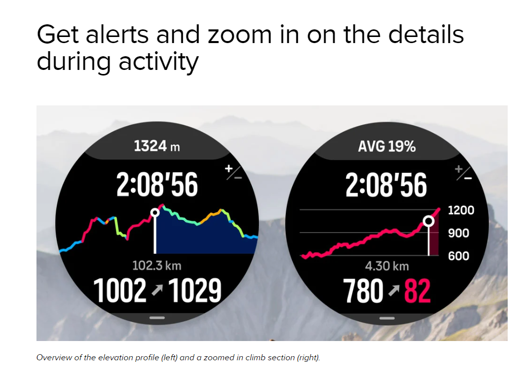
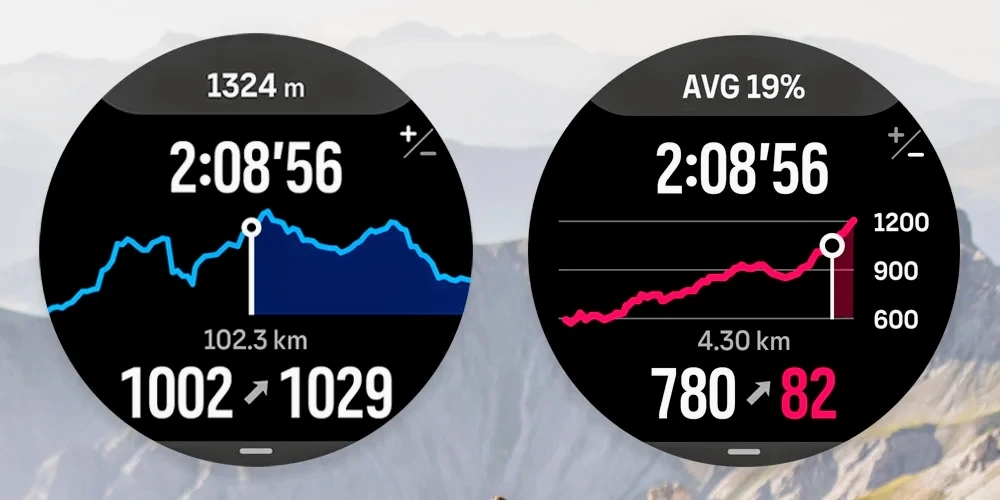
          is the elevation profile supposed to have color coded climbs and downhills? (left picture)
          On my ride today I only had constant blue color, I didn’t have climbs, my route in the app had climbs

          SR
          SA latest beta
          Polar Verity Sense
          Pixel 6

          Brad_OlwinB U 2 Replies Last reply Reply Quote 6
          • Brad_OlwinB Offline
            Brad_Olwin Moderator @Dušan Ković
            last edited by

            @Dušan-Ković Wow! I would love to see that, hopefully it is coming but mine is just blue as well.

            Vector/T6c/Ambit 3 Peak/S5 Copper/S3/S7 Ti/S9 baro Ti/S9P Ti/S9PP Ti/Vertical Ti/Race Ti/RaceS/Ocean/Wing

            Dušan KovićD 1 Reply Last reply Reply Quote 0
            • Dušan KovićD Offline
              Dušan Ković @Brad_Olwin
              last edited by

              @Brad_Olwin

              https://www.suunto.com/en-si/sports/News-Articles-container-page/suuntos-climb-guidance-prepares-you-for-the-terrain-ahead/

              Here is the link

              SR
              SA latest beta
              Polar Verity Sense
              Pixel 6

              1 Reply Last reply Reply Quote 3
              • Ecki D.E Offline
                Ecki D. Bronze Member
                last edited by

                Could anyone tell me where the ascent data comes from? I assume it’s just GPX data that depends on the app used for planning.

                I usually plan my routes with Komoot, and I contacted them a while ago about completely wrong elevation data along the Aegean seashore.

                They told me they bought this data from NASA years ago, and it’s incorrect. They mentioned it’s difficult to resolve.

                Yesterday, I rode in my local area, and the climb guidance showed -1% while I was actually going up about +7%.

                I checked back in Komoot, and the ascent simply isn’t mapped. I couldn’t see it on the bike as it was too short, but I believe there were red lines indicating uphill while the GPX data showed downhill.

                I suspect data from the barometer sensor / GPS is used to verify if I’m still on track.

                Is there any trick to make the Suunto app recalculate the route? It seems the ascent data is much better than Komoot’s. I tried editing an imported route, but the elevation doesn’t change unless you completely replan the route.

                https://www.strava.com/athletes/37982563
                https://www.instagram.com/macdev

                Dušan KovićD 1 Reply Last reply Reply Quote 0
                • Dušan KovićD Offline
                  Dušan Ković @Ecki D.
                  last edited by

                  @Ecki-D Usually companies buy elevation data from different sources. It really depends how old elevation data is and what is resolution of the data set. Suunto had really bad elevation data until recently, it had almost double ascent on some areas. Not sure who provided new data to the suunto, but it is much better than before.

                  I had similar question few days ago - How to update old routes to the new data model without editing them manually. It would be great for suunto to update all our existing and new routs as they are made. Or add button - update elevation or something similar. Maybe this topic would require a new thread, as suunto climb guidance is dependant on the elevation data. It would be great to update everything somehow
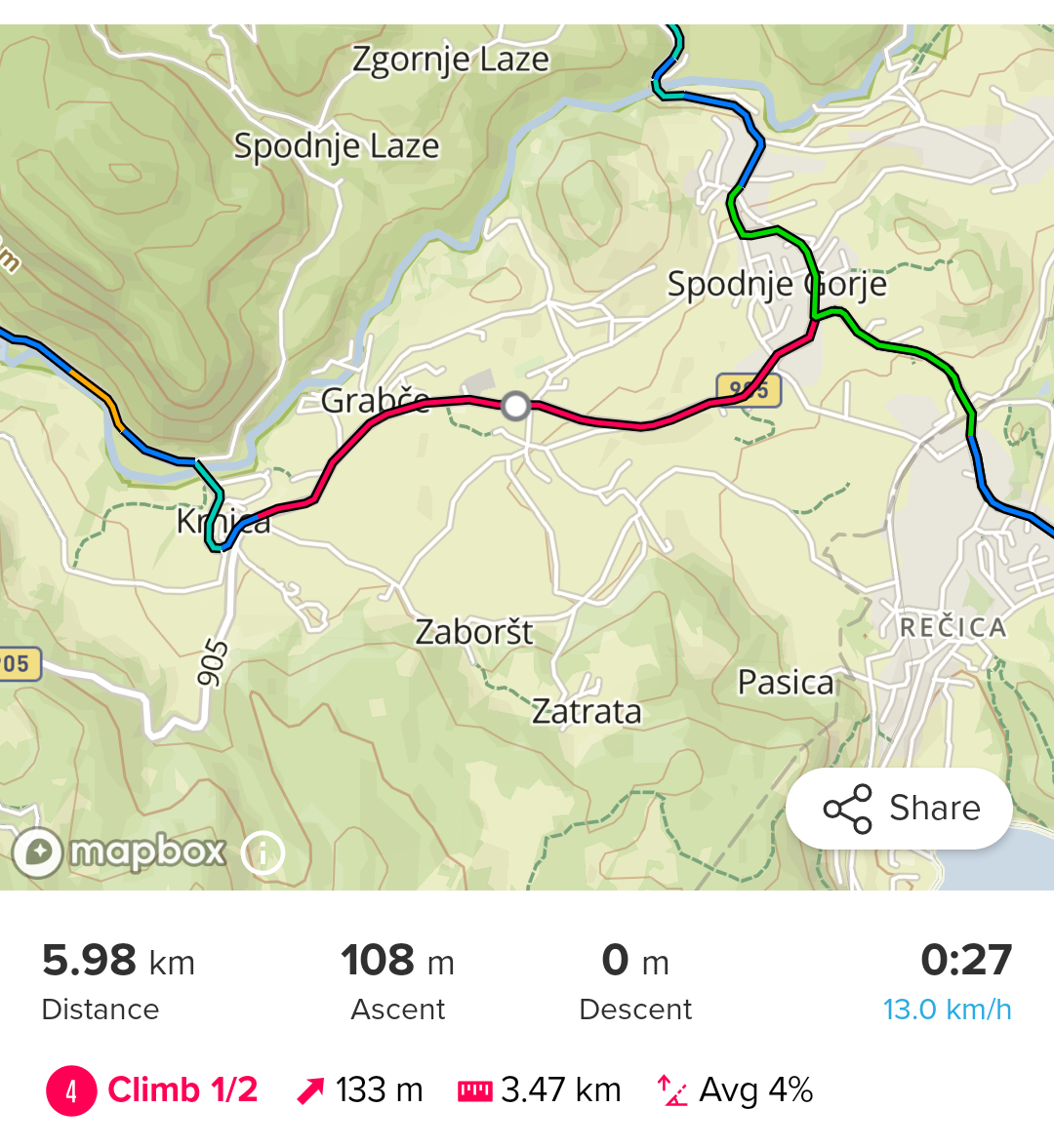
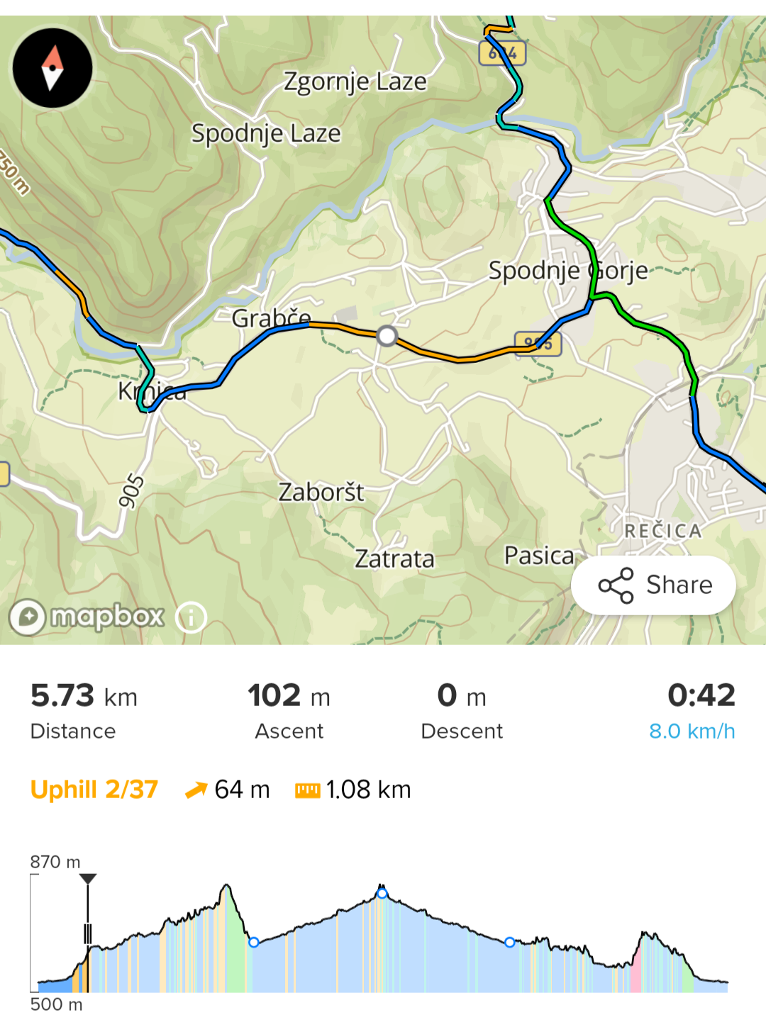
                  SR
                  SA latest beta
                  Polar Verity Sense
                  Pixel 6

                  1 Reply Last reply Reply Quote 4
                  • U Offline
                    uranfl @Dušan Ković
                    last edited by

                    @Dušan-Ković
                    Updated climb picture
                    ui-image-section2~2.jpg

                    Dušan KovićD 1 Reply Last reply Reply Quote 2
                    • Dušan KovićD Offline
                      Dušan Ković @uranfl
                      last edited by

                      @uranfl I hope we get colored ones at one point 😄

                      I had a bike ride today and finally Climb guidance worked. Few observations:

                      • climbs don’t match real world terrain. At multiple occasions I got downhill section before the climb finished. Sections end or start early or late than in reality.

                      • grade percentage on the climbs also doesn’t match real world. At one point I saw 17% grade climb on the sign and watch was showing 12%

                      • I planned same route twice and the app showed different climbs.
                        1000012793.png
                        1000012792.png

                      SR
                      SA latest beta
                      Polar Verity Sense
                      Pixel 6

                      TieutieuT 1 Reply Last reply Reply Quote 0
                      • TieutieuT Offline
                        Tieutieu Platinum Member @Dušan Ković
                        last edited by Tieutieu

                        @Dušan-Ković said in Navigation and Climb guidance:

                        • climbs don’t match real world terrain. At multiple occasions I got downhill section before the climb finished. Sections end or start early or late than in reality.

                        I reviewed that after my first test : it seems to be the « normal » behavior…

                        https://forum.suunto.com/post/147449

                        Suunto’s devices at home :
                        Vertical titanium solar
                        Suunto Race S
                        S9pp titanium sand
                        Suunto Wing
                        S9B titanium Ambassador edition, A3P, X6

                        Dušan KovićD 1 Reply Last reply Reply Quote 0
                        • Dušan KovićD Offline
                          Dušan Ković @Tieutieu
                          last edited by

                          @Tieutieu That also happens, but I got downhill section 2/3 up the real climb. Not few meters before the end

                          SR
                          SA latest beta
                          Polar Verity Sense
                          Pixel 6

                          isaziI 1 Reply Last reply Reply Quote 0
                          • isaziI Offline
                            isazi Moderator @Dušan Ković
                            last edited by

                            @Dušan-Ković as far as I know, this should be fixed with a new firmware release, maybe soon

                            Watch: Suunto Vertical Ti

                            Blog: isazi's home

                            1 Reply Last reply Reply Quote 4
                            • Dušan KovićD Offline
                              Dušan Ković
                              last edited by

                              I just had a bike ride on which I could take a better look on Climb Guidance. It was terrible. it just doesn’t work correctly. On some climbs it breaks single uphill part into part uphill and part flat, but in real world it was all uphill. It just doesn’t translate terrain from real-world to Climb Guidance. I am guessing that big part in this is elevation data available. But still, Suunto should get proper height data. This is just not reliable.

                              SR
                              SA latest beta
                              Polar Verity Sense
                              Pixel 6

                              1 Reply Last reply Reply Quote 0
                              • V Offline
                                vinc14 Bronze Member
                                last edited by

                                Hello
                                this Climb guidance will it also work for Hiking and it is possible to define by my self what is cat 1 to 4?
                                have a nice day
                                vinc

                                • Suunto Vertical Steel solar All Black and Made in Finnland
                                • Suunto Smart Heart Rate Belt
                                • Suunto Zoop

                                Android APP: 4.100.4


                                Linux (Debian) Laptop (No Windows)

                                TieutieuT 1 Reply Last reply Reply Quote 0
                                • TieutieuT Offline
                                  Tieutieu Platinum Member @vinc14
                                  last edited by

                                  @vinc14 as long as you navigate along a route it will work for hiking, cycling, running….
                                  You have no access to any settings except climb guidance alerts on/off

                                  Suunto’s devices at home :
                                  Vertical titanium solar
                                  Suunto Race S
                                  S9pp titanium sand
                                  Suunto Wing
                                  S9B titanium Ambassador edition, A3P, X6

                                  1 Reply Last reply Reply Quote 0
                                  • sorinusS Offline
                                    sorinus
                                    last edited by

                                    Something is not working properly with the way climbs/uphils/descents/downhils sections are calcualted. Last weekend I raced Istria 69K using my Vertical with the last SW. Climb gudiance showed me only 1 climb/uphill section and only 1 short descent/downhill. Completely out of reality and useless. My friend’s Garmin had many more sections and in line with reality.

                                    Is there any setting about climb guidance sensitivity? I couldn’t find any.

                                    If anyone wants to check here is the GPX track I used https://istria.utmb.world/races/69K (my only update to the track was adding 4 waypoints).

                                    Suunto Vertical Ti

                                    Ecki D.E AudaxjoeA 2 Replies Last reply Reply Quote 0
                                    • Ecki D.E Offline
                                      Ecki D. Bronze Member @sorinus
                                      last edited by

                                      @sorinus I do create most of my gpx tracks with komoot and adding those to the suunto app they work for navigation but not so good for climb guidance.
                                      I found when re-editing a gpx track coming from somewhere else climb guidance works much better.
                                      Did you add your waypoints in the suunto app or somewhere else?

                                      https://www.strava.com/athletes/37982563
                                      https://www.instagram.com/macdev

                                      sorinusS 1 Reply Last reply Reply Quote 0
                                      • sorinusS Offline
                                        sorinus @Ecki D.
                                        last edited by

                                        @Ecki-D. I added my waypoints in the suunto app.

                                        Suunto Vertical Ti

                                        1 Reply Last reply Reply Quote 0
                                        • AudaxjoeA Offline
                                          Audaxjoe
                                          last edited by

                                          Sunnto only really counts decent climbs as a climb, the rest it grades as uphill.

                                          I find Suunto much better than Garmin or Wahoo, but it is down to personal preference.

                                          If Suunto tell me a climb is coming I know it is a climb!

                                          Wahoo gives nearly any slope climb status and Garmin seems to be in the middle.

                                          Sometimes the Wahoo also breaks one coin into several sections. I do not find the Suunto doing this but it does often not count climbs that are short.

                                          I rode across Spain a couple of weeks ago, Atlantic to the Mediterranean, Id always check the Suunto climbs to get a good idea of the terrain for the day. I thought it was excellent.

                                          But it certainly only marks climbs that you will most definitely notice! I use the Vertical.

                                          Suunto Vertical
                                          Suunto 9 BARO
                                          Garmin Fenix 3, 5
                                          Suunto Vector

                                          1 Reply Last reply Reply Quote 1
                                          • AudaxjoeA Offline
                                            Audaxjoe @sorinus
                                            last edited by

                                            @sorinus “in line with reality” I guess that depends on your reality.

                                            One person’s mountain is another person’s hill!

                                            For me I like the conservative nature of the Suunto climbs guidance.

                                            I have a wahoo also. That is just daft. I have it set to med/hard climbs only and most are just slops

                                            People with Garmin seem in the middle.

                                            On some routes last year when riding with friends at the start of the day the Suunto would show one climb, Garmin maybe 15 and the Wahoo about 30 🤣

                                            I wouldn’t say any are wrong, just a different approach.

                                            Suunto Vertical
                                            Suunto 9 BARO
                                            Garmin Fenix 3, 5
                                            Suunto Vector

                                            sorinusS 1 Reply Last reply Reply Quote 0
                                            • First post
                                              Last post

                                            Suunto Terms | Privacy Policy