Suunto app Forum Suunto Community Forum
    • Recent
    • Tags
    • Popular
    • Users
    • Groups
    • Register
    • Login

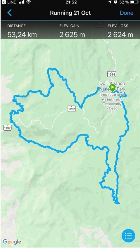
    differ eleve gain in suunto app

    Scheduled Pinned Locked Moved Suunto app - Questions & Feedback
    15 Posts 6 Posters 482 Views
    Loading More Posts
    • Oldest to Newest
    • Newest to Oldest
    • Most Votes
    Reply
    • Reply as topic
    Log in to reply
    This topic has been deleted. Only users with topic management privileges can see it.
    • S.PichiS Offline
      S.Pichi
      last edited by S.Pichi

      dear All,

      i just got the route in gpx format , but when i imported them to SA .
      i got the eleve.gain differ from garmin . well understnad that could not be the same due to algorithm. But i think this time is differ around 1000m !
      i am not sure which one is correct
      garmin.jpg

      Thanks,suunto.jpg

      BulkanB 1 Reply Last reply Reply Quote 0
      • BulkanB Offline
        Bulkan Moderator @S.Pichi
        last edited by Bulkan

        @s-pichi it depends of the devices you are comparing.

        Are both with barometer? My guess is that one is with a non barometer device. In a rolling course if the changes aren’t superior to ±7m the suunto watch won’t register that elevation.

        We need more info: devices you are comparing, climate conditions, wrist right or left the suunto? if correction of elevation is on in Garmin web…

        If you have a barometer devices check the sensor is clean.

        Tu comunidad Suunto en Telegram: https://t.me/suuntocommunity (spanish)

        S.PichiS 1 Reply Last reply Reply Quote 0
        • S.PichiS Offline
          S.Pichi @Bulkan
          last edited by

          @bulkan for this case , i do not yet imported this route to device .
          Just in first step that importing to route in suunto app and getting the gain like above .

          isaziI 1 Reply Last reply Reply Quote 0
          • isaziI Offline
            isazi Moderator @S.Pichi
            last edited by

            @s-pichi just to be clear, this is from a GPX file created in GC and imported into SA, or a GPX file imported in both GC and SA? And can you provide the GPX file to check?

            Watch: Suunto Vertical Ti

            Blog: isazi's home

            S.PichiS 1 Reply Last reply Reply Quote 0
            • S.PichiS Offline
              S.Pichi @isazi
              last edited by S.Pichi

              @isazi this is a GPX file imported in both GC and SA.
              the gpx file is as below

              https://drive.google.com/file/d/1iIuJ0y9EG5TbmDngnMP96WsjhvO5tmB6/view?usp=sharing

              isaziI 1 Reply Last reply Reply Quote 1
              • isaziI Offline
                isazi Moderator @S.Pichi
                last edited by

                @s-pichi thanks, I will look at it.

                Watch: Suunto Vertical Ti

                Blog: isazi's home

                1 Reply Last reply Reply Quote 0
                • Stas VarazhbitS Offline
                  Stas Varazhbit
                  last edited by

                  I also noticed the difference in height in SA and GC, when loading the same GPX file.SA and GC.JPG

                  Suunto 9P
                  Suunto 9 no baro
                  Suunto Ambit3S

                  1 Reply Last reply Reply Quote 0
                  • isaziI Offline
                    isazi Moderator
                    last edited by isazi

                    I will try few different tools and if the majority is different from SA will fill in a bug with Suunto.

                    Watch: Suunto Vertical Ti

                    Blog: isazi's home

                    1 Reply Last reply Reply Quote 0
                    • TheGuyFromTheSummitT Offline
                      TheGuyFromTheSummit Silver Members
                      last edited by

                      This is the same with other route planning apps as well

                      Even when you track an activity with a Suunto watch and then import the track into GC and SA.
                      GC has 10-20% more ascent.

                      I do not know why and no idea which app is right.

                      1 Reply Last reply Reply Quote 0
                      • Stas VarazhbitS Offline
                        Stas Varazhbit
                        last edited by

                        In my case, the SA indications agree with the data of the race organizers, and the GC indications are underestimated.

                        Suunto 9P
                        Suunto 9 no baro
                        Suunto Ambit3S

                        1 Reply Last reply Reply Quote 1
                        • isaziI Offline
                          isazi Moderator
                          last edited by

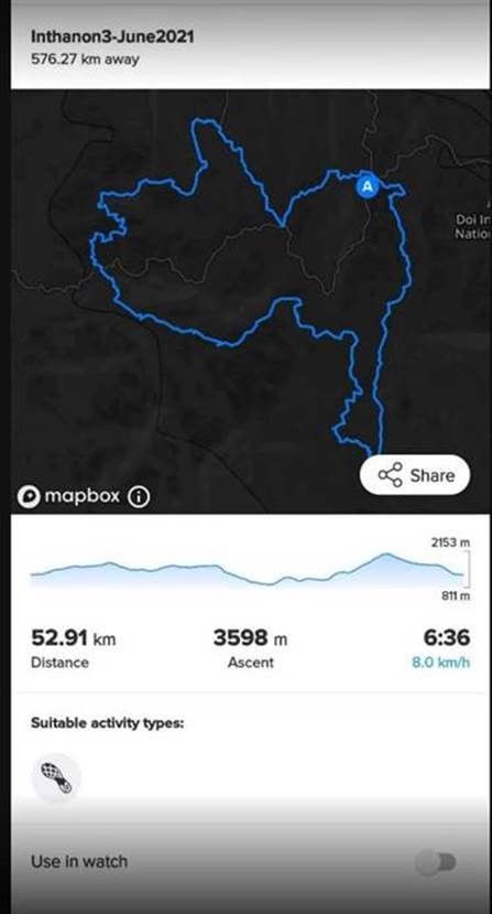
                          So far I tried Komoot and Plotaroute. Komoot finds two different tracks in the file, one having ascent equal to 2540 and the other to 1760. Plotaroute finds only one route with ascent of 2880.

                          Watch: Suunto Vertical Ti

                          Blog: isazi's home

                          TheGuyFromTheSummitT 1 Reply Last reply Reply Quote 0
                          • TheGuyFromTheSummitT Offline
                            TheGuyFromTheSummit Silver Members @isazi
                            last edited by

                            @isazi

                            alpenvereinaktiv.com says the following:

                            a051a105-1ef7-44da-b58f-cfa74036e5f6-grafik.png

                            pilleusP 1 Reply Last reply Reply Quote 0
                            • pilleusP Offline
                              pilleus @TheGuyFromTheSummit
                              last edited by

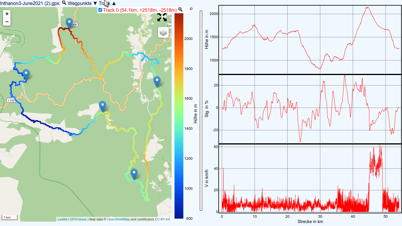
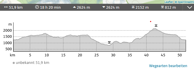
                              With https://www.j-berkemeier.de/ShowGPX.html there are the attached results …

                              Bildschirmfoto zu 2021-10-29 14-45-49.png

                              https://www.instagram.com/moves.are.life/
                              Suunto Vertical Black Lime
                              Suunto 9 Peak Pro Black
                              Suunto Spartan Ultra Stealth Titanium

                              1 Reply Last reply Reply Quote 0
                              • isaziI Offline
                                isazi Moderator
                                last edited by

                                And using gpx.studio gives an ascent of 3198.

                                Watch: Suunto Vertical Ti

                                Blog: isazi's home

                                1 Reply Last reply Reply Quote 0
                                • isaziI Offline
                                  isazi Moderator
                                  last edited by isazi

                                  Another update on this, I just wrote a simple script in Python to manually compute ascent and descent of all tracks and routes contained in a GPX file, and the result for this file is 3598 meters of ascent and descent.

                                  This is the same number that we can see in SA. So simply SA does not apply any filter to the data, and counts every meter of ascent of the GPX file.

                                  Conclusion: I will not open a bug with Suunto. Maybe not very sophisticated, but the SA implementation is coherent with the data.

                                  Watch: Suunto Vertical Ti

                                  Blog: isazi's home

                                  1 Reply Last reply Reply Quote 4
                                  • First post
                                    Last post

                                  Suunto Terms | Privacy Policy