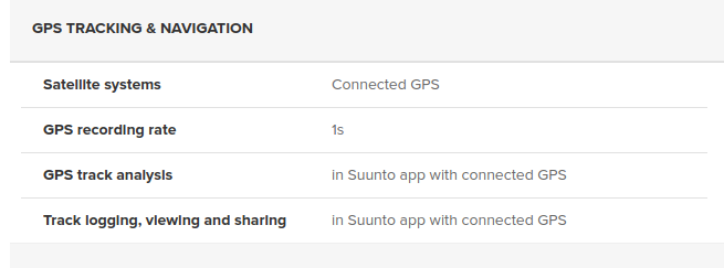
Connected GPS feature SF3/Galileo supported smartphones
-
So by now we know that S3F will have connected GPS from smartphone.
Would be very important if USERS of this Forum/App can make some tests to see accuracy with ‘Record with app’ feature in smartphones that support Galileo GNSS like Huawei P9, P10, BQ Aquaris V,X,X5, Google Pixel 2, LG V30, Samsung S8, S9, Galaxi S3, Note 8, Sony Xperia XZ,XZ1,XZ2 and OnePlus 5/T (android) or iPhones, models 6, 7, 8 and X (iOS). Someones can also receive BeiDou signals.
The premise is that application will register the route with the 3 systems together (Navstar + Glonass + Galileo) or even (Nv + GL + Ga + Bd).
Who wants volunteer to publish here?
-
I will ride later this day, I can publish here, what exactly do you need?
How can we compare them, I track first with the Record in App function, post all the data here and then erase it and take the route from the watch? I guess there is no way to export the GPX, or wait, take it from SportsTracker?
-
@jthomi Thanks! If possible printscreens of route in different scenarios - city vs rural. I think is possible to export files from SportsTracker by select an activity - Edit - export - gpx files.
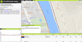
The best it is record from app (smartphone) and with Suunto watch. Then export 2 files and open in this web app: http://www.mygpsfiles.com/app/ (you can open .gpx or .tcx) with selected activities at same time to compare.SR
Site (gr7vel spin): https://youtube.com/channel/UCfHM0mXWS8S61h70Rzj9mfA -
Today is more of a bike path ride along the river, mostly plain sight to the sky. Tomorrow will be different, more time in the woods.
-
And the site you mentioned enables sharing of the imported tracks so here! Even better!
-
@jthomi Seems app do not track elevation?
-
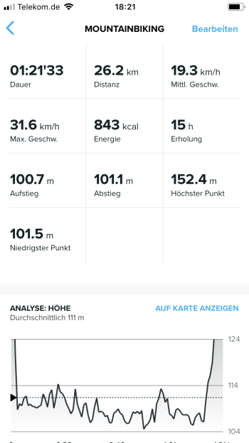
@slashas App tracked elevation as well.
Here is a screenshot from the iPhone data.
-
@slashas It was mostly flat ride along the river with just a little elevation. Tomorrow will be a different ride, with more ups and down, will post it here again.
-
@jthomi so why mygpsfile missing it?
-
@jthomi At first view seems that are very close, but i guess watch is better. More stable line and close to tracks, no?
Which model of smartphone did you use and in watch did you use Navstar+Glonass or without Gl? -
@slashas Elevation is on corner at left in app.
SR
Site (gr7vel spin): https://youtube.com/channel/UCfHM0mXWS8S61h70Rzj9mfA -
@slashas
-
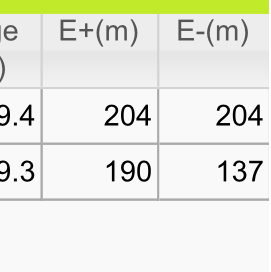
@luís-pinto but why one the right it is stuck on 204?
-
@slashas Or there is a bug on graph or in values of table. The zone in question (maybe a valley) i bet that graph have right values.
-
@slashas We need also the specifications of watch and smartphone if have barometer or not…
-
Its the Suunto Spartan Sport in shiny Blue, so without Baro.
And the iPhone7 with newest iOS.
But now that you mentioned it, the tracking of elevation in the app was with GPS not Barometer. And it may sound dumb, but my iPhone7 has a barometer? Oh, my, just seeing it right now, who knew…
I can switch the barometer on tomorrow for the other ride. -
Maybe the app was exactly 204 descent and ascent? The screenshot from the data in the app is also pretty close, only 0,40 meters off.
@slashas said in Connected GPS feature SF3/Galileo supported smartphones:
@luís-pinto but why one the right it is stuck on 204?
-
@slashas said in Connected GPS feature SF3/Galileo supported smartphones:
@jthomi so why mygpsfile missing it?
This is ascent total ascent
-
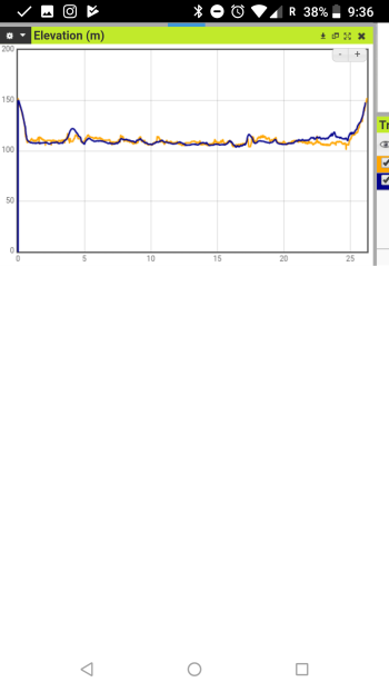
This is the elevation profile comparison
-
Mygps files calculates its own way the ascent.
All day in comparison look fine do not create a problem out of this.