Totalt ascent/descent doesn't seem to match elevation graph
-
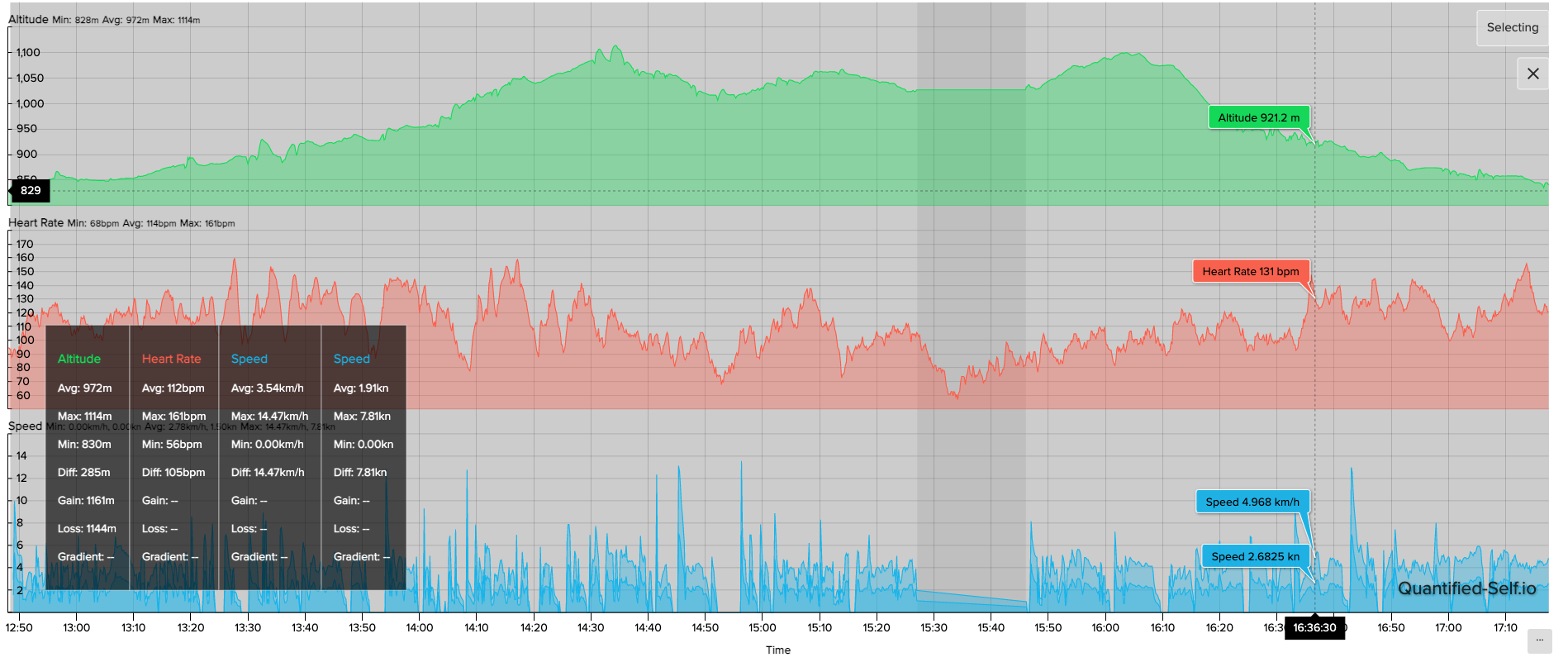
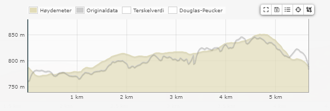
I went snow shoeing on Saturday and after finishing the walk I noticed that ascent and descent seemed way off. I figured maybe my clothes had been messing with the sensor as I was wearing it under a jacket. Figured air might have been pumped into the sensor while walking. When looking at the activity though, the actual elevation graph seems pretty good. So much so I’m wondering how on earth the watch concluded that the ascent is 903 m and descent is 906. My maths may be terrible, but to me that doesn’t make sense given the elevation graph I have. My wife got almost exactly half of this (fenix 5) on ascent and descent. When looking at the elevation graph I’d say that sounds roughly like what I would expect as well.

The activity can be viewed here:
https://quantified-self.io/user/DUrrVK0qMVZO5TtAP0r6Ox2HVLD2/event/3498d61c4133a7e0ba44977d488846683627311e0cf8d0b787eabe44d9381a5c -
-
@dimitrios-kanellopoulos maybe I’ve misunderstood something, but from that picture I’m still failing to see how my total ascent/descent is over 900 meters. Is there something specific I should be looking at?
-
@aleksander-h there are some little bumps of up and down if you notice. almost where I have the cursor in my pic.
I am not sure if those are real tbh
-
@dimitrios-kanellopoulos I’d say those small bumps probably aren’t correct, especially at that point in the trip as it was mostly down hill

-
Easy test, if you have Runalyze and you upload the FIT file it will not use the ascent/descent from the FIT file but recompute them from altitude data. It is a good way to check if there is something wrong with your measured altitude or with the ascent/descent computation. Plus you can play with different engines to correct elevation, and compare with your measured one.
-
@isazi said in Totalt ascent/descent doesn't seem to match elevation graph:
Easy test, if you have Runalyze and you upload the FIT file it will not use the ascent/descent from the FIT file but recompute them from altitude data. It is a good way to check if there is something wrong with your measured altitude or with the ascent/descent computation. Plus you can play with different engines to correct elevation, and compare with your measured one.
Thanks, that would definitely make it easier to investigate this. I did try manually calculating how much the small bumps add up to, but quickly realised it wasn’t going to work
 .
. -
@isazi without using elevation correction, I’m getting a little more than what the suunto app does.
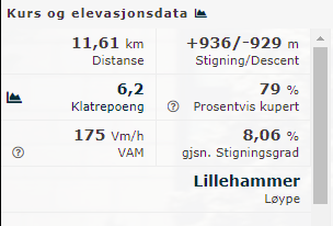
I guess those bumps in the elevation graph really add up. Corrected using RacemapElevationService I get a smoother graph and an ascend/descend which sounds much more realistisc (305).
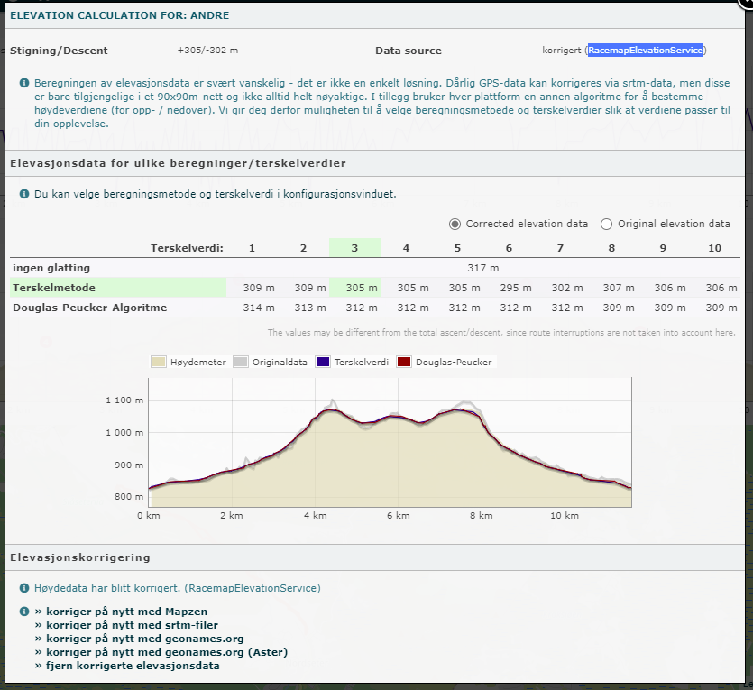
Wonder how I can avoid those elevation bumps in the future
-
@aleksander-h is this the first time or you usually get higher ascent/descent values?
-
@isazi I’m not really sure. I’ve never really payed much attention to it before now. I only noticed now because 900m sounded ridiculous. I’ll have to look through my other activites.
-
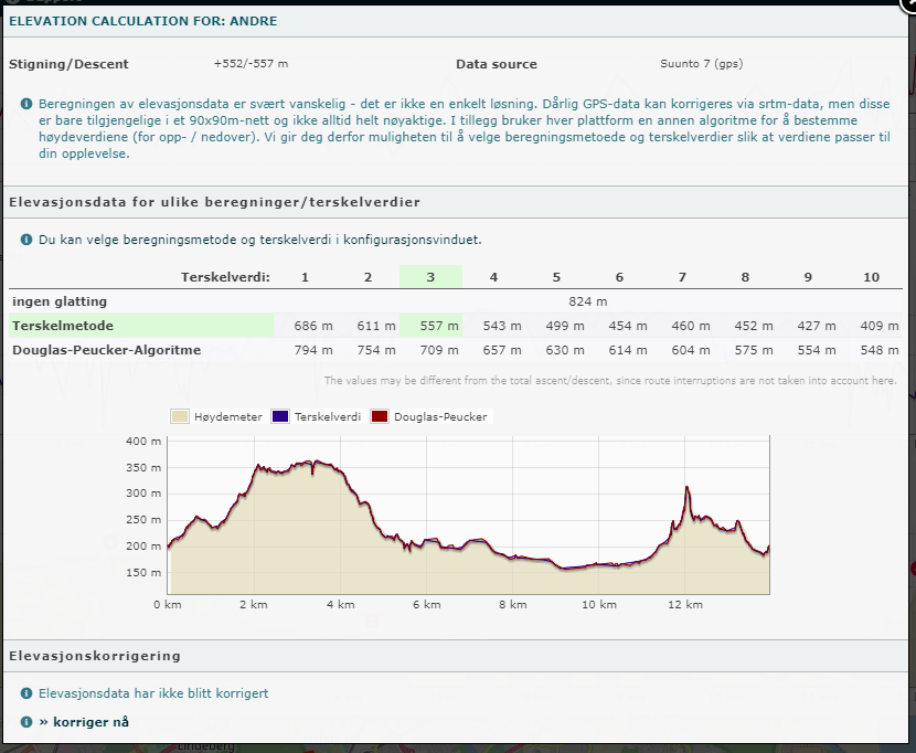
@isazi Here’s an interesting one. It claims ascent was 0m, despite the elevation graph clearly showing ascents taking place during said activity.
Runalyzer manages to calculate an ascent here (Stigning)
-
@aleksander-h strange, the ascent of my S7 usually matches my S9 when I wear them together.
-
@isazi looking at other activities it seems my S7 does a lot of up and downs during activities. Here’s another example. Hard to know what the most accurate is. That said, my wifes Fenix 5 seems much closer to the values suggested by Runalyze correction.
-
@aleksander-h my suggestion would be to pay attention to this to understand how often it happens, how serious it is. And try all the general tips, like cleaning the watch, try to wear it on the other wrist, etc.
-
Could it be related to any data its pulling in based on the GPS fix?
Reason I ask, is because this mornings tracking is the first time I had an issue - started me 100m lower than my actual altitude. Normally around 69m and started me at -32m.Now its possible my jacket may have blocked the hole etc - but I though that the start position was based off GPS fix which was solid before I started; and in the +50 tracking I have started from that position it has never started me at a negative altitude.
Rest of the altitude profile tracked fine, with usual ascent and descent based on that route, which suggests the hole wasn’t blocked or at issue.
-
@jamie-bg found another weird one today, while looking back at previous activities.

Ascent is 0m. Yet I have an ascent time of over 1 hour, and the elevation graph clearly shows an ascent taking place. Also claims lowest point is 321 which is way off. Should be somewhere between 185 and 200 m (can’t remember exactly the elevation where I live).
-
@aleksander-h maybe you should send the link to this (or other) activities to @Dimitrios-Kanellopoulos to check if something is wrong in the app or the watch.
-
@aleksander-h
are these activities really synced with SA and watch ? and not sent to cloud through any rungap/syncmyctracks or whatever ? When i see ascent or descent =0 i am wondering. -
@mff73 said in Totalt ascent/descent doesn't seem to match elevation graph:
@aleksander-h
are these activities really synced with SA and watch ? and not sent to cloud through any rungap/syncmyctracks or whatever ? When i see ascent or descent =0 i am wondering.Yup. Synced directly from S7 to Suunto app. 0m seems to be from the activity file, as that is what I get on Strava and quantified-self as well. This only seems to happen with “Hike” activity, although that might be a coincidence.
-
So did another activity yesterday afternoon - same thing - started my at -32m (actual altitude is between 50-100 based on contour lines, and per previous readings from watch is always around 69-72m).
So I stopped and restarted - thought maybe as started inside fix wasn’t good. Same issue. So put watch into plane mode waited a minute - no joy - still reading same. So took watch out of plane mode and got on with activity. 3 minutes into activity I checked altitude and was back at normal i.e. 76m (probably right for the position in my route).Looking at track in Suunto phone app - all looked good for start, ascent, descent and end.So just been out this morning - and exact same issue (though started at -12m) - did same as yesterday (plane, out of plane mode) and it corrected itself - tracking ascent & descent fine.
Will later this afternoon tomorrow the following two things:
- Start and keep in plane mode - how does that affect readings.
- Start as per normal - if incorrect altitude at start leave it alone and see if it corrects, without having to go plane mode on and off.
To me it definitely looks like its pulling incorrect data with initial fix - never done this before, and if like previously suggest GPS updates done on a monday, got to wonder if there isn’t a FUBAR that is causing this (hope this is it and a recent update isn’t causing this issue - can’t tell as only recently started to tracking again since update, so have immeadiate update tracked records to refer to).
